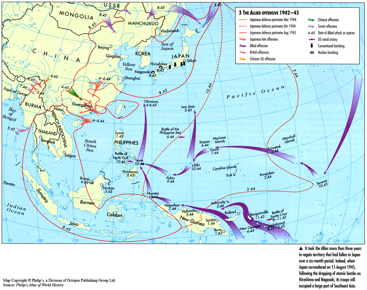
Category Archives: Unrestricted

The Church during the Great Schism 1378-1417

Caption

The Church during the Great Schism 1378-1417

Summary

This map shows a divided Church after a disputed papal election in 1378.
For about forty years, Europe had separate popes.

Source

‘Oxford Atlas of World History, Oxford University Press, 1999. General Editor Patrick K. O’Brien. (p. 107)

Copyright

Map copyright © Philip’s, a division of Octopus Publishing Group Ltd.
Source: Philip’s Atlas of World History

Used under license from Octopus Publishing Group.

Series

This map is one in a series of maps selected from the Oxford Atlas of World History.

A gallery using flyover images like this

Openness to Trade 1980
can be viewed here.

The Chinese Republic with Tibet and Mongolia c. 1935

Caption

The Chinese Republic with Tibet and Mongolia – Political, Racial, and Linguistic

Inset: The modern Subdivisions of the Mongol Republic

Summary

This color-coded map indicates the various “Races and Languages” coexisting in Asia circa 1935. It also shows the political boundaries of the Chinese Republic and the 28 Provinces.

Legend for “Races and Languages”:

  • Indo-Chinese
    • Chinese (Wu, Fukien, Hac-ka (Hakka), Canton dialects)
    • Thai, Yao, Hsia-min
    • Tibetan-Burmese
    • Lo-lo, Mo-so, Li-su, Kachin
    • Miaso, Man
  • Indo-Aryans
    • Russians, Iranians, Tadjik
    • Indians
    • Dardi, Chitralia, Kafir
    • Aryans spelling Turkish
  • Ural-Altaians
    • Turks
    • Tuwinsk
    • Tungan, Taranchi
    • West and East Mongols
    • Tungus
  • Austronesians
    • Mon, Khmer, Munda
    • Primitive Malays
    • Proto-Malays
    • Propre Malays
    • Japanese, Coreans (sic) and Ryukyu Islanders
    • Ainu, Ghiliak
    • Dravidians
    • Negrito

Source

History and Commercial Atlas of China, Albert Herrmann, Ph.D., Harvard University Press, 1935.

See Huhai Website.

Copyright status

Public license
This work is believed to be in the public domain because its copyright is believed to have expired.

Series

This map is one in the series:

The Chinese world, 7th-8th centuries

Caption

The Chinese world, 7th-8th centuries

Summary

This map depicts the history of the Tang (T’ang) Empire (618 – 907) and its neighbors
as far west as the Caspian Sea. The zone of Chinese cultural dominance during this time is also delineated.

The expansion of Tibet and the advance of Islam are shown, together with trade routes and canals.

Captions give brief descriptions of the Nan-Chao Kingdom, the Khmer Kingdom,
the Pohai (Parhae) Kingdom, and various ethnic groups, including the Emishi (Japan),
the Khitan (Liao), Turks, and Uighurs.

Copyright status

Copyright © Times Books 2007
Reproduced from The Times Complete History of the World by permission of HarperCollins Publishers Ltd.

Licensing

All rights reserved

Source

The Times Complete History of the World (2007), p. 139

The Caliphate and After – Important Routes from 10th to 15th Century

Caption

The Caliphate and After – Important Routes from 10th to 15th Century

Summary

The map shows the major overland transportation routes from the 10th to the 15th centuries within the area of the Caliphate, including modern-day Iraq, Iran, Afghanistan, Turkmenistan, and Pakistan. The Khurasan Route extends eastwards from Baghdad to the Oxus River, Bukhara, Samarkand, and Uzkand.

Source

Medieval Routes to India: Baghdad to Delhi – A Study of Trade and Military Routes

Produced by H.C. Verma (Department of History – University of Delhi), Published by Mustafa Waheed, Printed at Islamia al Saudia Printers, Lahore, 1983.

Copyright

None Asserted.

The Chinese in southeast Asia c. 1980

Caption

The Chinese in southeast Asia

Summary

The map purports to identify the main areas of concentration of Chinese people in
southeast Asia, as well as other areas of Chinese settlement, apparently in about 1980.

The map does not distinguish between immigrants who originally came
from China, Han immigrants from China, the descendants of such people,
and people who speak a Chinese language as their mother tongue.

The criteria for determining the shading are also unstated.

According to the source, by the 1980s, there were 6 million “overseas
Chinese” in Thailand, 4 million in Malaysia, and more than 3 million
in Indonesia. The term overseas Chinese however is
similarly ambiguous.

Copyright status

Copyright © Times Books 2007
Reproduced from The Times Complete History of the World by permission of HarperCollins Publishers Ltd.

Licensing

All rights reserved

Source

The Times Complete History of the World (2007), p. 311.

The Break-up of the Soviet Union since 1991

Caption

The Break-up of the Soviet Union since 1991

Summary

This map shows the immigration and refugee movement after the break up of the USSR, post 1991.

Source

Oxford Atlas of World History, Oxford University Press, 1999. General Editor Patrick K. O’Brien. (p. 262)

Copyright

Map copyright © Philip’s, a division of Octopus Publishing Group Ltd.
Source: Philip’s Atlas of World History

Used under license from Octopus Publishing Group.

Series

This map is one in a series of maps selected from the Oxford Atlas of World History.

A gallery using flyover images like this

Openness to Trade 1980
can be viewed here.

The Atlantic Economies 1650-1750

Caption

The Atlantic Economies 1650-1750

Summary

This map shows the key resources in Western Europe, like woolens and linen from 1650 to 1750..

Source

‘Oxford Atlas of World History, Oxford University Press, 1999. General Editor Patrick K. O’Brien. (p. 129)

Copyright

Map copyright © Philip’s, a division of Octopus Publishing Group Ltd.
Source: Philip’s Atlas of World History

Used under license from Octopus Publishing Group.

Series

This map is one in a series of maps selected from the Oxford Atlas of World History.

A gallery using flyover images like this

Openness to Trade 1980
can be viewed here.

The Avars in the 6th Century

Caption

The Avars in the 6th Century

Summary

This map shows the Avars’s migration routes, along with Byzantine Empire boundaries from 550-600 in eastern Europe.

Source

Oxford Atlas of World History, Oxford University Press, 1999. General Editor Patrick K. O’Brien. (p. 76)

Copyright

Map copyright © Philip’s, a division of Octopus Publishing Group Ltd.
Source: Philip’s Atlas of World History

Used under license from Octopus Publishing Group.

Series

This map is one in a series of maps selected from the Oxford Atlas of World History.

A gallery using flyover images like this

Openness to Trade 1980
can be viewed here.

The Art and Architecture of the holy Land and its Influence on the West

Caption

The Art and Architecture of the Holy Land and its Influence on the West

Summary

This map shows the diffusion of stylistic influences from the Holy Land into Western Europe. In particular the Holy Land’s architecture and painting transferred into styles found in the West.

Source

Atlas of Western Art History. Facts on File, Inc., New York, 1994, page 97

Antony White Publishing Ltd.

Copyright

© Parchment Books Ltd. This appears to be an “orphan work”. If you can help us locate the copyright holder, please send mail to qed@princeton.edu.

The Art of the Pilgrimage Routes

Caption

The Art of the Pilgrimage Routes

Summary

This map, focusing on France and northern Spain, shows art produced along major pilgrimage routes. Pilgrimage routes were major agents in circulating different styles and mediums from one town and region to the next.

Source

Atlas of Western Art History. Facts on File, Inc., New York, 1994, page 101

Antony White Publishing Ltd.

Copyright

© Parchment Books Ltd. This appears to be an “orphan work”. If you can help us locate the copyright holder, please send mail to qed@princeton.edu.

The A-B-C Airways Guide Map of Europe, 1953

Caption

The A-B-C Airways Guide Map of Europe

Summary

Map shows air routes providing table numbers which represent the operators of routes. Regular and irregular scheduled services are distinguished. Inset maps show U.K. and Eire, and Iceland.

Index Publishers (Dunstable) Ltd., Dunstable, Bedfordshire.

Source

This map is Map Number 5952 in the collection of copyrighted maps of the Geosciences and Map Library, Fine Hall (B level), Princeton University..

Copyright

Thomas Skinner & Co. (publishers) Ltd. Proprietors.

The date shown on the map, November 1953, seems to be the publication date.

This work may still be under copyright and therefore care is required in its use. Its use on QED is under the “Fair Use” rule.

The Allied Offensive 1942-45

Caption

The Allied Offensive 1942-45

Summary

The map shows the military actions taken by the Allies and the Axis during the Second World War from 1942 to 1945 in east Asia and the Pacific.
There are also references to sites of bombings, most specifically in Japan.

Source

Oxford Atlas of World History, Oxford University Press, 1999. General Editor Patrick K. O’Brien. (p. 235)

Copyright

Map copyright © Philip’s, a division of Octopus Publishing Group Ltd.
Source: Philip’s Atlas of World History

Used under license from Octopus Publishing Group.

Series

This map is one in a series of maps selected from the Oxford Atlas of World History.

A gallery using flyover images like this

Openness to Trade 1980
can be viewed here.

Teubners Weltwirtschaftskarten III 2


Image:Teubners Weltwirtschaftskarten III 2.jpg – QED


Image:Teubners Weltwirtschaftskarten III 2.jpg

From QED

Jump to: navigation, search

Contents

Summary

Teubners Weltwirtschaftskarten
Herausgegeben von Professor K. von der Aa und Dr. E. Fabian
III. 2. Mais, Hafer, Gerste
Hafer-Ernte 1925, Mais-Ernte 1925, Gersten-Ernte 1925
Verlag von B.G. Teubner, Leipzig.

Export and Imports of Corn (Maize), Oats and Barley in 1925.

Markings

  • Sticker: A.J. Nystrom & Co. Educational Map Publishers. Chicago Illinois.
  • Stamped: Printed in Germany

Copyright status

This work may still be under copyright and therefore care is required in its use. Its use on QED is under the “Fair Use” rule.

An attempt to clarify the copyright status was made on May 10, 2006 via email to weiss@stiftung-teubner-leipzig.de as per http://www.stiftung-teubner-leipzig.de/

Source

A.J. Nystrom & Co., Educational Map Publishers, Chicago, Illinois.

The print from which the digital image was made is in the GIS Library, Princeton University.

This map is Map Number 6051 in the collection of copyrighted maps of the Geosciences and Map Library, Fine Hall (B level), Princeton University.

Teubners Weltwirtschaftskarten III 3

Caption

Teubners Weltwirtschaftskarten, III.3. Kaffee, Tee, Kakao

Summary

Teubners Weltwirtschaftskarten
Herausgegeben von Professor K. von der Aa und Dr. E. Fabian
III. 3. Kaffee, Tee, Kakao
Kakao-Ernte 1925, Kaffee-Ernte 1925/26, Tee-Ernte 1925
Verlag von B.G. Teubner, Leipzig.

Coffee, Tea, Cocoa.

Insets:

  • Harvest statistics
  • Consumption of Coffee, Cocoa and Tea in 1925 (bar chart)
  • Production by country
  • Production by continent

Markings

  • Sticker: A.J. Nystrom & Co. Educational Map Publishers. Chicago Illinois.

Printed in Germany

Copyright

This work may still be under copyright and therefore care is required in its use. Its use on QED is under the “Fair Use” rule.

An attempt to clarify the copyright status was made on May 10, 2006 via email to weiss@stiftung-teubner-leipzig.de as per http://www.stiftung-teubner-leipzig.de/

Source

A.J. Nystrom & Co., Educational Map Publishers, Chicago, Illinois.

The print from which the digital image was made is in the GIS Library, Princeton University.

This map is Map Number 1423 in the collection of copyrighted maps of the Geosciences and Map Library, Fine Hall (B level), Princeton University.

Teubners Weltwirtschaftskarten II 2 Wolle, Seide und Kunstseide, 1923-25

Caption

Teubners Weltwirtschaftskarten II 2 Wolle, Seide und Kunstseide

Summary

Teubners Weltwirtschaftskarten
Herausgegeben von Professor K. von der Aa und Dr. E. Fabian
II. 2. Wolle, Seide un Kunstseide
Wollgewinnung 1925, Rohseide-Gewinnung 1925, Kunstseide-Erzeugung 1925, Wollausfuhr 1923, Wollverbrauch 1923
Verlag von B.G. Teubner, Leipzig.

Exports and Imports of Wool, Silk and Artificial Silk in 1925.

Sticker: A.J. Nystrom & Co. Educational Map Publishers. Chicago Illinois.

Stamped: Printed in Germany.

Source

This map is Map Number 6051 in the collection of copyrighted maps of the Geosciences and Map Library, Fine Hall (B level), Princeton University.

Copyright

This work may still be under copyright and therefore care is required in its use. Its use on QED is under the “Fair Use” rule.

Teubners Weltwirtschaftskarten II 6 Kautschuk Automobil-Industrie, 1913-26

Caption

Teubners Weltwirtschaftskarten II 6 Kautschuk Automobil-Industrie

Summary

Teubners Weltwirtschaftskarten
Herausgegeben von Professor K. von der Aa und Dr. E. Fabian
II. 6. Kautschuk Automobil-Industrie
Kautschuk Gewinnung 1913-26, Kautschuk-Verbrauch 1925, Entwicklung der Automobil-Industrie, Bestand an Automobilen am 1. Jan. 1927
Verlag von B.G. Teubner, Leipzig. 

Exports and Imports of Rubber from 1913-1926.

Sticker: A.J. Nystrom & Co. Educational Map Publishers. Chicago Illinois.

Stamped: Printed in Germany.

Source

This map is Map Number 6052 in the collection of copyrighted maps of the Geosciences and Map Library, Fine Hall (B level), Princeton University.

Copyright

This work may still be under copyright and therefore care is required in its use. Its use on QED is under the “Fair Use” rule.

Teubners Weltwirtschaftskarten I 3

Caption

Teubners Weltwirtschaftskarten I.3. Wasserkraft, Elektrizität

Summary

Teubners Weltwirtschaftskarten
Herausgegeben von Professor K. von der Aa und Dr. E. Fabian
I. 3. Wasserkraft, Elektrizität
Wasserkraft 1924, Elektrizitätswirtschaft 1925
Verlag von B.G. Teubner, Leipzig.

Water Power (1924), Electricity (1925)

Markings

  • Sticker: A.J. Nystrom & Co. Educational Map Publishers. Chicago Illinois.
  • Printed in Germany

Inset:

  • Per capita electric current in 1925 by country
  • Consumption statistics by country
  • Share of usable water power by continent

Translation:

  • ausgenutze Wasserkräfte = usable waterpower
  • elektrische Leistung = electric power
  • Elektrizitätserzeugung durch Wasserkraft = production of hydroelecticity

Copyright

This work may still be under copyright and therefore care is required in its use. Its use on QED is under the “Fair Use” rule.

An attempt to clarify the copyright status was made on May 10, 2006 via email to weiss@stiftung-teubner-leipzig.de as per http://www.stiftung-teubner-leipzig.de/

Source

A.J. Nystrom & Co., Educational Map Publishers, Chicago, Illinois.

The print from which the digital image was made is in the GIS Library, Princeton University.

This map is Map Number 1420 in the collection of copyrighted maps of the Geosciences and Map Library, Fine Hall (B level), Princeton University.

Teubners Weltwirtschaftskarten II 1

Caption

Teubners Weltwirtschaftskarten II.1. Baumwolle, Jute, Flachs

Summary

Teubners Weltwirtschaftskarten
Herausgegeben von Professor K. von der Aa und Dr. E. Fabian
II. 1. Baumwolle, Jute, Flachs
Baumwoll-Gewinnung 1924/25; Flachs-Gewinnung 1925; Jute-Gewinnung 1924
Verlag von B.G. Teubner, Leipzig.

Cotton, Jute, Flax.

Insets:

  • Production statistics
  • Exports
  • Production by continents

Markings

  • Sticker: A.J. Nystrom & Co. Educational Map Publishers. Chicago Illinois.

Printed in Germany

Copyright

This work may still be under copyright and therefore care is required in its use. Its use on QED is under the “Fair Use” rule.

An attempt to clarify the copyright status was made on May 10, 2006 via email to weiss@stiftung-teubner-leipzig.de as per http://www.stiftung-teubner-leipzig.de/

Source

A.J. Nystrom & Co., Educational Map Publishers, Chicago, Illinois.

The print from which the digital image was made is in the GIS Library, Princeton University.

This map is Map Number 1421 in the collection of copyrighted maps of the Geosciences and Map Library, Fine Hall (B level), Princeton University.

Telegraph Chart – Europe and America, 1858

Caption

Telegraph Chart – Europe and America

Summary

This illustrated poster includes several elements, principally:

  • A map labeled “Chart showing the track of the Great Submarine Atlantic Telegraph with the principal land and submarine telegraph lines in Europe and America. Also, tracks of steamships, and the depth of the ocean.”
  • “Account of the invention and operation of the magnetic telegraph.”
  • “Description of making and laying submarine telegraph cables.”
  • A table showing “Overland Telegraphs of the World”
  • A table showing “Submarine Telegraphs of the World”

Copyright

Out of copyright. Originally © H.H. Lloyd & Co., New York, 1858.

Printers

Wynkoop, Hallenbeck & Thomas, Printers.

Worldcat Record

A different edition of the same chart is described at http://www.worldcat.org/oclc/53225067

See also

Temperature Increases from 2001 to 2005

Caption

Temperature Increases from 2001 to 2005

Summary

This world map shows increases in annual temperatures in 2001-2005 relative to temperatures in 1951-1980. “Warming is … generally greater over land than over oceans…These recent increases in temperature are confirmed by changes in other features: loss of sea ice, shift of tundra to shrub vegetation, and migration of marine and terrestrial ecosystems to higher latitudes.””.

Source

United Nations Environment Programme / GRID-Arendal[1]

Cartographer/Designer: Hugo Ahlenius, UNEP/GRID-Arendal

Primary Sources:

  • Hansen, J., Sato, M., Ruedy, R., Lo, K., Lea, D.W. and Medina-Elizade, M. (2006)
  • Global temperature change. Proc. Natl. Acad. Sci., 103, 14288-14293

Copyright

© 2006 UNEP / GRID-Arendal

Licensing

Used with permission.

For use constraints, see [2].

Series

This map is one in a series For a listing with flyovers, see Series:UNEP / GRID-Arendal.

Tang China 618-907

Caption

Tang China 618-907

Summary

This map shows the extension of the Tang empire, its roads and populated areas.

Legend indicates:

  • Road
  • Canal
  • Area of high population density
  • Provincial border early 8th century
  • Metropolitan Prefecture

Map also includes a brief explanation about the administration of the empire.

Source

Oxford Atlas of World History, Oxford University Press, 2002. General Editor Patrick K. O’Brien.

Chapter 2. The Medieval World: “East Asia in the Tang Period 618-907,” page 72.

Copyright

Map copyright © Philip’s, a division of Octopus Publishing Ltd. Source: Philip’s Atlas of World History.

Used under license from Octopus Publishing Group.

Series

This map is one in a series:
This map is one in a series of maps selected from the Oxford Atlas of World History.

A gallery using flyover images like this

Openness to Trade 1980
can be viewed here.

SteamshipRoutesCirca1900


Image:SteamshipRoutesCirca1900.jpg – QED


Image:SteamshipRoutesCirca1900.jpg

From QED

Jump to: navigation, search

Contents

Summary

Title: Steamship Routes of the World issued by American Express Co.

This image is derived from a high resolution version available at
http://gisserver.princeton.edu/map/3324

Markings:

“American Express Company”

“Engraved by Chasmar-Winchell Press, New York.”

Copyright status

The map does not appear to have a copyright notice. It was published circa 1900.

Source

Map Division, Princeton University Library

Steamship Routes of the World Circa 1900


Image:Steamship Routes of the World Circa 1900.jpg – QED


Image:Steamship Routes of the World Circa 1900.jpg

From QED

Jump to: navigation, search

Contents

Summary

Title: Steamship Routes of the World issued by American Express Co.

This image is derived from a high resolution version available at http://gisserver.princeton.edu/map/3324

Markings:

“American Express Company”

“Engraved by Chasmar-Winchell Press, New York.”

Copyright Status

The map does not appear to have a copyright notice. It was published circa 1900.
[edit]

Source

Map Division, Princeton University Library

Starbucks and McDonald’s

Caption

The Magic Bean Shop; The Fries that Bind Us

Summary

The first map shows sources of ingredients for coffee beans, paper and sugar,
and the number of Starbucks stores by country. The second map shows the number of McDonald’s
restaurants by country.

Inset graphs show the growth in the number of Starbucks shops worldwide (1987-2003), and
sales figures for Starbucks, Taco Bell, Pizza Hut, KFC, Wendy’s, Burger King, and McDonald’s.

Map designed by Flaming Toast Productions.

Source

INA

Data sources: McDonalds.com, CIA World Factbook, Fortune Magazine.

Copyright

© 2003 INA

Spread of Farming (7000 BC – AD 500)

Caption

Spread of Farming (7000 BC – AD 500)

Summary

“Farming (and, later, urban life) began independently [in] just a few critical landscapes, and became widely adopted by their neighbours. While this was not the result of a single movement of peoples, or any simple process of colonization or cultural expansion, it is essential to recognize the clear overall pattern. This can best be described as a contagious process, initiated in a few nuclear areas, which gave rise to a traveling wave of population increase and cultural change…

“In the Old World, the two principal nuclear areas were the Near East (western Asia) and China. The Near East developed earlier and faster, so that it came to affect a larger proportion of the landmass, before the two macrosystems came increasingly into contact after 2000 BC, at first indirectly but from 500 BC more directly – both via the steppe region and through India. It was not, for the most part, a simple process of passive “diffusion” (though many key innovations spread outwards from the central regions); instead, the process of contagious spread gave rise to increasing regional diversity by reaction and local re-interpretation of the opportunities presented by this process.

“[This map is] exploratory and experimental.” [1]

Copyright

© ArchAtlas 2006

“The named authors assert their copyright in the material presented on
this website, which should not be reproduced without full
acknowledgement of its source. Its use in teaching, research and the
dissemination of knowledge is nevertheless encouraged, with due
attribution to archatlas.org and the responsible individual.”

Source

Sherratt, Andrew, (2005), ‘Contagious Processes’, ArchAtlas, October 2006, 2nd Edition, http://www.archatlas.org/Processes/ContagiousProcesses.php, Accessed: 27 April 2007.

ArchAtlas 2nd edition, July 2006

Spanish and Portuguese South America 1525-1750

Caption

Spanish and Portuguese South America 1525-1750

Summary

This map illustrates the colonization of South America between 1525-1750 by Spain and Portugal.

Legend indicates:

  • Inca Empire 1525
  • Spanish Settlement:
    • to 1640
    • to 1750
    • frontier lands 1750
  • Portuguese settlement:
    • to 1640
    • to 1750
    • frontier lands 1750
  • Dutch Colony
  • French Colony
  • Jesuit mission state
  • Economic Activities
    • coffee
    • sugar
    • mixed agriculture
    • silver
    • gold
    • mining
    • cocoa
    • mercury
    • hides
    • wine
  • Sea trade route
  • Land trade route

Source

Oxford Atlas of World History, Oxford University Press, 2002. General Editor Patrick K. O’Brien.

Chapter 3. The Early Modern World: “The Colonization of Central and South America 1500-1780,” page 122.

Copyright

Map copyright © Philip’s, a division of Octopus Publishing Ltd. Source: Philip’s Atlas of World History.

Used under license from Octopus Publishing Group.

Series

This map is one in a series:
This map is one in a series of maps selected from the Oxford Atlas of World History.

A gallery using flyover images like this

Openness to Trade 1980
can be viewed here.

Spanish and Portuguese trade routes

Caption

Spanish and Portuguese trade routes

Summary

This world map shows the major Spanish and Potuguese trade routes in the colonial era, indicating Spanish and Portuguese holdings in the New World and Asia.

Source

Prepared for the Mapping Globalization] project by Anandaroop Roy.

The map was originally designed for the exhibition “Tesoros/Treasures/Tesouros: The Arts in Latin America, 1492-1820”,
Philadelphia Museum of Art, July 2006 [1].

Copyright

© 2006 Anandaroop Roy

Used here with the kind permission of Anandaroop Roy (June 29, 2007).

Series

This map is one of a series:

Solid Waste Management Cost for Selected Cities, 2002

Caption

Solid Waste Management Cost for Selected Cities, 2002

Summary

This map shows the waste management-related costs in selected cities around the world as is reflected by US dollars spent per person every year.

Source

United Nations Environment Programme / GRID-Arendal [1].

Cartographer/Designer: Emmanuelle Bournay.

Primary sources:

MacFarfane, 1996 and UN/ESCAP, IGES, 2002.

Copyright

© 2006 UNEP / GRID-Arendal

Licensing

For use constraints see [2].

Series

This map is one in a series
For a listing with flyovers, see Series:UNEP / GRID-Arendal.

Southeast Asia before civilization – Main linguistic and ethnic groups

Caption

Main linguistic and ethnic groups

Summary

The map shows the main patterns of migration in Southeast Asia and surrounding areas to about 500 BCE:

  • movement of Austronesian speakers from China and Taiwan into southeast Asia from about 4000 BCE;
  • Papuan languages to East Timor;
  • Chamic speakers to Vietnam c. 1500 BCE;
  • spread of eastern Austronesian to coastal Melanesia and western Polynesia;
  • spread of western Austronesian languages from about 1500 to 500 BCE.

The location of the following linguistic and ethnic groups is also indicated:

  • Arakan
  • Burman
  • Thai-Lao-Shan
  • Mon
  • Khmer
  • Chamic
  • Papuan
  • Dai-Viet

Copyright status

Copyright © Times Books 2007
Reproduced from The Times Complete History of the World by permission of HarperCollins Publishers Ltd.

Licensing

All rights reserved

Source

The Times Complete History of the World (2007), p. 46.

Socio-economic Indicators for the Countries of the Black Sea Basin, 1999 and 2000

Caption

Socio-economic Indicators for the Countries of the Black Sea Basin, 1999 and 2000

Summary

This series of four maps of the Black Sea basin assess gross national income, human development, infant mortality and life expectancy at birth.

Source

United Nations Environment Programme / GRID-Arendal[1]

Cartographer/Designer: Philippe Rekacewicz, UNEP/GRID-Arendal

Primary Source:

  • United Nations Development Programme (UNDP)
  • World Development Indicators 2002
  • The World Bank Washington DC

Copyright

© 2006 UNEP / GRID-Arendal

Licensing

For use constraints, see [2].

Series

This map is one in a series For a listing with flyovers, see Series:UNEP / GRID-Arendal.

Soil Degradation, 1997

Caption

Soil Degradation, 1997

Summary

This map shows global soil degradation, mostly tied to human development.

“The primary causes are deforestation, overexploitation for fuel wood, overgrazing, agricultural activities and industrialization.””.

Source

United Nations Environment Programme / GRID-Arendal[1]

Cartographer/Designer: Philippe Rekacewicz, UNEP/GRID-Arendal

Primary Source:

  • Atlas of desertification in the world, Second edition, Arnold Publishers, London, 1997

Copyright

© 2006 UNEP / GRID-Arendal

Licensing

For use constraints, see [2].

Series

This map is one in a series For a listing with flyovers, see Series:UNEP / GRID-Arendal.

Slave Economies of the Western Hemisphere c. 1830

Caption

Slave Economies of the Western Hemisphere c. 1830

Summary

This map shows estimates of slave populations in North and South America, including the Caribbean, from 1830 to 1860.
The sites of key resources, notably sugar, tobacco and coffee, are indicated as well.

Source

Oxford Atlas of World History, Oxford University Press, 1999. General Editor Patrick K. O’Brien. (p. 127)

Copyright

Map copyright © Philip’s, a division of Octopus Publishing Group Ltd.
Source: Philip’s Atlas of World History

Used under license from Octopus Publishing Group.

Series

This map is one in a series of maps selected from the Oxford Atlas of World History.

A gallery using flyover images like this

Openness to Trade 1980
can be viewed here.

Slavic States c. 1000

Caption

Slavic States c. 1000

Summary

This map shows imperial boundaries in eastern Europe and western Russia in 1000.
Several Episcopal Churches are indicated on the map in Poland, Bohemia, and the Kievan Empire.

Source

Oxford Atlas of World History, Oxford University Press, 1999. General Editor Patrick K. O’Brien. (p. 71)

Copyright

Map copyright © Philip’s, a division of Octopus Publishing Group Ltd.
Source: Philip’s Atlas of World History

Used under license from Octopus Publishing Group.

Series

This map is one in a series of maps selected from the Oxford Atlas of World History.

A gallery using flyover images like this

Openness to Trade 1980
can be viewed here.