
 With all the talk of globalization it is easy to forget that at the very core of the concept is a notion of geographical location. Globalization involves connections between at least two places and the first step in our understanding must be an appreciation of what this means in a concrete sense of space.
Mapping offers a possible solution to the dilemmas posed by the complexity of both network analysis and globalization. As part of the Mapping Globalization project, we are accordingly assembling a collection of digital maps and links to maps. The collection includes Flash animations and maps that can be displayed using Google Earth and Google Maps.
Introduction
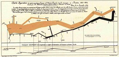
The tradition of data mapping has been popularized through Edward Tufte’s beautiful books (e.g., The Visual Display of Quantitative Information, 1983). Interestingly, many accounts of earlier periods of globalization relied on such devices; there is a long tradition of using maps to tell a multilayered story encompassing time and space, exemplified by the work of Charles Joseph Minard:
Maps are far from neutral representations of a reality. In fact, our understanding of globalization is shaped by the cartographic politics and conventions that define our image of the globe. But mapping has the advantage of requiring an explicit definition of geographical limits, foci, and units of analysis. With the development of computer graphics and GIS technology, the advantages of maps can be expanded through the addition of data layers that allow ever increasing levels of complexity. Despite the epistemological dangers inherent in mapping, no other technique so effectively and efficiently captures masses of data and relational positions.
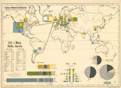
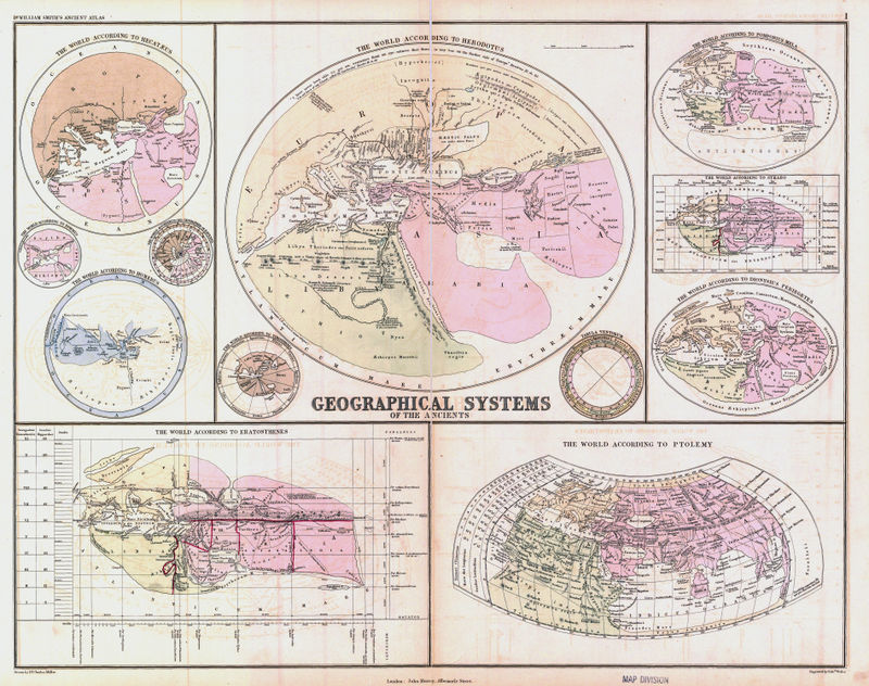
Historical Maps
The Princeton University Geosciences and Map Library has digitized a large collection of historical maps, such as the selections in this section. To see all the details of the original, click on the map to view its description page, click again to view the image file, and then use your browser’s zoom functions to see all the details.

American Express Company, New York, circa 1900
John Murray, London, 1874
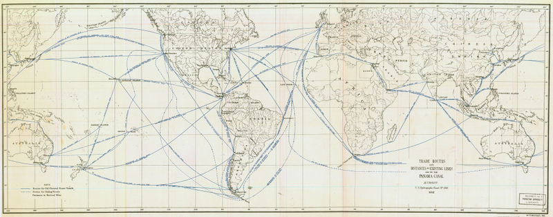
U.S. Hydrographic Chart, 1912
External links
- Mapping History Project (American and European History)
- Watersheds of the World (archive of former location)
- Globalis — includes interactive world maps and data that draw on statistics from the Human Development Report 2003
- Exploring Globalization — San Antonio College
- visitors can view “a large number of layers of demographic, political, economic, and cultural phenomena” using ESRI’s ArcIMS (Internet Map Server)
Other Resources
See also
- INA (International Networks Archive) Infographics
- MG/Maps/Gallery — galleries of maps of potential interest
- Map Category Queries