Caption
Marschroute der Cholera, der verheerendsten Krankheit des 19ten Jahrhunderts.
Literally: Marching Routes of Cholera, the most devastating illness of the 19th Century.
Summary
This world map, which was published in 1849, shows “cholera on the march”. It was one of the first published maps to show the transmission of a disease on a global scale.
The cholera transmission map is an inset map in a larger work that also includes maps on elephantiasis, small pox, and consumption.
This larger map may be the oldest extant map to show the global distribution of disease.
Details
Some of the main transmission routes shown on the map are as follows:
- Calcutta (1817) – Canton (1820) – Peking (1821)
- Calcutta (1817) – Sumatra (1819) – Java (spelled Djava) (1819-23)
- Calcutta (1817) – Lahore (1819 and 1828) – Kabul (1829) – Khiwa (1829) – Kasan (1830) – Archangel 1831
- Bombay (1818) – Ceylon (1819) – Mauritius/Bourbon (1819)
- Bombay (1818) – Basra (1821) – Eastern Mediterranean (1823) – Cairo (1831) – Darfur (n.d.)
- Berlin – Scotland (1831)
- London – New York 1831
- London – New Orleans 1831
Note on Priority
Frank A. Barrett argues that the first world map of human disease was created in 1792 by the German physician L.L. Finke. He also points out that another German physician, Friedrich Schnurrer, presented a world disease map in 1827. Schnurrer’s map attempted to show the world distribution of yellow fever, plague and cholera.
Brigham’s 1832 A Treatise on epidemic cholera includes a map that effectively shows the progress of cholera throughout the world, though it is not a complete world map.
References
Frank A. Barrett (2000).  Finke’s 1792 map of human diseases: the first world disease map?DOI. Social Science & Medicine Volume 50, Issues 7-8, 1 April 2000, Pages 915-921.
Brigham, A. (1832) A treatise on epidemic cholera. Hartford: H. and F. J. Huntington.
Source
The cholera transmission map is an inset in Planiglob Zur Ubersicht der Geographischen Verbreitung Der Vornehmsten Krankheiten, in
Dr. Heinrich Berghaus’ Physikalischer Atlas oder Sammlung von Karten, 1849.
Source
The inset map is derived from the image in the David Rumsey Collection [1].
The map is also available online from the Harvard University Library [2].
Copyright status
The David Rumsey image is Copyright © 2000 by Cartography Associates.
Licensing
The two-dimensional work of art depicted in this image is in the public domain in the United States and in those countries with a copyright term of life of the author plus 100 years. This photograph of the work is also in the public domain in the United States (see Bridgeman Art Library v. Corel Corp.).
Collection
Transmission Routes of Cholera (1817-1831)
|
The Progress of the Spasmodic Cholera, 1832
|
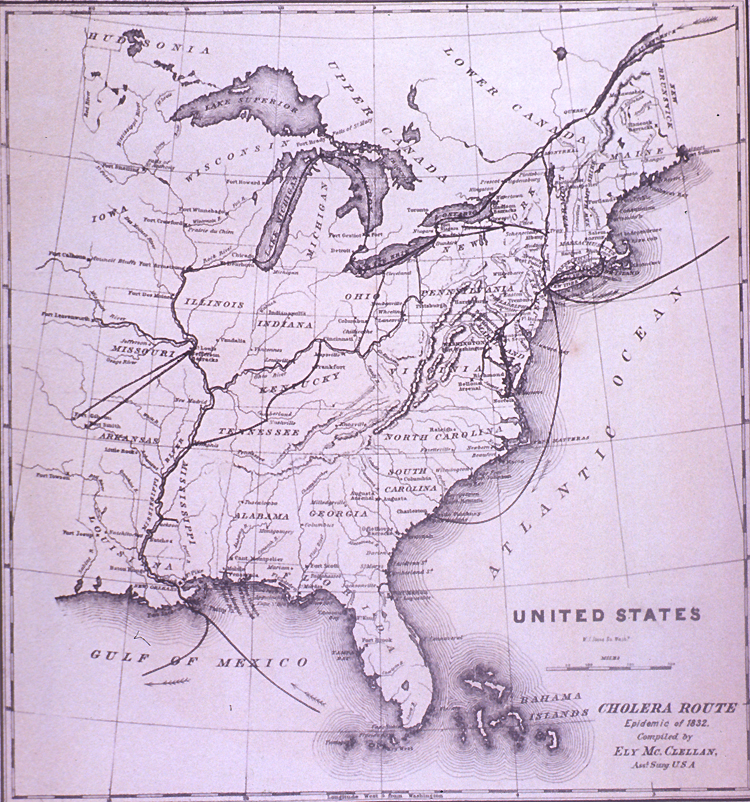
United States Cholera Route – Epidemic of 1832
|
Broad Street Outbreak of Cholera, London, 1854
|
The Geographical Distribution of Health and Disease, 1856
|
The March of Cholera in 1865
|
The Diffusion of Cholera in the United States in 1866
|
Diffusion of Cholera in Eastern Africa, 1864-1871
|
Cholera Diffusion in Zanzibar c. 1869
|
Historical cholera pathways in 1817-1823 and 1863-1869
|
Routes of Asiatic Cholera (1885)
|
Network of cholera diffusion in India, c1931-1953
|
|
|
|


.jpg)


![[1]](http://www.nlm.nih.gov/exhibition/cholera/images/a028419.jpg)