Category Archives: Restricted

Southeast Asia – An Area of Traditional Chinese Immigration, 14th-19th Centuries

Caption

Southeast Asia – An Area of Traditional Chinese Immigration

Summary

Map shows Chinese immigration to Southeast Asia.

Source

The Penguin Atlas of Diasporas. By Gerard Chaliand and Jean-Pierre Rageau. Maps by Catherine Petit. Penguin Books U.S.A. Inc., 1995. (p. 131)

Copyright

© 1995 Gerard Chaliand and Jean-Pierre Rageau

Settlements in Ancient Greece

Caption

Settlements in Ancient Greece

Summary

This map of ancient Greece shows ancient coastlines and roads, as well as tombs and fortifications.

Source

Geoffrey Barraclough. Times Atlas of World History (p. 67).

Times Books Division of Harper Collins Publishers, London. 4th edition, 1993.

GIS Library. Scanned at 400dpi, digitized at 300dpi.

Copyright

Geoffrey Barraclough.

This is a copyrighted work. Its use on QED is under the “Fair Use” rule.

Representation at Vatican II (1962-65)

Caption

Representation at Vatican II

Summary

Map shows number of delegates to Vatican II by country, and countries with a Roman Catholic majority population, 1962-1965.
This is a copyrighted work. Its use on QED is under the “Fair Use” rule..

Source

The MacMillan Atlas History of Christianity (p. 152)

By Franklin H. Littell. Cartography by Emanuel Hausman.

Copyright

© 1976 Maps and plans copyright by Carta Ltd. Text copyright Macmillan Publishing Co., Inc.

Routes of Maritime Trade – E Ware Pottery

Caption

Routes of Maritime Trade – E Ware Pottery

Summary

Shows Routes of Maritime Traffic along the Severn and Southern coasts of Ireland and Britain, indicating Primary and Secondary Voyages and Pottery Sites.

Source

Communication and Commerce Along the Western Sealanes – AD 400-800 (p. 99)

BAR International Series 654, Hadrian Books Ltd., England, 1996.

Copyright

Jonathan M. Wooding .

This is a copyrighted work. Its use on QED is under the “Fair Use” rule.

Reorganization of Europe Napoleon

Caption

The reorganization of Europe brought about by Napoleon, 1812

Summary

Political alliances in 1811 (Post-Napoleon), showing Napoleon’s allies and opponents, as well as the linage of the Bonapartes.

Source

The Penguin Atlas of World History Vol. 2 (p. 26)

Copyright

© 2003 Penguin

Representation at Uppsala Assembly of World Council of Churches 1968

Caption

Representation at Uppsala Assembly of World Council of Churches

Summary

Map shows countries with Protestant majority, and number of churches represented at WCC meeting by country, 1968.
This is a copyrighted work. Its use on QED is under the “Fair Use” rule..

Source

The MacMillan Atlas History of Christianity (p. 152)

By Franklin H. Littell. Cartography by Emanuel Hausman.

Copyright

© 1976 Maps and plans copyright by Carta Ltd. Text copyright Macmillan Publishing Co., Inc.

Regional Trade Agreements, 2005

Caption

Regional Trade Agreements

Summary

This color-coded map of the world shows existing regional trade agreements in 2005.

Legend indicates:

  • Yellow: APEC – Asia Pacific Economic Cooperation
  • Moss Green: APEC & NAFTA (North American Free Trade Agreement)
  • Olive Drab: ASEAN – Association of Southeast Asian Nations
  • Tea Green: ASEAN & APEC
  • Cardinal: CEFTA – Central European Free Trade Agreement
  • Orange: ECOWAS – Economic Community of West African States
  • Royal Blue: EU – European Union
  • Periwinkle: EU & CEFTA
  • Wisteria: MERCOSUR – Southern Common Market
  • Bondi Blue: SACU – Southern African Customs Union
  • Pink: SAPTA – South Asian Preferential Trade Agreement

An explanation of the importance of, and basic differences between, contemporary trade agreements is also provided.

Source

National Geographic Atlas of the World, Eigth Edition. Published by the National Geographic Society. Prepared by National Geographic Maps for The Book Division, 2005.

Copyright

© 2005 National Geographic Society. All rights reserved.

Series

This map is one in a series:


Purchasing Power Map of Europe, 1962

Caption

Purchasing Power Map of Europe – The Chase Manhattan Bank

Summary

This color-coded map shows per capita income estimates for 450 official geographic subdivisions in all 17 Western European countries, based on the Chase Manhattan’s Purchasing Power Survey of 1962. National currency values were converted to U.S. dollars. Map offers chart of values for each country: population, total income in millions, and per capita income.

Source

This map is Map Number 6053 in the collection of copyrighted maps of the Geosciences and Map Library, Fine Hall (B level), Princeton University..

Copyright

The Chase Manhattan Bank

Railways, Minerals and the Occupation of Australia in the 19th and 20th centuries

Caption

Railways, Minerals and the Occupation of Australia in the 19th and 20th centuries.

Summary

This map of Australia shows areas occupied by 1850 and by 1890, the extension of the railway network, and the location of minerals, blast furnaces, penal settlements, and other population centers.

Source

Geoffrey Barraclough. Times Atlas of World History (p. 233).

Times Books Division of Harper Collins Publishers, London. 4th edition, 1993.

GIS Library. Scanned at 400dpi, digitized at 300dpi.

Copyright

Geoffrey Barraclough.

This is a copyrighted work. Its use on QED is under the “Fair Use” rule.

Pourcentage des importations en provenance des États-Unis

Caption

Pourcentage des importations en provenance des États-Unis
(Percentage of Imports from the United States)

Summary

Color-coded map shows percentages of imports of U.S. origin in European, African, and Asian countries in the late 1990s.

This is a copyrighted work. Its use on QED is under the “Fair Use” rule.

Source

Atlas des ɉtats-Unis – Les paradoxes de la puissance. By Philippe Lemarchand, ed Atlande et complexes, Bruxelles, 1997. (p. 179)

Copyright

© 1997 Philippe Lemarchand

Principal European trade routes in the first century AD

Caption

Map 5. Principal European trade routes

Summary

Map shows main trade routes in Europe during the first century of the Common Era.

Source

The Ancient Amber Routes and the Geographical Discovery of the Eastern Baltic (p. 63).

By Arnolds Spekke (Mag. Phil., Dr. Phil., formerly Professor of the University of Latvia).

Published by M. Goppers (Zelta Abele – The Golden Appletree), Stockholm, 1957.

Copyright

Arnolds Spekke, 1957. Originally from Sir Mortimer Wheeler, Rome Beyond the Imperial Frontiers, London 1954.

Political regimes, 2005

Caption

Conflict and Terror: Political regimes

Summary

In this map countries are colored according to their political regime, indicating a correlation with the upsurge of terrorist intentions.

Legend indicates:

  • Medium purple: Democratic regime
  • Coral pink: Autocratic regime
  • Tangerine yellow: Anocratic regime

Source

National Geographic Atlas of the World, Eigth Edition. Published by the National Geographic Society. Prepared by National Geographic Maps for The Book Division, 2005, page 17.

Copyright

© 2005 National Geographic Society. All rights reserved.

Series

This map is one in a series:


Population and Resources, 1998

Caption

Population and Resources, 1998

Summary

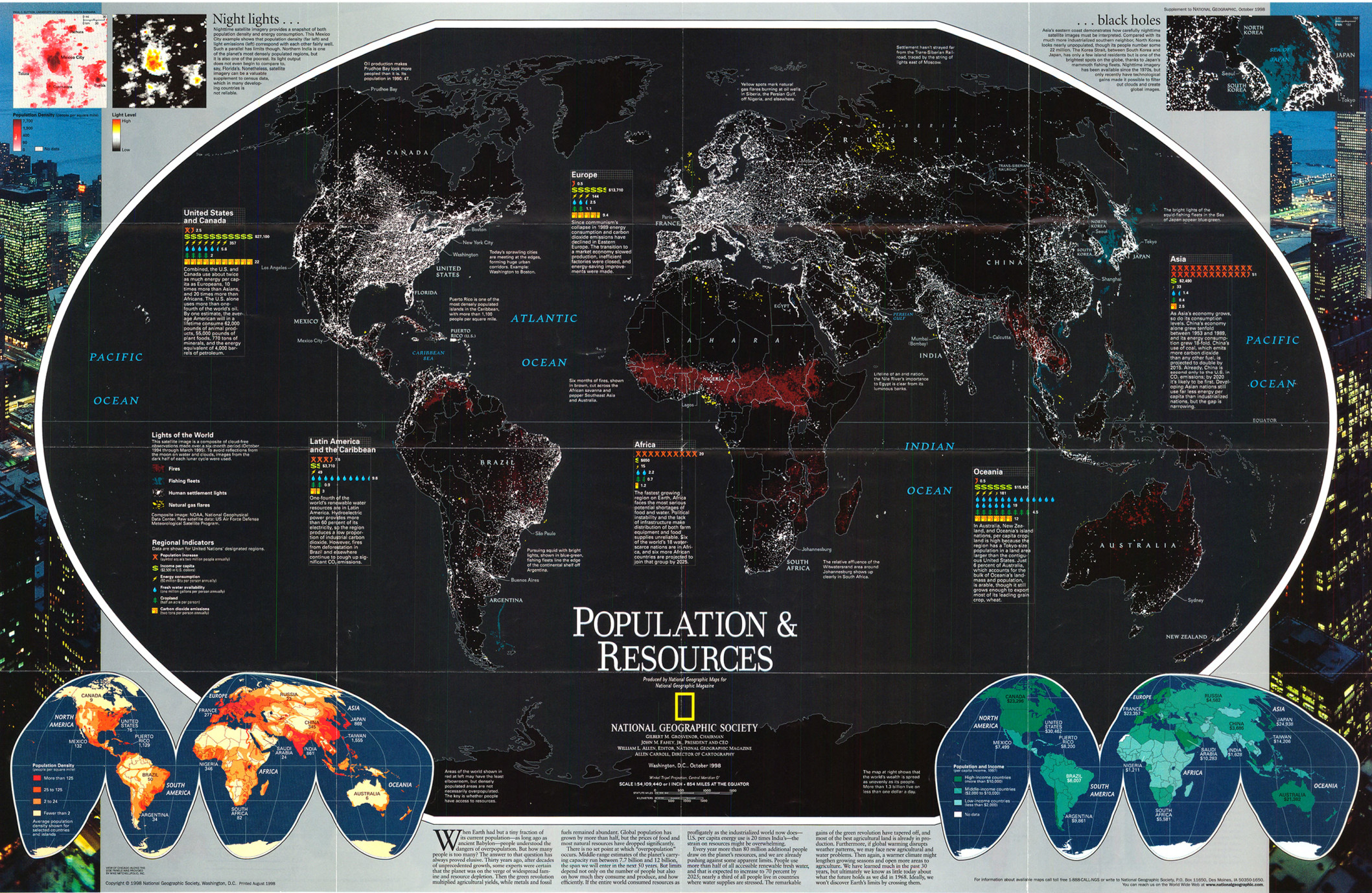
The main map on this poster is based on a satellite image showing the view of the world at night.
The map is colored to distinguish between fires, fishing fleets, human settlement lights,
and natural gas flares.

Two additional maps show:

  • “Population Density” (bottom left) showing people per square mile.
  • “Population and Income” (bottom right) showing per capita income in 1997.

Regional indicators for Africa, Asia, Europe, Latin America and the Caribbean, Oceania, and United States and Canada show:

  • Population increase (symbol equals two million people annually)
  • Income per capita (2,500 in U.S. dollars)
  • Energy consumption (50 million cal. per person annually)
  • Fresh water availability (one million gallons per person annually)
  • Cropland (half an acre per person)
  • Carbon dioxide emissions (two tons per person annually)

Source

Produced by National Geographic Maps for National Geographic Magazine, “Millennium in Maps: Population,” Washington, D.C., 1998.

This map is in the collection of copyrighted maps of the Geosciences and Map Library, Fine Hall (B level), Princeton University.

Call number: G3201.E29.1998.N3 (b)

Copyright

© 1998 National Geographic Society, Washington, D.C.

Series

This map is one in a series:


Persecution of Central European Jews in the Seventeenth Century

Caption

Persecution of Central European Jews in the Seventeenth Century

Summary

Map shows the Jewish diaspora in the 17th Century away from the Kingdom of Poland and the “”Council of Four Lands.”” It also demarcates the main area affected by the Chmielnicki’s massacres (1648-1651, and the main Jewish communities in Poland.

Source

The Penguin Atlas of Diasporas. By Gerard Chaliand and Jean-Pierre Rageau. Maps by Catherine Petit. Penguin Books U.S.A. Inc., 1995. (p. 41)

Copyright

© 1995 Gerard Chaliand and Jean-Pierre Rageau

Petroleum Refineries – Petroleum Movements by Sea, 1962

Caption

Petroleum Refineries – Petroleum Movements by Sea, 1962

Summary

World map shows Refinery Production by Regions and Petroleum Movements by Sea. Oxford Projection.

Source

Oxford Economic Atlas of the World (p. 69)

Prepared by the Economist Intelligence Unit and the Cartographic Department of the Clarendon Press, Third Edition, 1965.

Copyright

Oxford University Press.

This is a copyrighted work. Its use on QED is under the “Fair Use” rule.

Parts de Marché des États-Unis

Caption

Parts de Marché des ɉtats-Unis
(United States Foreign Exports)

Summary

Color-coded map shows US foreign exports by country or region (see pie chart) in the late 1990s.

This is a copyrighted work. Its use on QED is under the “Fair Use” rule.

Source

Atlas des ɉtats-Unis – Les paradoxes de la puissance. By Philippe Lemarchand, ed Atlande et complexes, Bruxelles, 1997. (p. 178)

Copyright

© 1997 Philippe Lemarchand

Peacebuilding, 2005

Caption

Conflict and Terror: Peacebuilding

Summary

In this map countries are colored according to their peace-building capacity. Such capacity is asserted to be partially determined by internal factors such as the successful management of self-determination groups, and external factors such as the spillover of neighboring countries’ conflicts.

Legend indicates:

  • Falu red: High
  • Medium carmine: Moderate
  • Old rose: Low

Source

National Geographic Atlas of the World, Eigth Edition. Published by the National Geographic Society. Prepared by National Geographic Maps for The Book Division, 2005, page 17.

Copyright

© 2005 National Geographic Society. All rights reserved.

Series

This map is one in a series:


Partition of Africa 1880 – 1914

Caption

Partition of Africa, 1880 – 1914

Summary

“Before 1880, the European presence in Africa was largely the remains of early exploration by old imperialists and did not penetrate the heart of the continent. By 1914, the occupying powers included most large European states; only Liberia and Abyssinia remained independent.” [book] Second in a series of maps showing the change in colonial Africa in the 19th and 20th centuries.

Source

Donald Kagan et al. The Western Heritage Since 1300. (p. 890)

Prentice Hall [Pearson]

Copyright

© 2004 Prentice Hall [Pearson]

Palestinians in the Near East

Caption

Palestinians in the Near East

Summary

Map shows Palestinian routes of dispersion, and the main Diaspora within the Near East.

Source

The Penguin Atlas of Diasporas. By Gerard Chaliand and Jean-Pierre Rageau. Maps by Catherine Petit. Penguin Books U.S.A. Inc., 1995. (p. 176)

Copyright

Gerard Chaliand and Jean-Pierre Rageau

Part des exportations à destination des États-Unis

Caption

Part des exportations à destination des ɉtats-Unis
(Percentage of Exports to the United States)

Summary

Color-coded map shows percentages of exports to the U.S. from African, European and Asian countries in the late 1990s.

This is a copyrighted work. Its use on QED is under the “Fair Use” rule.

Source

Atlas des ɉtats-Unis – Les paradoxes de la puissance. By Philippe Lemarchand, ed Atlande et complexes, Bruxelles, 1997. (p. 181)

Copyright

© 1997 Philippe Lemarchand

Ottoman Expansion 1362-1402 A.D. The First Conquest of Rumelia and Anatolia

Caption

Ottoman Expansion 1362-1402 A.D. The First Conquest of Rumelia and Anatolia

Summary

This map illustrates the expansion of the Ottoman realm in Anatolia and Rumelia by showing their lines of conquest, routes of colonization, and raids.

Legend indicates:

  • Trade routes to Bursa
  • Lines of Ottoman conquest
  • Ottoman raids
  • Routes of colonization by Turkish settlers
  • Raids and attacks by opponents of the Ottomans

Rumelian Battles:

  • 1371 Cirmen: Ottomans vs. Serbian princess
  • 1387 Plosnik: Serbians and Bosnians vs. Ottomans
  • 1389 Kosovo: Murasd vs. Serbians and Bosnians
  • 1393 Arges: Bayezid vs. Mircea of Wallachia
  • 1396 Nicopolis: Bayezid vs. Franco-Hunharian Crusade
  • Ozbek

Anatolian Battles:

  • 1393 Akcay plain: Timurtas (Bayzid’s general) vs. Alauddin of Karaman
  • 1393 Corum: Burhanuddin of Eratna vs. Bayezid
  • 1402 Curbuk-ova (Ankara): Timur vs. Bayezid

Source

An Historical Atlas of Islam – Atlas Historique de l’Islam, Second Edition. Edited by Hugh Kennedy, Tuta sub Aegide Pallas 1683,
Brill, Leiden-Boston-Koeln, 2002, page 48.

Cartography by Marc Bel, Peter van der Donck.

Copyright

© 2002 Koninklijke Brill NV, The Netherlands. All rights reserved.

Series

This map is one in a series:


Palestinian Refugees after the 1949 Arab-Israeli War

Caption

Palestinian Refugees after the 1949 Arab-Israeli War.jpg

Summary

Map shows the main Arab exodus routes after the Arab-Israeli war, and the Arab-majority cities and regions from which they emigrated.

Source

The Penguin Atlas of Diasporas. By Gerard Chaliand and Jean-Pierre Rageau. Maps by Catherine Petit. Penguin Books U.S.A. Inc., 1995. (p. 174)

Copyright

Gerard Chaliand and Jean-Pierre Rageau

Northern Europe, 1200 to 1300

Caption

Northern Europe, 1200 to 1300

Summary

This map shows the increasing diffusion and spread of artistic styles and mediums in Northern Europe during the 13th Century. While some styles stuck close to their origins, while other cases, such as the enamels enamels

from Limoges and the manuscripts from East Anglia (eastern England), found a bigger market for themselves outside their regions. .

Source

Atlas of World Art (p. 112)
Oxford University Press

Copyright

© 2004 Laurance King Publishing

North America in 1763

Caption

North America in 1763

Summary

“In the year of the victory over France, the English colonies lay among the Atlantic seaboard. The difficulties of organizing authority over the previous French territory in Canada and west of the Appalachian Mountains would contribute to the coming of the American Revolution.” [book].

Source

Donald Kagan et al. The Western Heritage Since 1300. (p. 573)

Prentice Hall [Pearson]

Copyright

© 2004 Prentice Hall [Pearson]

Nationalities within the Hapsburg Empire

Caption

Nationalities within the Hapsburg Empire

Summary

“The patchwork appearance reflects the unusual problem of the numerous ethnic groups that the Habsburgs could not, of course, meld into a modern national state. Only the Magyars were recognized in 1867, leaving nationalist Czechs, Slovaks, and the others chronically dissatisfied.” [book].

Source

Donald Kagan et al. The Western Heritage Since 1300. (p. 799)

Prentice Hall [Pearson]

Copyright

© 2004 Prentice Hall [Pearson]

Nationalism and Neo-Vernacularism, 1800-1900

Caption

Nationalism and Neo-Vernacularism, 1800-1900

Summary

This map presents the development of ethnic nationalism as a result of the expansion of the Austro-Hungarian Empire, the Ottoman Empire and “westernization”” in Eastern Europe in the late 19th and early 20th Century. On this map, the strength of ethnic and cultural resilience is illustrated by the multitude of languages dominantly used in different regions, not necessarily bound to borderlines, as well as the development and maintenance of folk art and customs. .

Source

Atlas of World Art (p. 238)
Oxford University Press

Copyright

© 2004 Laurance King Publishing