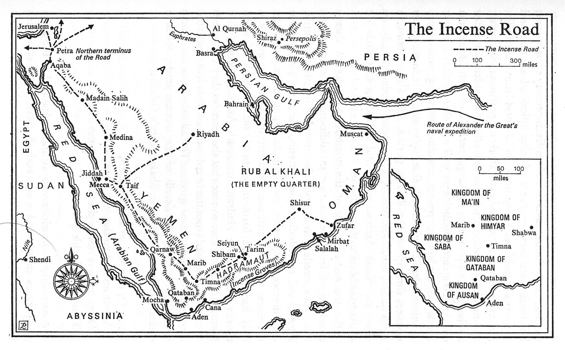
Category Archives: Restricted

The Incense Road in Greco-Roman Times

Caption

The Incense Road in Greco-Roman Times

Summary

Map shows Main and Secondary Incense Roads, its Main Connecting Land Routes, and the sea Spice Route in Greco-Roman Times.

Source

To the Ends of the Earth: The Great Travel and Trade Routes of Human History (p. 168)

Facts on File Publications, New York and Oxford, 1984.

Copyright

Irene M. Franck and David M. Brownstone.

This is a copyrighted work. Its use on QED is under the “Fair Use” rule.

The Incense Road

Caption

The Incense Road

Summary

Shows the Incense Road and the Route of Alexander the Great’s naval Expedition.

Source

Samarkand and Beyond: A History of Desert Caravans (p. 45)

Constable and Company Ltd., Great Britain, 1977.

Copyright

James Wellard.

This is a copyrighted work. Its use on QED is under the “Fair Use” rule.

The Inca Royal Road

Caption

The Inca Royal Road

Summary

Map shows the Main Inca Roads and the approximate borders of the Inca Empire.

Source

To the Ends of the Earth: The Great Travel and Trade Routes of Human History (p. 158)

Facts on File Publications, New York and Oxford, 1984.

Copyright

Irene M. Franck and David M. Brownstone.

This is a copyrighted work. Its use on QED is under the “Fair Use” rule.

The Holy Roman Empire about 1618

Caption

The Holy Roman Empire about 1618

Summary

“On the eve of the Thirty Years’ War, the Holy Roman Empire was politically and religiously fragmented, as revealed by this somewhat simplified map. Lutherans dominated the north and Catholics the south; Calvinists controlled the United Provinces and the Palatinate and were important in Switzerland and Brandenburg.” [book].

Source

Donald Kagan et al. The Western Heritage Since 1300. (p. 410)

Prentice Hall [Pearson]

Copyright

© 2004 Prentice Hall [Pearson]

The Holy Crusades

Caption

The Holy Crusades

Summary

Map shows regions by dominant religion, principal crusade routes, and areas of anti-Jewish riots in eastern Mediterranean and surrounding lands, 11th and 12th Centuries.
This is a copyrighted work. Its use on QED is under the “Fair Use” rule..

Source

The MacMillan Atlas History of Christianity (p. 38)

By Franklin H. Littell. Cartography by Emanuel Hausman.

Copyright

© 1976 Maps and plans copyright by Carta Ltd. Text copyright Macmillan Publishing Co., Inc.

The Great North Road

Caption

The Great North Road

Summary

Map Shows the Main Roman North Road, the Modern Great North Road and the Route Uncertain. It additionally indicates other streets and Main Connecting Roads.

Source

To the Ends of the Earth: The Great Travel and Trade Routes of Human History (p. 128)

Facts on File Publications, New York and Oxford, 1984.

Copyright

Irene M. Franck and David M. Brownstone.

This is a copyrighted work. Its use on QED is under the “Fair Use” rule.

The Great Migration from Ireland to New York and England

Caption

The Great Migration

Summary

Map shows mass emigration of Irish first between 1840 and 1860, then in 1880-1890, almost exclusively to the United States (by 1920, 4.5 million).

Source

The Penguin Atlas of Diasporas. By Gerard Chaliand and Jean-Pierre Rageau. Maps by Catherine Petit. Penguin Books U.S.A. Inc., 1995. (p. 158)

Copyright

Gerard Chaliand and Jean-Pierre Rageau

The Grand Trunk Road in 19th Century India

Caption

The Grand Trunk Road in 19th Century India

Summary

Map Shows Grand Trunk Road and Other Main Connecting Routes.

Source

To the Ends of the Earth: The Great Travel and Trade Routes of Human History (p. 186)

Facts on File Publications, New York and Oxford, 1984.

Copyright

Irene M. Franck and David M. Brownstone.

This is a copyrighted work. Its use on QED is under the “Fair Use” rule.

The Fuelwood Situation in Developing Countries, 1981

Caption

The Fuelwood Situation in Developing Countries

Summary

This multilingual map of developing countries uses colors to classify
regions according to the fuelwood
situation in relation to present (1981) and foreseeable needs.
Regional population densities are also indicated.

Legend (in English, French, Spanish, and Arabic):

  • Satisfactory situation: resources considerably exceed present and foreseeable needs.
  • Satisfactory situation: but decreasing resources could become inadequate, at least locally, in relation to requirements in the foreseeable future.
  • Areas of prospective deficit: present fuelwood resources higher than requirements but evolving toward a crisis situation in 2000.
  • Areas in a deficit situation: present fuelwood resources are below requirements, obliging the population to overexploit.
  • Acute scarcity: fuelwood resources have been so reduced that the population is no longer able to ensure a minimum supply.
  • Desert and sub-desert areas in a scarcity situation with very few resources and low population.

Source

Produced by FAO. First Edition Cartographic Design: H. Engeler.
Printed in Firenze, Italy, 1981.

This map is in the collection of copyrighted maps of the Geosciences and Map Library, Fine Hall (B level), Princeton University.

Call number: G3201.K6.1981.F6

Copyright

© FAO, 1981

The Genocide of the Armenians in 1915-1916

Caption

The Genocide

Summary

Color-coded map shows the presence and population -in thousands- of Armenians in the districts of the Ottoman and Russian empires before their deportation (also indicated) and genocide.

Source

The Penguin Atlas of Diasporas. By Gerard Chaliand and Jean-Pierre Rageau. Maps by Catherine Petit. Penguin Books U.S.A. Inc., 1995. (p. 84)

Copyright

© 1995 Gerard Chaliand and Jean-Pierre Rageau

The Fight of Jews from the Medieval West

Caption

The Fight of Jews from the Medieval West

Summary

Color-coded map shows

  • Regions forbidden to Jews:
    • before 1300 (blue)
    • before 1400 (purple)
    • prohibitions varying according to place and time before 1500 (pink)
    • other Catholic countries (yellow)
    • Muslim world circa 1500 (green);
  • Migration:
    • from England in the 8th century (purple arrows)
    • from France – 14th-15th centuries (pink arrows)
    • from the Holy Roman Empire – 14th-15th centuries (blue arrows);
  • Guest communities and centers of new Jewish settlement (black squares);
  • Major Jewish communities in Western Europe (black dots);
  • Other significant Jewish communities (white dots);
  • Slaughter of Jews by the “”Armleder”” in Central Germany -1298-1303- (red star);
  • Slaughter of Jews by “”Rindfleisch”” in Franconia and Alsace (1336-1338) (red star).

Source

The Penguin Atlas of Diasporas. By Gerard Chaliand and Jean-Pierre Rageau. Maps by Catherine Petit. Penguin Books U.S.A. Inc., 1995. (p. 20)

Copyright

Gerard Chaliand and Jean-Pierre Rageau

The Extent of Greece in the 6th Century

Caption

The Extent of Greece in the 6th Century

Summary

Map shows Greek, Phoenician, and Etruscan zones along the Mediterranean and the Black Sea.

Source

The Great Trade Routes, by Jean Duche. International Library, McGraw-Hill Book Company, New York, St. Louis, San Francisco, 1983, (Page 19).

Cooperating Publishers:

  • Collins–Great Britain
  • Flammarion–France
  • McGraw-Hill–United States
  • Schreiber–Germany

Copyright status

©Jean Duche, 1983

The Eurasian Steppe Route and the Silk Road in Mongol Times

Caption

The Eurasian Steppe Route and the Silk Road in Mongol Times

Summary

Map shows Main Steppe Routes, Main Connecting Routes, and Silk Road. It additionally indicates the Varangian and Saracen Routes.

The Silk Road was a main route for the export and import of medicinal products and spices, as well as silk, particularly during Greco-Roman times.

Source

To the Ends of the Earth: The Great Travel and Trade Routes of Human History (p. 94)

Facts on File Publications, New York and Oxford, 1984.

Copyright

Irene M. Franck and David M. Brownstone.

This is a copyrighted work. Its use on QED is under the “Fair Use” rule.

The Expansion of Islam in the 8th 9th and 10th Centuries

Caption

The Expansion of Islam in the 8th 9th and 10th Cents; Autonomous Islamic states, c. 1000, Autonomous Islamic states, c. 1180

Summary

The expansion of Islam in the 8th, 9th and 10th Centuries, followed by the establishment and growth of autonomous Islamic States in 1000 and 1180.

Source

The Penguin Atlas of World History Vol. 1 (p. 136)

Copyright

© May 25, 2004 Penguin

The Empire of Charles V and the Spanish and Austrian Habsburg

Caption

The empire of Charles V, The Spanish and Austrian Hapsburgs

Summary

Charles V’s empire and opposing countries in Europe (1519-1556). The chart shows the linage of the Spanish and Austrian Hapsburgs, including Charles V.

Source

The Penguin Atlas of World History Vol. 1 (p. 236)

Copyright

© May 25, 2004 Penguin

The Empire of Charles V

Caption

The Empire of Charles V

Summary

“Dynastic marriages and simple chance concentrated into Charles’s hands rule over the lands shown here, plus Spain’s overseas possessions. Crowns and titles rained down on him; his election in 1519 as emperor gave him new distractions and responsibilities.” [book].

Source

Donald Kagan et al. The Western Heritage Since 1300. (p. 359)

Prentice Hall [Pearson]

Copyright

© 2004 Prentice Hall [Pearson]

The Economy of the Hellenistic Period

Caption

The economy of the Hellenistic period

Summary

Economic influence, sites of key resources, and trade routes during the Hellenistic Period in North Africa, southern Europe, and Middle East.

Source

The Penguin Atlas of World History Vol. 1 (p. 70)

Copyright

© May 25, 2004 Penguin

The Economic Life of the Roman Empire

Caption

The Economic Life of the Roman Empire – Caravan and Sea Trade Routes

Summary

This map shows trade routes and distribution of certain goods in the Roman Empire at its peak.

Source

Geoffrey Barraclough. Times Atlas of World History (p. 90).

Times Books Division of Harper Collins Publishers, London. 4th edition, 1993.

GIS Library. Scanned at 400dpi, digitized at 300dpi.

Copyright

Geoffrey Barraclough.

This is a copyrighted work. Its use on QED is under the “Fair Use” rule.

The Early Trans-Canada Fur Trade Routes and The Modern Trans-Canada Routes

Caption

The Early Trans-Canada Fur Trade Routes and The Modern Trans-Canada Routes

Summary

First map Shows Main Trans-Canada Route, and Other Main Fur Trade Routes. Second map shows Modern Trans-Canada Highway, Alaska Highway, and Main Railroads.

Source

To the Ends of the Earth: The Great Travel and Trade Routes of Human History (p. 428)

Facts on File Publications, New York and Oxford, 1984.

Copyright

Irene M. Franck and David M. Brownstone.

This is a copyrighted work. Its use on QED is under the “Fair Use” rule.

The Disintegration of the Roman Empire, AD 300 to 600

Caption

The Disintegration of the Roman Empire, AD 300 to 600

Summary

This map presents the disintegration of Rome caused by nomadic groups such as the Vandals and the Huns during the fourth and fifth centuries. The map is color-keyed in regards to the kingdoms that arose after the fall of the Western Roman Empire in those regions. As religion played a large role in many of the European population’s lives, cities in which important churches reside are marked, like Paris and Rome.
In addition, the Empire of Justinian Justinian of AD 565 is outlined on the map. .

Source

Atlas of World Art (p. 70)
Oxford University Press

Copyright

© 2004 Laurance King Publishing