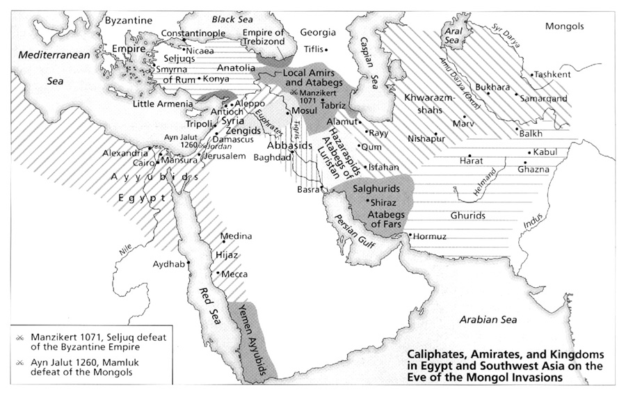
Category Archives: Restricted

British Empire To 1914

Caption

The British Empire to 1914

Summary

Colonies, acquisitions, and trade routes of the British Empire to 1914.

Inset graphs:

  • two pie charts compare the population and area of the British Empire with the population and area of the Earth in 1909.
  • two figures compare the population and area of Great Britain with the population and area of the “colonies”.

Source

The Penguin Atlas of World History Vol. 2 (p. 102)

Copyright

© 2003 Penguin

Caliphates, Amirates, and Kingdoms in Egypt and Southwest Asia on the Eve of the Mongol Invasions 1071-1260 CE

Caption

Caliphates, Amirates, and Kingdoms in Egypt and Southwest Asia on the Eve of the Mongol Invasions

Summary

Map illustrates kingdoms and battle sites on the eve of the Mongol Invasions.
This is a copyrighted work. Its use on QED is under the “Fair Use” rule..

Source

The Cambridge Illustrated History of the Islamic World (p. 33)

J. Bacharach, A Middle East Studies Handbook, Rev. Edn., Cambridge

Copyright

© 1984 J. Bacharach, A Middle East Studies Handbook, rev. edn., Cambridge (p. 63)

British Conquest of India 1753 to 1890

Caption

British Conquest of India 1753 to 1890

Summary

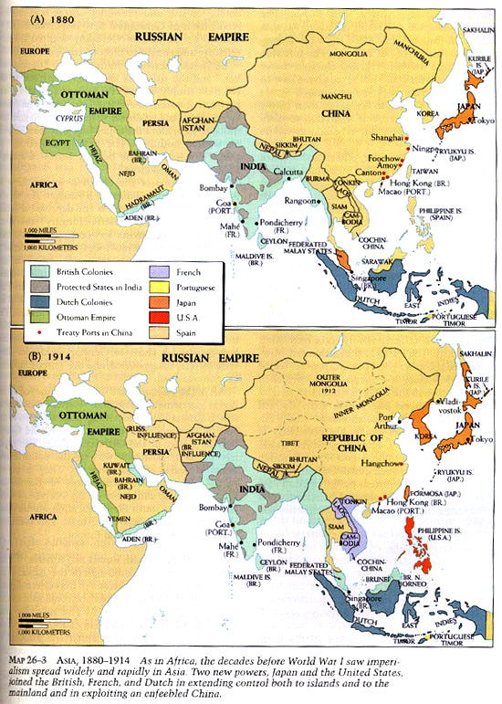
This map displays the British colonization of India from 1753 to 1890. The regions of India have been color-coded according the year in which they were annexed by the British empire. The map also shows the Indian territories which were under Portuguese and French control, the areas most affected by the Indian mutiny of 1857, the cities in which there were major uprisings, the British military campaigns in the area, and the dependant and minor dependant states.

Source

Historical Atlas of the Islamic World (p. 100)

Copyright

Copyright © Oxford University Press, 2004

License

This map is used on this website by permission of Oxford University Press.

The license only allows it to be used in connection with SOC284 and WWS572B at Princeton University during the 2008-9 academic year.

The map appears in Malise Ruthven and Azim Nanji, Historical Atlas of the Islamic World (Oxford University Press, 2004).

Axis Europe 1941

Caption

Axis Europe, 1941

Summary

“On the eve of the German invasion of the Soviet Union, the Germany-Italy axis bestrode most of western Europe by annexation, occupation, or alliance–from Norway and Finland in the north to Greece in the south and from Poland to France. Britain, the Soviets, a number of insurgent groups, and, finally, America, had before them the long struggle of conquering this Axis ‘fortress Europe'”. [book] Map of Axis/Allied powers in Europe in 1941.

Source

Donald Kagan et al. The Western Heritage Since 1300. (p. 1009)

Prentice Hall [Pearson]

Copyright

© 2004 Prentice Hall [Pearson]

Asia, Trade and Culture, 1500-1800

Caption

Asia, Trade and Culture, 1500-1800

Summary

This map shows the major centers of culture and trade in Asia from 1500 to 1800. Sites of courtly art, religious architecture, traditional printmaking and Japanese coloring are noted along with European trading ports and arrows indicating imported European goods to Asia. Islamic trade routes are also marked.
Additionally, predominant religions are indicated by color, along with empires, indicated by different colored lines, during this time frame.
The Inset Map, European Possessions, 1650, shows the territory ruled by the Dutch, Spanish and Portuguese in 1650. .

Source

Atlas of World Art (pp. 192-193).
Oxford University Press

Copyright

© 2004 Laurance King Publishing

Average daily per capita calorie consumption, 2005

Caption

Average daily per capita calorie consumption

Summary

Color-coded world map shows average per capita calorie consumption in the following fashion:

  • Fern Green: High
  • Asparagus Green: Adequate
  • Khaki: Low
  • Buff: Very Low
  • Beige: No data

High caloric intake is mainly seen in North America, much of Europe, Australia, and some parts of South America. Insufficient caloric intake and malnutrition are seen mainly in Sub-Saharan Africa.

Pie charts at the bottom further indicate dietary habits in each continent.

Source

National Geographic Atlas of the World, Eigth Edition. Published by the National Geographic Society. Prepared by National Geographic Maps for The Book Division, 2005.

Copyright

© 2005 National Geographic Society. All rights reserved.

Series

This map is one in a series:


Asia 1880-1914

Caption

Asia, 1880-1914

Summary

“As in Africa, the decades before World War I saw imperialism spread widely and rapidly in Asia. Two new powers, Japan and the United States, joined the British, French, and Dutch in extending control both to islands and to the mainland and in exploiting an enfeebled China. [book] Two maps showing the change from 1880 to 1914 in the Middle East and Southern Asia.

Source

Donald Kagan et al. The Western Heritage Since 1300. (p. 893)

Prentice Hall [Pearson]

Copyright

© 2004 Prentice Hall [Pearson]

Art of West Asia, 3000-2000 BC

Caption

Art of West Asia, 3000-2000 BC

Summary

This map presents the spread of cuneiform Cuneiform from 3000 BC to 2000 BC in Mesopotamia, which is located in today’s Middle East.
Also indicated on the map are places of burials, palaces, ziggurats and schematic female figures. .

Source

Atlas of World Art (p. 40)
Oxford University Press

Copyright

© 2004 Laurance King Publishing

A Restored Israel, 1948-1972

Caption

A Restored Israel

Summary

Map shows Jewish immigration worldwide from 1948 to 1972.
This is a copyrighted work. Its use on QED is under the “Fair Use” rule..

Source

The MacMillan Atlas History of Christianity (p. 162)

By Franklin H. Littell. Cartography by Emanuel Hausman.

Copyright

© 1976 Maps and plans copyright by Carta Ltd. Text copyright Macmillan Publishing Co., Inc.

Artistic Cross-currents in 16th Century Europe

Caption

Artistic Cross-currents in 16th Century Europe

Summary

This map illustrates the influence of religion on art during the 16th Century. While some religions and religious branches thought positively of art, like Catholicism and the Eastern Orthodox, others thought negatively of art like Islam, Calvinism, and Anglican.
Additionally, the map indicates different art mediums found all over Europe, from sculpture to printmaking. The emigration and travel of architects, artists and craftsman is also indicated, along with the destination. .

Source

Atlas of World Art (pp. 154-155).
Oxford University Press

Copyright

© 2004 Laurance King Publishing

Ancient India

Caption

Ancient India

Summary

Map shows sites important to the origins of Buddhism, associated with Buddha’s life or associated with Buddhism over the centuries.
This is a copyrighted work. Its use on QED is under the “Fair Use” rule..

Source

Buddhism: The Illustrated Guide (p. 13)

Kevin Trainor, Oxford University Press, Oxford-New York, 2001.

Copyright

© 2001 Oxford University Press

AmberRoutes

Caption

The Amber Routes in Prehistoric Times

Summary

The map shows the Brenner Route, the Rhône-Saône Route and the Vistula Route, together with the main connecting land and sea routes.

Modern cities are noted for reference.

Source

“To the Ends of the Earth: The Great Travel and Trade Routes of Human History”.
Irene M. Franck and David M. Brownstone.
Published 1984, Facts on File Publications, New York and Oxford.

Copyright status

© 1984

Amber Route through the Middle Danube lands in Prehistory

Caption

Map 6. Amber Route through the Middle Danube lands.

Summary

Map shows amber route in prehistoric times.

Source

The Ancient Amber Routes and the Geographical Discovery of the Eastern Baltic (p. 67).

By Arnolds Spekke (Mag. Phil., Dr. Phil., formerly Professor of the University of Latvia).

Published by M. Goppers (Zelta Abele – The Golden Appletree), Stockholm, 1957.

Copyright

Arnolds Spekke, 1957. Originally from M. Cary, The Geographic Background of Greek and Roman History, Oxford 1949.

Ambassador-Burma Road Early Middle Ages

Caption

The Ambassador’s Road and the Burma Road in the Early Middle Ages

Summary

Map also shows the Silk Road and the maritime Spice Route.

The Silk Road was a main route for the export and import of medicinal products and spices, as well as silk, particularly during Greco-Roman times.

Source

“To the Ends of the Earth: The Great Travel and Trade Routes of Human History”.
Irene M. Franck and David M. Brownstone.
Published 1984, Facts on File Publications, New York and Oxford.

Copyright

Irene M. Franck and David M. Brownstone, 1984.

This is a copyrighted work. Its use on QED is under the “Fair Use” rule.

Amber Route Sites

Caption

Amber Route Sites

Summary

Shows Amber Route and Sites along the Pannonia. The large number of amphorae (a type of ceramic vase with two handles and a long neck) dug up along the Amber Route to date, are characteristic findings of the early period of the Roman Empire. Their sites indicate the trade relations with different provinces. The Italian inhabitants of Pannonia were always able to consume foodstuffs produced in the Mediterranean. In the amphorae transported here, wine, oil, olives and fish sauce were stored.

Source

Roman Amphorae from the Amber Route in Western Pannonia (p. 191)

BAR International Series 386, Great Britain, 1987.

Copyright

Tamas Bezeczky.

This is a copyrighted work. Its use on QED is under the “Fair Use” rule.

Al-Andalus and Al-Maghrib- The Muslim Conquest, 44-732

Caption

Al-Andalus and Al-Maghrib- The Muslim Conquest, 44-732

Summary

This map shows the general conditions of the establishment of Muslim rule in Portugal and Spain. Existing medieval roads inherited from the Roman administration were used by the Umayyads to pursue their conquests.

Legend indicates (with arrows of different colors):

  • Limit of Muslim influence
  • Conquest of ‘Uqba b. Nafi’ 44-9/665-70
  • His raid to the Atlantic
  • Reconquest of Ifrïqiyya (from the Berbers) by Hasan b. al-Nu’man 76-86/695-705

Muslim conquest of Visgothic Spain:

  • Tariq b. Ziyad 92/711
  • Musa b. Nusayr 93/712
  • ‘Abd al-‘Aziz b. Musa 95/714

Attempted Conquest of France:

  • Raids across Pyrenees 94-107/713-725
  • ‘Abd al-Rahman al ghafiqi 114/732

Source

An Historical Atlas of Islam – Atlas Historique de l’Islam, Second Edition. Edited by Hugh Kennedy, Tuta sub Aegide Pallas 1683,
Brill, Leiden-Boston-Koeln, 2002, page 53.

Cartography by Marc Bel, Peter van der Donck.

Copyright

© 2002 Koninklijke Brill NV, The Netherlands. All rights reserved.

Series

This map is one in a series:


Air Communications – Airports and Principal Routes

Caption

Air Communications – Airports and Principal Routes

Summary

Map shows Airports and Principal Air Routes worldwide (1963). It additionally offers a table with information on Cargo and Passenger Air Traffic (1960). Local times are indicated. Modified Gall Projection.

See also MG©Air Communications – Air Routes and Frequencies.jpg.

Source

Oxford Economic Atlas of the World (p. 16)

Prepared by the Economist Intelligence Unit and the Cartographic Department of the Clarendon Press, Third Edition, 1965.

Copyright

Oxford University Press.

This is a copyrighted work. Its use on QED is under the “Fair Use” rule.

Air Communications – Air Routes and Frequencies

Caption

Air Communications – Air Routes and Frequencies

Summary

Map shows Major Air Routes worldwide, a table with Frequencies of Scheduled Flights according to local times, and a Cargo and Passenger Air Traffic table (1956). Modified Gall Projection.

See also MG©Air Communications – Airports and Principal Routes.jpg.

Source

Oxford Economic Atlas of the World (pp. 100-101)

Prepared by the Economist Intelligence Unit and the Cartographic Department of the Clarendon Press, Second Edition, 1959.

Copyright

Oxford University Press.

This is a copyrighted work. Its use on QED is under the “Fair Use” rule.

Africa – Maritime Shipping Routes

Caption

Africa – Maritime Shipping Routes

Summary

Map shows Principal Shipping Routes around Africa with distances in nautical miles. Also indicates direction of currents. Projection: Zenithal Equidistant.

Source

World Atlas of Shipping (p. 79)

Copyright

George Philip & Son Ltd.

This work may still be under copyright and therefore care is required in its use. Its use on QED is under the “Fair Use” rule.

Afghanistan – Land in Crisis, 2001

Caption

Afghanistan – Land in Crisis

Summary

This poster features a satellite view of Afghanistan with topographical information.

There are also three smaller maps:

  • “A Patchwork of Ethnic Minorities,” showing regional ethnolinguistic groups.
Legend:

  • Pashtun
  • Tajik
  • Hazara
  • Aimak
  • Baluchi
  • Kyrgyz
  • Turkmen
  • Nuristani
  • Pamiri
  • Other
  • “Drought and Earthquakes Ravage the Region,” showing the climate-related migrations in the region.
Legend:

  • Drought
  • Drought-related population movement
  • Major earthquake since 1900
  • “Refugees Flee War and Famine,” showing war-related population movement.
Legend:

  • Taliban territories
  • Northern Alliance (United Front)
  • War-related population movement
  • Refugee camp
  • Concentration of displaced people

An essay and a timeline from the First Anglo-Afghan War are also included.

Source

Produced by National Geographic Maps for National Geographic Magazine, Washington, D.C., 2001. Related article by Peter Miller Afghanistan: Land in Crisis.

This map is in the collection of copyrighted maps of the Geosciences and Map Library, Fine Hall (B level), Princeton University.

Call number: MC G7631.C1.2001.N3

Copyright

© 2001 National Geographic Society, Washington, D.C.

20th Century Amsterdam

Caption

20th Century Amsterdam

Summary

This map of Northwest Europe in the 20th Century shows the movement of artists, artistic centers and artist colonies, as well as the line of trench warfare during World War One and imports that came from colonial territories. The arrows on the map not only indicate the movement of specific artists and artists in general, but the movement of Surrealism into France and the “tour”” of Dada Dada in Holland.

Source

Atlas of World Art (p. 278)
Oxford University Press

Copyright

© 2004 Laurance King Publishing