
Summary
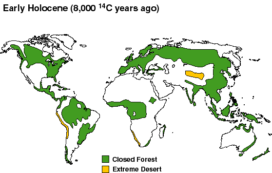
- The first map shows vegetation cover at 8,000 14C years BP (i.e. 8,000 carbon-dating years before the present)
- The second maps shows vegetation cover at 5,000 14C years BP
- The third map shows “present potential” vegetation, the areas of forest and desert that would be present but for human activity. The authors write that “Although it represents a ‘potential’ state, it is nevertheless much as the world would actually have looked about 4,000-3,000 14C y.a., before agriculture became important in modifying vegetation cover in many regions.”
Legend: Closed Forest; Extreme Desert.
Source
http://www.esd.ornl.gov/projects/qen/nerc.html (accessed April 30, 2007)
Adams J.M. & Faure H. (1997) (ed.s), QEN members. Review and Atlas of Palaeovegetation: Preliminary land ecosystem maps of the world since the Last Glacial Maximum. Oak Ridge National Laboratory, TN, USA. http://www.esd.ornl.gov/ern/qen/adams1.html