Kanishkh Kanodia
This essay talks about how maps were politically used in appropriating Patagonia as part of the nation-states of Argentina and Chile in the 19th Century.
During the 19th century, Patagonia had become the locus of overlapping expansionist desires of Argentina and Chile as both nations scrambled to consolidate their states post-independence which had evaded Spanish colonialism. However, since neither nation had a titular authority over the ‘empty spaces’ of Patagonia, each had to uphold the legitimacy of their claim via historical and cartographical proofs. This connection between diplomacy and the geopolitics of excavation and production of knowledge prompted the patronage of state-led expeditions into the unchartered territories of Patagonia and the archives of Europe. This was done with the aim of turning Patagonia into a more recognizable land that can be claimed as an imagined community of both Argentina and Chile.

The explosion of science and knowledge resulted in an effervescence of maps as political tools for assimilating the region as part of the nation-state of Argentina or Chile. Leuenberger and Schnell argue that maps “do not reveal, but produce reality … entailing a shift from ontology (how things are) to ontogenesis (how things become)”. This is done by selectively demarcating spaces and using varying cartographical details to establish a spatial hierarchy over a territory. Therefore, maps should be looked as “socially produced texts” through a lens of who made them, when were they made and what purpose they served. Maps of Patagonia served this purpose as a tool for colonising the mind in the years leading up to and following the signing of the Border Arbitration Treaty of 1881 between Argentina and Chile.
Visual Representation of Patagonia
In the years following independence, no boundary dispute ensued between Argentina and Chile. Even though the Chilean constitution of 1833 extended Chilean boundaries to Cape Horn in the south and the Andes cordillera in the east, Chile was mostly concerned about securing its northern borders. Argentina was mired in its own civil wars that were causing a political fragmentation of the nation.
The border dispute began in 1843, when Chile found its own settlement of Fort Bulnes on the Brunswick Peninsula in an attempt to establish its authority over the Strait of Magellan and the adjoining Patagonia. Chile’s shifting motivation was due to the advent of steam navigation in the Southern Cone in 1840 when two steamships from the Pacific Steamship Navigation Company passed through the Strait instead of going around the Cape of Horn, heightening the economic and strategic value of the Strait. However, Argentina, protested Chile’s settlement because control over Patagonian pampas presented the prospect of massive wealth, horses and loot for the nation. In reality, however, neither nation had any real settlement in Patagonia. By 1840, the limit of Argentinean jurisdiction was the settlement of Carmes des Patagones on the Rio Negro. Fort Bulnes only had 202 souls by 1861; in fact, it was a penal colony, which Perry argues was a “weak foundation for an instrument of empire”. At the same time, the Southward expansion by both nations was hindered by the continued strength of the indigenous communities, creating a “no-man’s land” in Patagonia, the northern limits of which “coincided with the limits of Chilean claim over Patagonia”. Furthermore, both nations lacked a comprehensive understanding of the topography of the inner regions of Patagonia. Even though the coastal areas had been mapped extensively by hydrographic surveys carried out by European expeditions, the understanding of the cordillera or the valleys was still inadequate. Maps reflected this gap between the Argentinean and Chilean claim vis-à-vis their actual authority on ground.

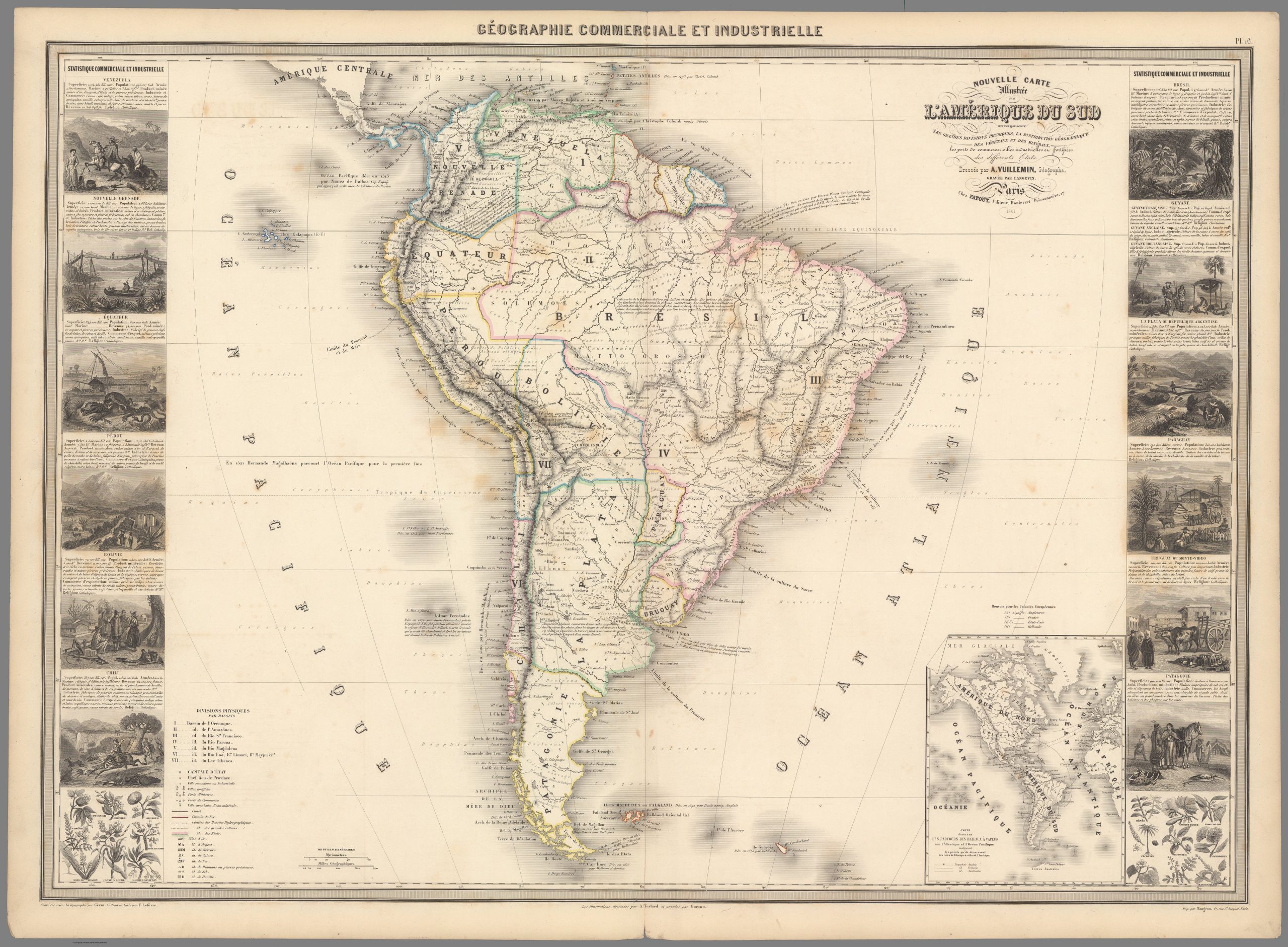
In the maps produced in the West before 1856, the entirety of Patagonia – including Tierra del Fuego and Brunswick Peninsula- is depicted to be independent. The extent of Argentina’s territory ceases at Rio Negro, while Chilean territory roughly extends to Rio Coique (including the island of Chiloe). Moreover, there is no mention of the settlement of Punta Arenas; however, the Argentinean settlement of ‘Carmen’ on the mouth of Rio Negro is recognized. Another striking feature is the contrast of the details of the topographical features – rivers, mountain slopes, and other landforms- between Patagonian inlands (roughly below 40° latitude) and the rest of the subcontinent. The maps complement the literature on the emptiness of Patagonia, demarcating them as void lands waiting to be populated. Moreover, Argentina and Chile relied on European cartographers due to the dearth of cartography on the subcontinent. Therefore, mapping became an important tool in shaping the socio-territorial process of colonising the ‘empty space’ and proving the supremacy of their claim. Subsequently, both nations began to sponsor historical research and expeditions that would compile archival, cartographic and documentary evidence to appropriate Patagonian territory in their nation-state.
From 1823, the Chilean government began to commission foreign nationals to carry out scientific mapping of Chilean territory. Of these, the most consequential studies were produced by Claudio Gay, a French naturalist. Gay published a multi-voluminous ‘Historia física y política de Chile’ in 1854, which had a map that showcased Magellan strait and adjacent areas as part of Chile’s sovereign territory. These set of atlases, regarded as the first national cartographic survey of Chile, used cartographic language to transform the sovereignty of these areas. The Chilean government also commissioned navy officers – including Don Francisco Vidal Gormaz and Don Enrique Simpson- to explore chart and the West Patagonian littoral. With a similar mission, the Argentinean government hired a French naturalist Martin de Moussay, who published ‘Déscription geographique et statistique de l’Argentine’ in 1865.The maps in this atlas showed Patagonia as an Argentinean territory; in fact, in the legend, the cartographer explicitly wrote: “There exists no other points of habitation in Patagonia than Carmen [des Patagones] and the Chilean Colony of Punta Arenas” (translated from French). Interestingly, even though in 1852 Argentina had commissioned the research by Pedreo de Angelis which refuted Chile’s claim over the Strait and Tierra del Fuego, the map by Moussay recognizes the Chilean settlement. However, the acknowledgment of the settlement need not be seen as a concession of sovereignty; in fact, by 1860s Argentinean claim over Patagonia was becoming more insistent as its internal political turmoil was settling. Moussay, however, had never been to Patagonia himself; in fact, Francisco Moreno and Ramón Lista had carried out the most extensive geographic survey of Patagonia for Argentina by traversing the territory in their own expeditions. But even their surveys were unable to penetrate into the “interior and Western ranges of the cordillera”. Nevertheless, the boundary dispute promoted extensive topographical surveys of the previously unchartered territories of Patagonia that produced a conceptual and technical understanding to appropriate Patagonia.


To buttress the voluminous production of scientific information, both nations created their own geographical societies which synthesized the scientific with the legal. In 1873, Chile established its own hydrographic body that mapped the complex archipelago beyond the island of Chiloe. The same year, Foreign Minister Ibáñez appointed the Chilean Minister to France, Carlos Vicuña, to investigate the French and Spanish archives and uncover details of their colonial past to strengthen their claim. Argentina appointed Mariano Balcarce to carry out the same task. In fact, Argentinean government created the Military Geographical Institute and the Argentine Geographical Institute in 1879 to survey the lands of Patagonia, amalgamate the cartographic knowledge with the historical one and contribute to the argumentative support of Argentina
Furthermore, the explosion of knowledge was accompanied by the expansion of their actual presence on the land. By 1870s, Chile had taken possession of the eastern slopes of the Andes, which were separated from Argentinean influence by the pampas and the belligerent Indians. In fact, in the Néquen Valley Chileans had established their own ranches called “Chilecitos”, through which it established strong inter-Andean cattle trade links with the Araucanians, thereby controlling the pampas by exerting influence over its inhabitants. Meanwhile, Argentina extended its authority till Rio Chubut with the establishment of the Welsh colony of Rawson in 1865, the inhabitants of which used Argentinean flags and negotiated extensively with the government in Buenos Aires. Not only did the Welsh inhabitants developed links with the indigenous populations but they also extensively mapped areas of the Chubut Province for the Argentinean government. Furthermore, Argentina also launched a military expedition in 1870s to terminate the threat of the Indians and conquer the land. The campaign itself was designed by the geographer Estanislao Zeaballos and included some prominent Argentinean cartographers.
These geographic-military expeditions not only marked their physical presence in Patagonia, but also purposefully “re-baptized” the lands by changing the existing toponyms of the landforms. If one were to compare the maps of Moussay (Figure 3) with that of Moreno (1899), it is discernible that not only have the new lakes taken the names of Argentinian Ministers but the existing one had also been renames. An example of Lake Buenos Aires, the largest lake in Patagonia, can be instructive in substantiating this point. In the maps before 1873, the lake is referred to as Lake Colu-guape which is an Araucanian term formed from “colu” (earth of brown or reddish colour) and “huapí” (island). However, post-1873, after expeditions led by Moreno and Luis Fortana breached the area the lake became Lake Buenos Aires. Floria also highlights similar processes in the naming of Lake Cinterr and Sierra Zeballos. This act of deliberate renaming and naming of new places after Argentinians presents the discoveries as the conquering of novel uninhabited lands, justifying the expansion of the nation-state under a positivist notion of progress in this rich region. Furthermore, by imposing Argentinian history through an erasure of the indigenous one, it becomes an act of cultural colonisation.

This dynamism of the occupations and military missions on the ground was reflected in the wavering diplomatic demands of Chile and Argentina. In the first diplomatic mission of 1865, Chile would only claim Tierra del Fuego, Magellan Strait and parts of Patagonia for itself; however, by 1871, Foreign Minister Ibáñez staked authority over the entirety of Patagonia, extending till the Atlantic Ocean.In 1875, Chile revised its claim only till Rio Gallegos and in the 1878 Feirro-Sarratea Treaty, it agreed to exercise jurisdiction in the Strait, relinquishing its Atlantic Claim. The inconsistent demands were greatly influenced by the geo-political events of the continent, such as the Paraguayan War and War in the Pacific and the individual whims of the Foreign Ministries on both sides. As a result, the Western maps of these decades do not present a coherent narrative of who possessed Patagonia. Few still showed Patagonia to be a ‘no-man’s land’; others recognized the Western Patagonian littorals (extending till Tierra del Fuego) as part of Chile; some depicted entire Patagonia to be under Chile; and others displayed Patagonia as a part of both nations without any clear land boundary through the Andes. While one could question the influence of these maps in the actual negotiations and policymaking, they are nonetheless reflective of the evolving and complex geo-political situation on the ground. Meanwhile, Argentinian and Chilean authorities continued with their cartographical explorations.


Ultimately, after its brutal military expansion into Patagonia in April 1879, called ‘Conquest of the Desert’, Argentina had formally extended its frontier to Rio Negro and Rio Néquen spanning across the pampas and the eastern slopes of the Andean cordillera, severing the Chilean-Indian links and claiming supremacy in the pampas. This led to the Border Arbitration Treaty of 1881, which granted entire Eastern Patagonia to Argentina and the Strait to Chile. All maps post-1881, including the official ones sponsored by Chilean and Argentinian governments, reflected this change; however, they still greatly differed in the demarcations of the Andean land boundary between Argentina and Chile.


The Treaty sought to demarcate the land boundary according to the “most lofty peaks that divide the waters” based on the assumption that the highest peaks mark the watershed. However, in Patagonia, the drainage patters are more complex due to the influence of glaciers and subterranean water reserves; thus, as detailed knowledge of the region grew, policy-makers realised the blunder of their assumption. As a result, when both nations actually began to demarcate the lands beyond the 40th parallel, Argentina realised that it would benefit if the boundary is drawn with the highest peaks, whereas Chile would profit if the line was drawn based on the drainage patterns. The two maps give a detailed narrative of the demands of each nation between the 40° and 52° latitudes. Moreover, division of Tierra del Fuego proved to contentious since the Andes shift their orientation at that latitude, making the prospect of a land boundary along them to be meagre. The epistemological bodies and forces on both sides of the border mobilized more decisively to settle the object of the dispute to their favour. Being unable to do so amicably, they referred to King Edward VII of Britain to arbitrate, which resulted in the signing of the Pacts of May in 1902, and settled the dispute, only temporarily.
Conclusion
During the late 19th century, maps became an important tool in changing the spatial-territorial imagination of Patagonia. The explosion of scientific, topographic and archival knowledge was synthesized and presented via maps by Argentina and Chile in an effort to make the ‘empty spaces’ of Patagonia more identifiable and definite for their nation-state. However, due to the underdeveloped indigenous organisations, they often had to rely on maps produced in Europe and America to stake their claim over Patagonia. This was accompanied by a series of tense diplomatic and brutal militaristic efforts that culminated in 1881 with the signing of the Broder Arbitration Treaty. The Treaty marked the end of indigenous claim over Patagonia, appropriating the ‘no-man’s land’ into the Argentinian and Chilean nation-state. Despite the temporary settlement, the lack of topographical knowledge of the Andean cordillera ensued the conflict for another two decades. However, any settlement over Patagonia can only be a minor interim in the struggle over territory. Soon, the two nations got embroiled in a power-struggle over the division of the Beagle Channel. Till date, parts of Patagonia, such as the South Patagonian Ice Field, remain uncharted and disputed. Even the advances of the 21st century have been unable to master the Patagonian geography.
Further Readings
Primary Sources
Moreno, Francisco P. “Explorations in Patagonia.” The Geographical Journal 14, no. 3 (September 1899): 241–69. https://www.jstor.org/stable/1774365.
Moreno, Francisco P. “The Chile-Argentine Arbitration.” The Geographical Journal 21, no. 1 (January 1903): 45–50. http://www.jstor.org/stable/1775286.
Moussay, Martin de. Description Géographique Et Statistique De La Confédération Argentine [Material Cartográfico] : Atlas, n.d. http://bdh.bne.es/bnesearch/biblioteca/Description géographique et statistique de la Confédération Argentine : Atlas/qls/Moussy, V. Martin de/qls/bdh0000000379;jsessionid=160960D500B082B4482E2B05E454CD0A
Steffen, Hans. “The Patagonian Cordillera and Its Main Rivers, between 41° and 48° South Latitude.” The Geographical Journal 16, no. 1 (July 1900): 14–38. https://www.jstor.org/stable/1774297.
Secondary Sources
Bowen, E. G. “The Welsh Colony in Patagonia 1865-1885: A Study in Historical Geography.” The Geographical Journal 132, no. 1 (March 1966): 16–27. https://www.jstor.org/stable/1793048.
Dodds, Klaus-John. “Geopolitics, Cartography and the State in South America.” Political Geography 12, no. 4 (July 1993): 361–81.
Estefane, Andrés. “Imperial Uncertainties and Republican Conflicts Archives, Diplomacy, and Historiography in Nineteenth-Century Chile.” Early American Studies: An Interdisciplinary Journal 11, no. 1 (2013): 192–207. https://doi.org/10.1353/eam.2013.0005.
Floria, Pedro Navarro. “Landscapes of an Uncertain Progress: Northern Patagonia in Argentine Scientific Journals (1876–1909).” Journal of Latin American Cultural Studies: Travesia 16, no. 3 (November 9, 2007): 261–83. https://doi.org/http://dx.doi.org/10.1080/13569320701682476.
“La Hidrografía En Chile – Memoria Chilena.” Memoria Chilena: Portal, n.d. http://www.memoriachilena.gob.cl/602/w3-article-100648.html.
Leuenberger, Christine, and Izhak Schnell. “The Politics of Maps: Constructing National Territories in Israel.” Social Studies of Science 40, no. 6 (December 2010): 803–42. https://www.jstor.org/stable/40997773.
Melo, Walter, Facundo Scordo, Gerardo Perillo, and Maria Piccolo. “Identification of the ‘Coluguape’ Lake in Historical Cartography (1775-1898): Its Connection to the Buenos Aires-General Carrera Lake and Musters-Colhué Huapi Lake System.” Magallania, January 2017. https://www.researchgate.net/publication/318323761.
“Memoria Chilena.” Representaciones cartográficas de Chile durante el siglo XIX – Memoria Chilena, Biblioteca Nacional de Chile, n.d. http://www.memoriachilena.gob.cl/602/w3-article-582424.html.
Perry, Richard O. “Argentina and Chile: The Struggle for Patagonia 1843-1881.” The Americas 36, no. 3 (January 1980): 347–63. https://www.jstor.org/stable/981291.
Rauch, George v. Conflict in the Southern Cone: The Argentine Military and the Boundary Dispute with Chile, 1870-1902. Westport, CT: Praeger, 1999.
Wilcox, Marrian. “Argentine Patagonia: A Land of the Future.” Bulletin of the American Geographical Society 42, no. 12 (1910): 903–9. http://www.jstor.org/stable/200312.