
Caption
Conflict and Terror: Peacebuilding
Summary
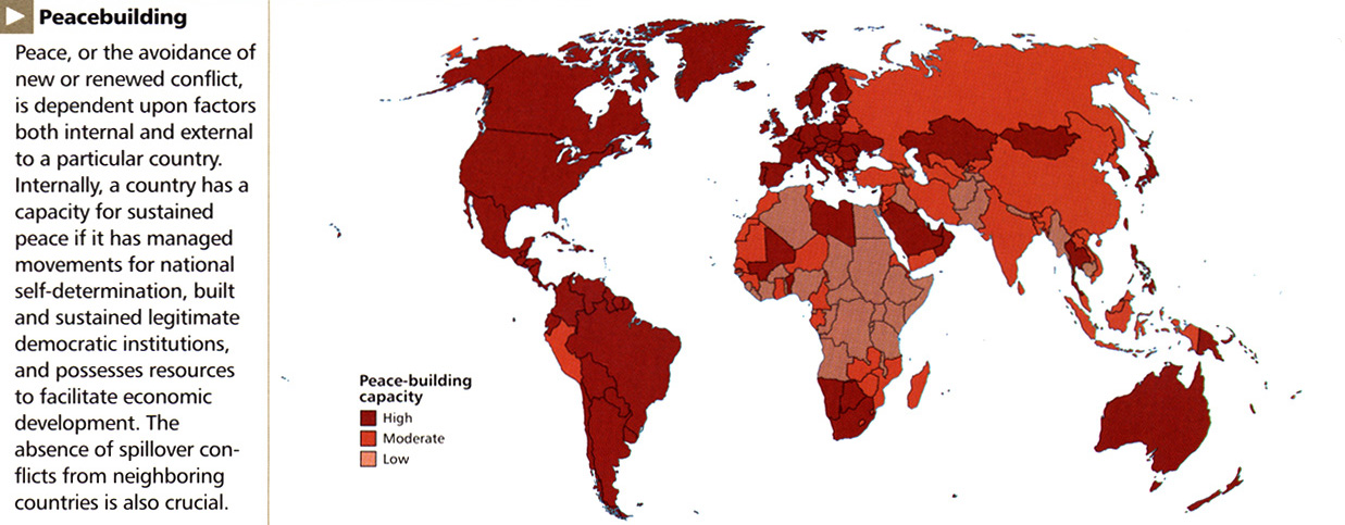
In this map countries are colored according to their peace-building capacity. Such capacity is asserted to be partially determined by internal factors such as the successful management of self-determination groups, and external factors such as the spillover of neighboring countries’ conflicts.
Legend indicates:
- Falu red: High
- Medium carmine: Moderate
- Old rose: Low
Source
National Geographic Atlas of the World, Eigth Edition. Published by the National Geographic Society. Prepared by National Geographic Maps for The Book Division, 2005, page 17.
Copyright
© 2005 National Geographic Society. All rights reserved.
Series
This map is one in a series:
- Image:Language Tapestry c. 2004.jpg
- Image:MG©Energy and Minerals, 2005.jpg
- Image:MG©Regional Trade Agreements, 2005.jpg
- Image:MG©Flow of Oil in the World, 2005.jpg
- Image:MG©World Grains, 2005.jpg
- Image:MG©World Debt, 2005.jpg
- Image:MG©World Forests, 2005.jpg
- Image:MG©Inter-Region Agricultural Trade, 2005.jpg
- Image:MG©Tourist Arrivals Worldwide, 2005.jpg
- Image:MG©The Internet Explosion, 2003.jpg
- Image:MG©Average daily per capita calorie consumption, 2005.jpg
- Image:MG©Connecting the Planet – Cables and Satellites, 2004.jpg
- Image:MG©Gross Domestic Product, 2005.jpg
- Image:MG©Labor Migration, 2005.jpg
- Image:MG©Chemical, Biological and Nuclear Weapons, 2005.jpg
- Image:MG©Political regimes, 2005.jpg
- Image:MG©Human Trafficking, 2005.jpg
- Image:MG©Peacebuilding, 2005.jpg
- Image:MG©International Migration, 2004.jpg
- Image:MG©Terrorism, 1995-2003.jpg