
Caption
Conflict in the Caucasus, 2000
Summary
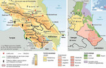
These two maps show both the military tensions in the Caucasus and the ethnic diversity found in the region.
The first map on the left shows armed conflicts (red stars on the map), oil pipelines (dashed lines), frontiers guarded by mixed Russian and national forces (in green), Russian military presence outside of the Russian Federation (a black soldier symbol), and Azerbaijani territories occupied by Armenian forces (red striped areas).
The second map shows various ethnicities in the area:
- Caucasian
- Vainakh
- Chechnyans
- Ingush
- People of Dagestan
- Avars
- Dargins
- Lezgins
- Laks
- Tabasarans
- Tsakhurs
- Rutuls
- Aguls
- Vainakh
- Altaic
- Azerbaijani
- Kumyks
- Nogais
Source
Cartographer: Philippe Rekacewicz
Primary Sources:
- Nicolas Beroutchachvili and Jean Radvanyi, Atlas géopolitique du Caucase, Inalco, Paris, 1996
- Central Intelligence Agency Maps and Publications.
Copyright
© Le Monde Diplomatique