
Caption
The Middle East in 1914
Summary
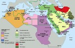
This map shows the the colonial divisions in the Middle East in 1914, including zones of influence, independent territories, and dates of occupation or treaty signature in the colonial territories. The map also shows the extent of the Ottoman Empire in the Middle East in 1800.
Translation
Territory Under Control:
- Britain
- France
- Italy
- Spain
- Date of Occupation or Treaty signature
- International Zone
- Independent Territory
- Ottoman Empire in 1914
- Limits of the Ottoman Empire around 1800
- International boundaries in 1914
Zone of Influence:
- Russia
- Britain.
Source
Cartographer: Philippe Rekacewicz
Copyright
© Le Monde Diplomatique