
Caption
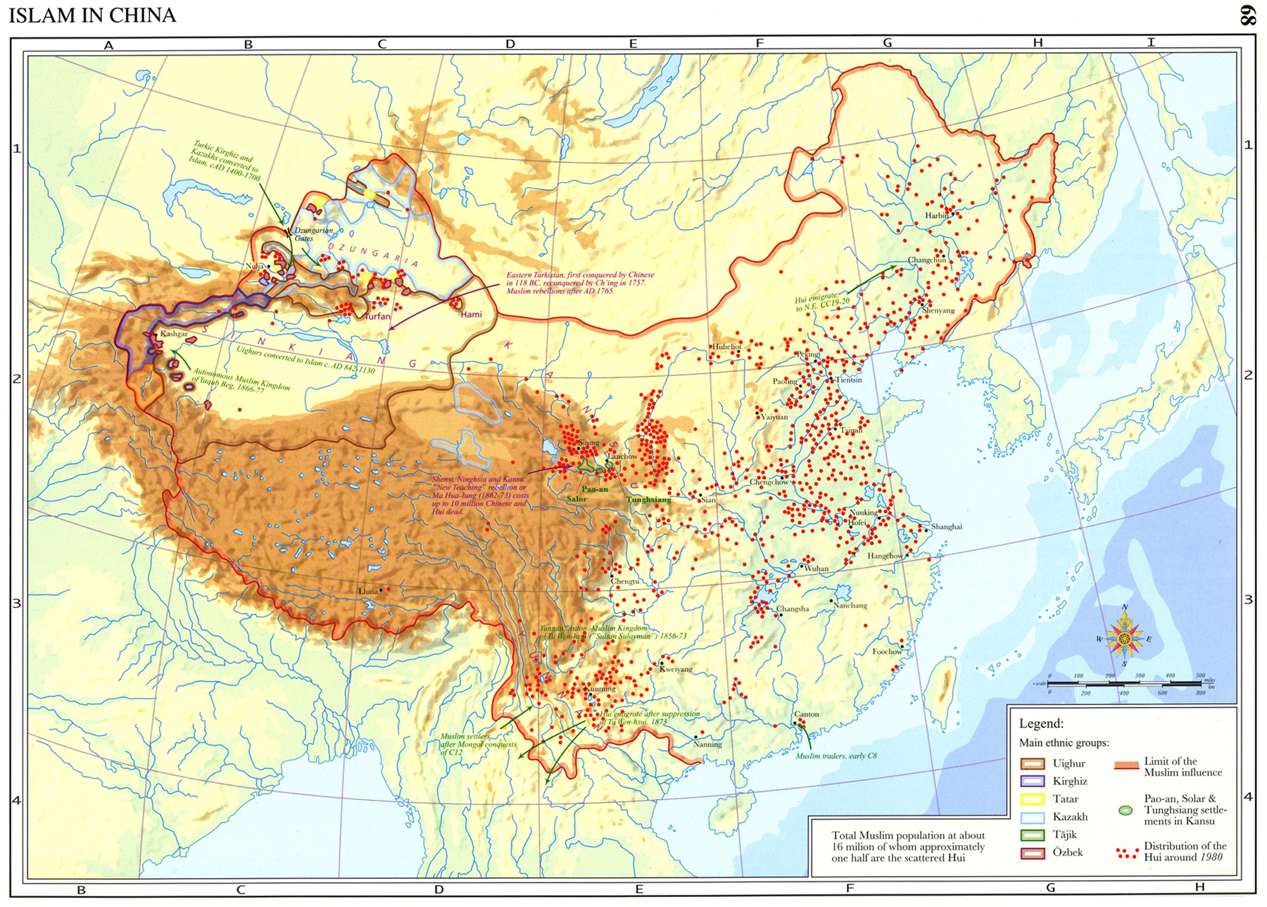
Islam in China, 9th-20th Centuries
Summary
This map shows the penetration of Islam in China. Overall, it took two main routes: from the south-east predominantly Arabs and Persians followed the maritime communications to Canton; from the north-west, predominantly Turks and Persians followed the Silk Road. This spread gave birth to the Hui (Chinese-speaking) Muslim community that is today scattered all over China.
Legend indicates:
- Limit of the Muslim influence
- Pao-an, solar and Tunghsiang settlements in Kansu
- Distribution of the Hui around 1980
Main ethnic groups (in different colors):
- Uighur [Uyghur]
- Kirghiz
- Tatar
- Kazakh
- Tajik
- Ozbek
“Total muslim population at about 16 million of whom approximately one half are scattered Hui.”
Source
An Historical Atlas of Islam – Atlas Historique de l’Islam, Second Edition. Edited by Hugh Kennedy, Tuta sub Aegide Pallas 1683,
Brill, Leiden-Boston-Koeln, 2002, page 68.
Cartography by Marc Bel, Peter van der Donck.
Copyright
© 2002 Koninklijke Brill NV, The Netherlands. All rights reserved.
Series
This map is one in a series:
- Image:MG©Environments and Mineral Resources of the Islamic World circa 390-1000.jpg
- Image:MG©Al-Andalus and Al-Maghrib- The Muslim Conquest, 44-732.jpg
- Image:MG©Islam in China, 9th-20th Centuries.jpg
- Image:MG©Linguistic Regions of the Islamic World circa 900-1500.jpg
- Image:MG©Ottoman Expansion 1362-1402 A.D. The First Conquest of Rumelia and Anatolia.jpg
- Image:MG©The Indian Ocean circa 390-1000.jpg
- Image:MG©The Muslim World circa 403-1100.jpg
- Image:MG©The Muslim World circa 700-1300.jpg
- Image:MG©The Muslim World circa 905-1500.jpg
- Image:MG©The Muslim World circa 1111-1700.jpg
- Image:MG©The Muslim World circa 1317-1900.jpg
- Image:MG©The Turks and Portuguese in the Indian Ocean 10th-16th Centuries.jpg
- Image:MG©The Western Mediterranean in the 3rd-9th C..jpg
- Image:MG©The World on the Eve of the Muslim Conquests circa 600 A.D..jpg
- Image:MG©The World According to Al-Idrisi 549-1154.jpg
- Image:MG©The World According to Al-Sharfi 986-1579.jpg