
Caption
Global Seismic Hazard Map
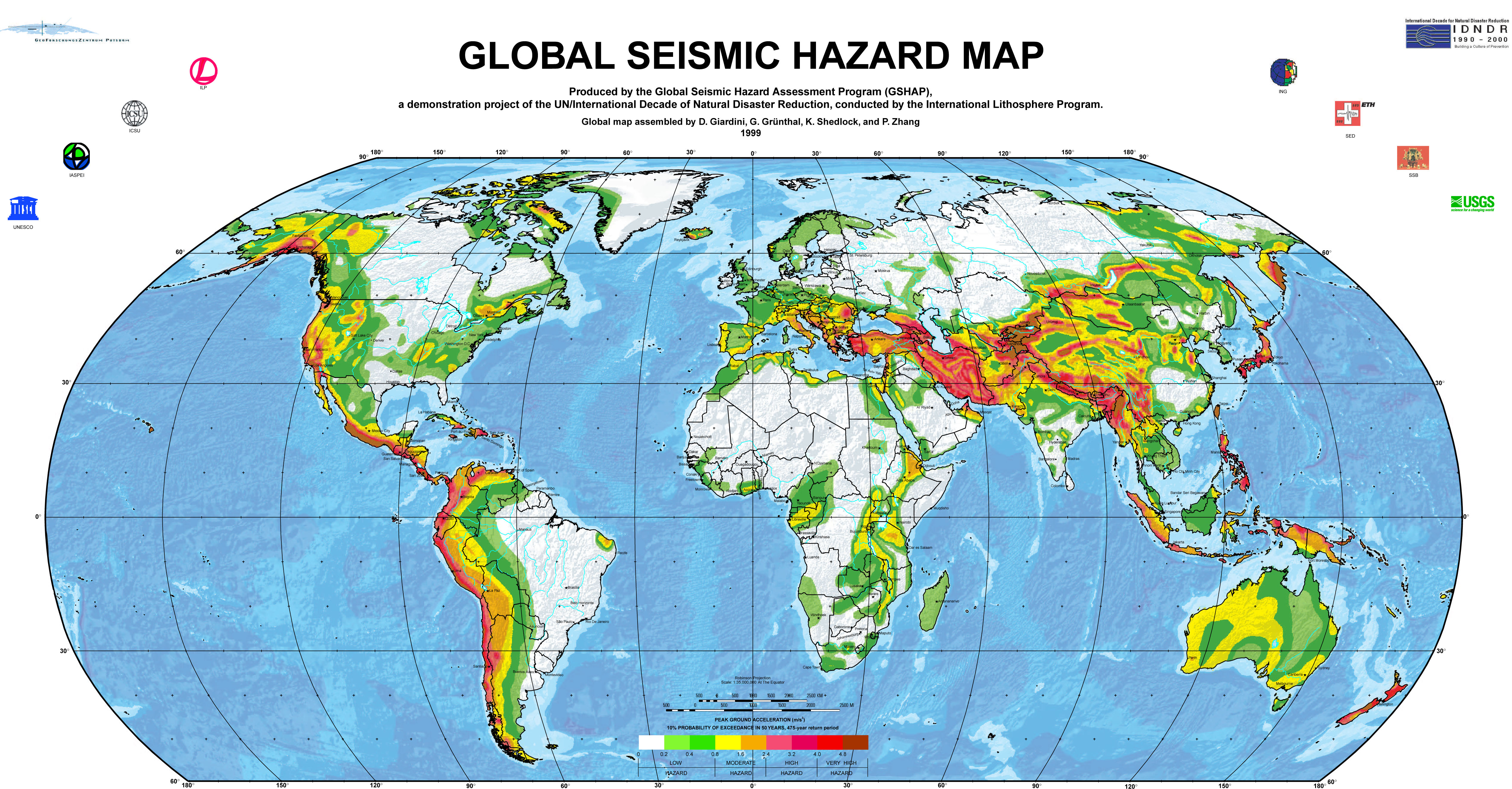
Produced by the Global Seismic Hazard Assessment Program (GSHAP), a demonstration project of the UN/International Decade of Natural Disaster Reduction, conducted by the International Lithosphere Program. Global map assembled by D. Giardini, G. Grünthal, K. Shedlock, and P. Zhang, 1999
Summary
This may be the first comprehensive global map of “seismic hazard” based on a consistent definition. Seismic hazard is defined in purely geophysical terms.
On the map, the colors define different hazard zones, in each of which the probability of there being a certain level of ground acceleration in the next 50 years is at least 10%.
GSHAP
The Global Seismic Hazard Assessment Program (GSHAP) was launched in 1992 by the International Lithosphere Program (ILP) with the support of the International Council of Scientific Unions (ICSU), and endorsed as a demonstration program in the framework of the United Nations International Decade for Natural Disaster Reduction (UN/IDNDR). The GSHAP project terminated in 1999.
Copyright status
“All GSHAP products and maps are available freely and are not covered by copyright, provided that the source is cited.”
Source
Global Seismic Assessment Program
File history
Click on a date/time to view the file as it appeared at that time.
| Date/Time | User | Dimensions | File size | Comment | |
|---|---|---|---|---|---|
| current | 19:10, 20 February 2008 | Peak (Talk | contribs) | 5,068×2,645 | 2.49 MB | ==Caption== Global Seismic Hazard Map Produced by the Global Seismic Hazard Assessment Program (GSHAP), a demonstration project of the UN/International Decade of Natural Disaster Reduction, conducted by the International Lithosphere Program. Global map a |
- Edit this file using an external application
See the setup instructions for more information.
Links
There are no pages that link to this file.
Metadata
This file contains additional information, probably added from the digital camera or scanner used to create or digitize it. If the file has been modified from its original state, some details may not fully reflect the modified file.
| Orientation | Normal |
|---|---|
| Horizontal resolution | 500 dpi |
| Vertical resolution | 500 dpi |
| Software used | Adobe Photoshop CS2 Windows |
| File change date and time | 14:39, 20 February 2008 |
| Color space | sRGB |
Categories: World Map | Knowledge | 20th Century | Safety |