Throughout the 19th century, the population growth in the Kensington District area was substantial. This presumably occurred due to the westward urban sprawl of the city, seeing inhabitants move out of the city centre and towards the outskirts. In the 1800s, the population was recorded at 8,556, yet by the 1890s the population had reached 163,151. This demonstrates a population rise of 1900% over a period of 90 years. Interestingly, Kensington is also significantly more populated than the surrounding metropolitan districts. This may suggest something about the social class of Kensington during this time – perhaps it was more affordable than the neighbouring Westminster and Chelsea vestries. At the beginning of the century Kensington was largely dominated by market gardens with large estates, meaning population density was low. However, beginning in the 1860s there was an infrastructural boom. In 1867 and 1868 construction in the Kensington district alone accounted for 10 percent of all building erections in London. Large properties were also subdivided during this time, increasing population density by creating room for a greater number of people to settle and minimising the number of families living on large estates.

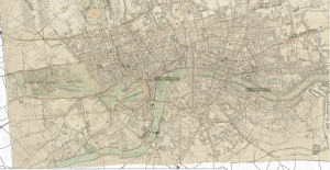
I also consulted some historic basemaps in order to get a better understanding of how the population density of the area changed over time. An 1818 map, Cary’s new and accurate plan of London and Westminster, the borough of Southwark and parts adjacent; viz. Kensington, Chelsea, Islington, Hackney, Walworth, Newington, &c….and plans of the New London & East and North India docks, reveals the Kensington district to have been relatively underdeveloped and rural during the 1810s.

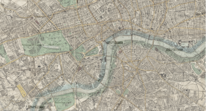
From this basemap, it appears that the area is dominated by large-sized parks, paddocks and grounds attached to expansive properties. However, the Stanford’s map of the British metropolis and its suburbs (Published by Edward Stanford) demonstrates that by 1884, Kensington was far more developed. You can even see a railway running through the area. I imagine this would have increased accessibility to the Kensington district and attracted more individuals looking to settle down among the outskirts of London. This may also explain why Kensington was more populated at the end of century than its neighbour Fulham – perhaps the railways did not stretch that far at that point.
