Visualizing Westminster Through Papworth’s Select Views of London

Papworth's Select Views of London
Papworth’s Select Views of London

I looked at John B. Papworth’s Select Views of London, published in 1816. There are only three plates related to my area. One is a view of St. John’s Church from the river. Another displays Westminster Abbey. The third shows St. Stephen’s Chapel and the Speaker’s House from Westminster Bridge. Thus, the guidebook highlights the religious and political focal points of the region, but leaves the rest unmarked. I found this lack of notation intriguing. It further underscores this juxtaposition I have previously described between the high and low ends of society. Moreover, Papworth’s choice to leave the rest of this area untouched suggests that he sees it as unremarkable. The full title of the book is Select Views of London; with Historical and Descriptive Sketches of Some of the Most Interesting of its Public Buildings. Thus, each plate (and the absence of a plate) is laden with intentional decisions. What determines an “interesting” building? Interesting to whom, and why? The large panopticon certainly drew my eye to the area as I viewed it from 2021, but that was not a public building Papworth wanted to bring attention to. Nor was the school and surrounding playground. This reminds me of another theme of Oliver Twist, which is the way those in power cast aside both children and prisoners as less than full human beings. Papworth sees the governmental and religious institutions in the area as valuable and notable for readers to know about and visualize, but he does not see the educational and penal institutions the same way. The continuity and contrast between how I see this area and how Papworth marketed it in 1816 is very interesting to me.  

Looking at the buildings that Papworth does depict reveals a few interesting notes. First, this guidebook initially caught my eye because it presents visual representations of the landmarks, rather than textual descriptions. The maps are limited in only showing an overhead, largely black and white view of the city. Papworth’s illustrations add color, dimension, and perspective to the our view of Westminster.

St. John's Church Westminster, from the river
St. John’s Church Westminster, from the river

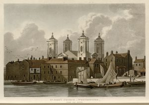
Rather than being a shaded polygon on the map, we see St. John’s Church as it would look from the Thames, and we see how its riverside location shaped the scene, with sailboats in the foreground of the image. Moreover, the sails appear to be in motion, being taken down from some of the boats, and the birds are in mid-flight. This gives dynamism to the image and puts us in the scene, bringing it to life.

Westminster Abbye & St. Margaret's
Westminster Abbey & St. Margaret’s

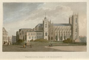
The plate displaying Westminster Abbey similarly adds to our understanding of life in London at this time, as we see people on and around the abbey grounds going about their days. We see children and families strolling along the street, and someone on horseback. In the background on the left we can make out people riding in a covered carriage. The people’s dress suggests that they are well-off which contrasts with the sense we got of the other area of Westminster around the penitentiary. 

St. Stephen's Chapel & Speaker's House, from Westminster Bridge
St. Stephen’s Chapel & Speaker’s House, from Westminster Bridge

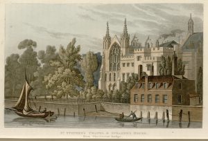
The view of St. Stephen’s Chapel and the Speaker’s House also presents a window into London life. We see people on boats on the river, adding to our sense of how the Thames is another space of interaction and motion in the city in addition to the streets and buildings. We also see the juxtaposition of the natural and the built environments again, with numerous trees in the foreground and smoke coming out of a building in the background. As the introduction to the site noted, London at this time is far ahead of other English cities in its industrialization and population growth. This image hints at the tension between the natural and the human that characterizes this era. Thus, Papworth’s guide is as interesting for what it depicts as for what it leaves untouched. 

Bridewell and Surroundings: Antiquities of London (1791-1800)

London constantly reinvents itself; John Thomas Smith’s Antiquities of London goes back in time to the first invention and builds the city back up from its relics and ruins. Within the confines of Bridewell and the surrounding area, this guidebook is able to highlight just how critical this place has consistently been for the city at large.

“Engravings of King Lud and his Sons [in the Bone-House of St. Dunstan’s Parish (Fleet Street)]”
The engraving depicting the oldest piece of history in this section of the map is about King Lud and his sons. In the caption to the engraving, it is mentioned that King Lud lived around the same time as Julius Caesar, and the phonetic degradation of Lud’s Town is what gave London its name. The king’s legacy is not just present in the name of the city, but Ludgate Hill and Street are also named after him. Importantly, Smith notes that the intended place for the statues was currently occupied by a statue of Elizabeth I, and since there is not enough space for three statues even if they replaced Queen Elizabeth’s statue with King Lud’s, Elizabeth’s statue would be staying where it was. There is a transition from the old to the new, from past monarchies to a more current one that follows the broader idea of reinvention. Nonetheless, there still remains a tradition of sorts within the reinvention. The monarchical family changes, but the area associated with the monarchy and the monarchy itself do not.

“London Wall, Ludgate Hill”

Smith’s engravings preserve previous versions of the city, but they also are a reminder that each reinvention of the city carries traces from past selves. At the end of the 18th century when he is making these engravings, the ruins of the London Wall—which were a part of the ancient city wall—are still there. Despite a devastating fire that burnt down nearly the whole city in 1666, Mr. Holden’s family vault in St. Bride’s Churchyard is still there.


“Entrance to Mr. Holden’s family vault in St. Bride’s Churchyard”
“Mrs. Salmon’s, Fleet Street No. 17”


There is a great attention to conveying the historical meaning of an engraved structure; therefore, when there is a certain engraving which misses this key trait, there are more questions raised by it than there are answered. One such engraving is the one of Mrs. Salmon’s Wax Work. The building appears to have been damaged given the fading, cracked paint on the top floor, and the fact that the building is not completely straight. Rather, it looks like certain components of the building that ought to be parallel are not because of some historical event or another. Smith’s guide, by documenting the remnants of the city’s past underlines the fragility and impermanence of the city at any one point in time as no moment in antiquity can be replicated entirely. This representation of the City of London, and Bridewell and the surrounding areas in particular shows the fleeting nature of a map of Bridewell.

The Humans of Bridewell and Surroundings

The area around Bridewell brings together people from all walks of life as one might expect from a place with a garden, two prisons, multiple churches, countless wharves, and a royal history. In addition, the small houses cramped together in the spaces left in between the various institutions suggests that the area was probably relatively densely populated. This makes sense as everyone might have a different reason for living there.

“A Whistling Shop. Tom & Jerry visiting Logic ‘on board the Fleet'” from Pierce Egan’s Life in London (1821)

Someone could be in Fleet Prison because they are in debt; another might be working at the prison. The drawing of the inside of a whistling shop from Egan’s Life in London shows the range of people who are living here. Within the same room, there is a man in tattered clothes warming himself by the fire, a woman with children, some card players, and almost everyone is drinking. The clothes of the people—especially the colours and cuts of their clothing, and the types of hats they are wearing—implies that most of these people are not from the same socioeconomic class; however, it is also clear that no one is from the upper-upper class, and there are very few from the lower-upper class, if indeed there are any. How much would things have changed in, say, fifteen years from the time this drawing was made in 1821?

“The Warden’s Room,” Pickwick Papers by Charles Dickens, image from chapter 41.

Charles Dickens could help us see that the answer is not that much. In his earliest novel, The Pickwick Papers, Mr. Pickwick ends up in Fleet Prison, and Dickens’s description wouldn’t appear strange to someone familiar with the prison from Horwood’s Plan.

Charlotte Brontë references another prison in this area during a game of charades in Jane Eyre: Bridewell. This prison starts off as a Tudor palace and is later converted into a hospital and prison during the reign of Edward VI. While the purpose of this building has changed over time, the various structures surrounding Bridewell are a reminder of its history through names like King Edward Street, St. Bride’s Church Yard, St. Bride’s Wharf, Crown Court, Tudor Street, Bride Lane, Bride Court…

“Poor Sweep, Blackfriars Bridge” from Mapping Modern London (1804)

Bridewell during the late 18th and early 19th century has significantly changed since its days as a royal palace. The Pass-Room from Ackermann’s Microcosm of London shows a Bridewell where women are sleeping on hay because there are not enough beds. It is probable that some of these women are single mothers since there are children in the middle of the drawing.

In addition to the prisons and people who live in the area because they are in some way connected to the prison system, another demographic to keep in mind is children working to survive. We see Blackfriars Bridge as a spot where crossing sweepers work in Modern London. This suggests there are also middle class people who are coming in and out of this part of the City of London since someone must be paying for this service provided by children. Bridewell and its surroundings is a point of entry into the district, and therefore it makes sense that the place be populous and host people from different socioeconomic backgrounds.

“Poor Sweep, Blackfriars Bridge” from Mapping Modern London (1804)

Bridewell and Surroundings: The Importance of Nature

The seam joining the Thames with the rest of the City of London is the wharves: just within the area surrounding Bridewell there are over fifteen of varying sizes. This abundance makes sense with the context given in Fores’s list that London harbours over ten thousand boats. As a result, however, the boundary between the natural and built environment is blurred even more than it already was; after all, where does the river end and the district begin if the boats are part of the city?

Blackfriars Bridge as depicted in Malton’s Picturesque Tour (1792-1801)

The natural environment—most notably the Thames—influences the built environment both in terms of the types of structures that need to exist to make this district the heart of the larger city, and in terms of the names of these structures. In addition to the wharves, a point of contact between this part of the City of London and the river is Blackfriars Bridge. Without the bridge and the wharves, not only would access to the area be far more limited, but this shift away from being a hub would fundamentally change the area’s identity since multiple structures have names referring to this symbiotic relationship between the natural and the built. The two most prominent streets that connect other smaller streets together are aptly named Fleet Street and New Bridge Street. The prison located right next to the intersection of these streets is also called Fleet Prison. There are numerous other smaller streets that highlight this Thames-based identity such as Little Bridge Street and Water Street.

Another important meeting point between the natural and the built environments is the Temple Gardens. The natural body of water directly next to the garden plays into the style of English gardens that contrasted from the jardin à la française. As can be seen in the image of Temple Gardens from 1809, the artificially created nature is still meant to look realistic to an extent. This is a heightened form of nature, but is, nonetheless, reminiscent of undisturbed nature. There is a deliberate attempt to work with nature—unlike the symmetrical and perfectly trimmed topiary common in French gardens—that makes this garden stand out as quintessentially English.

Temple Gardens, 1809
The gardens of Versailles; an example of a French garden for reference


Bridge Street, Blackfriars from Papworth’s Select Views (1816)

When we look at changes between Horwood’s Plan and Faden’s 1819 revision, we see there is a new and much smaller garden that is built right next to Bridewell. In addition to the garden, Bridewell also has a new chapel in its premises. Another change is the obelisk located in the intersection between Fleet Street and New Bridge Street. The obelisk must have been there since 1816 at the latest given the image of Bridge Street from Papworth’s Select Views includes the obelisk. The most substantial change in the area that alludes to technological developments of the time is the replacement of the New River Office and Yard with the Gas Light Company. The existence of the company suggests that using gas light must have been popular enough to sustain a business as early as 1819.

Bridewell Hospital and surrounding area in Horwood’s Plan (1792-9)
Bridewell Hospital and surrounding area in Faden’s 1819 revision. Orange highlights refer to places that have changed since Horwood’s original map. Green highlights refer to places mentioned in the current and following posts that have not changed between the two editions of the map.


Mapping Modern London: The Social Aesthetics of Westminster

The Modern London (1804) Guidebook to Landmarks embodies the civic duties and social atmosphere popular in the City of Westminster wherein the social motivations and priorities surround the promotion of London’s burgeoning culture and the traditions of the professional and those adjacent to the Crown. 

The Society of Arts encapsulates the public spirit of the age through its encouragement of the rapid progress and the prospering condition that contribute to London as a burgeoning Metropolis. Founded by William Shipley and other private gentlemen in 1754, this institution commends and awards Premiums and prizes to individuals who have achieved success in areas encouraging the arts, manufactures, and commerce. Oblong and elegantly proportioned, the meeting room is arranged in an oval form, where portraits of noble lords and The President, his Grace the Duke of Norfolk, are hung with esteem. The Society’s prominence is acknowledged in the seating of the committee, wherein the distinguished attendees include the Secretary, the Assistant Secretary, the Vice-Presidents and Chairmen of Committees, ladies of rank, and duchesses, foreign ministers, and other dignitaries of distinction. 

A sketch of the Society of Arts, located in the Modern London (1904) Guidebook to Landmarks, situated between Covent Garden and Westminster, in a moment of awarding its annual prizes for the encouragement of arts, manufactures, and commerce.

In continuing with the Society’s reputation for the encouragement of excellence in the arts and commerce, the walls are decorated with a series of paintings, among the finest productions of the age, to represent man’s progress in civilization. Remarked by the refinement of its taste, these paintings include the Society’s President as part of the Olympic Games, a picture of prominent men in robes distributing the rewards of the Society, and the Triumph of Navigation, where Father Thames, designed with charming extravagance, sits in a car being drawn by river nymphs. The exquisite atmosphere projected by the Society of the Arts infers that the priorities of this guidebook correlate with the notion of leisure, in that, this landmark, considered one of the finest spectacles in Europe, is tailored to describe those who have the luxury and time to promote artistic expression and culture.

A sketch of the three principal offices connected with the government of the country: The Treasury (right), The War-office (center), and The Admiralty (left) from the Modern London (1904) Guidebook to Landmarks. The Parade of the Foot Guards present themselves in the foreground.

The guidebook details the Horse Guards or War-Office, wherein the landmark indicative of these public buildings is one of the finest about the Metropolis. In one view, this landmark beholds three principal offices connected with the government: The Treasury, The War-office, and The Admiralty. The War-Office, located in the center of the three, comprises the station where part of his Majesty’s troops usually perform duty. The Treasury, located to the right of the War-Office and enclosed with a wall, contains the gardens of the house, while the building to its left is The Admiralty, home to the apartments and offices of lords. The significance of government buildings prioritizes a professional, educated attitude surrounding the inhabitants of Westminster.

The Parade of the Foot Guards, another landmark, celebrates tradition and honors achievements, as inferred from the decor of the Turkish piece of ordinance. Brought by British troops from Alexandria, the ordinance is mounted on a carriage of English workmanship and ornamented with very elaborate devices to display London’s successes and global reach.


Populating the Social Elite: The Proliferation of Gardens and Entertainment in the Liberty of Westminster

Neighboring the Queen’s Palace, the demographic of Westminster’s population comes across as less dense than the surrounding area of London as delineated by the red line on Horwood’s Plan (1792-1799). Comparable to the city and its additional boroughs, Westminster gives the impression it is heavily populated. However, the city’s residence next to Saint James’s Park, Green Park, and the Queen’s Gardens, as well as the city’s location, a mere one street from the River Thames, give the illusion of more open space. While London, as a whole, persists upon its placement about the Thames, the institutions of which make up the City of Westminster strongly point to its higher-class residency, who, of which, make up the court, the nobility, and other people of distinction, with a certain composition of tradesmen and artists. Dividing the City of Westminster into subcategories based on points of interest: establishments of leisure and entertainment, institutions of reverence, and buildings that pertain to the adjacent parts of the royal services, we can begin to comprehend the livelihood and professional nature of this upper-crust population. 

A screenshot of Fores’s Guide (C. 1789) indicating the close proximity of The Little Theatre (above) and the Italian Opera (below) on Haymarket Street.

The presence of two theatres on Haymarket Street indicates that those who live in this area can afford leisure activities or comprise the actors that perform at these companies. The seasonal nature of this amusing pastime, The Little Theatre’s summertime availability, and the Italian Opera’s wintertime entertainment emphasizes that this leisure activity is offered only to those who can afford to enjoy the social and cultural amenities of year-round entertainment.

In addition to Saint Martin’s Church, a notable institution of reverence and considered one of the finest churches in London, The Banqueting House of Whitehall demands the same category of distinction. Host to daily divine service, The Banqueting House of Whitehall beholds a statue of James II upon a pedestal, esteemed to be one of the finest of its kind in England, and serves as an area of notoriety, praise, and respect.

The Admiralty is a large office and apartment building occupied by the lords that possess a large hall and seven spacious houses appointed only to the lords and commissioners of The Admiralty. The elegant wall designated in front of the court gives The Admiralty its air of exclusivity and prominence.

With Westminster’s proximity to the Queen’s Palace, The Horse Guards and The Kings Mews are buildings that concern adjoining parts to royal services. The King Mews, or the falconry of the King, was converted into a stable for horses and coach of state by Henry VIII. Constantly on duty as sentinels, the armed troops that constitute The Horse Guards stand watch on horseback. However, this building serves a dual purpose, functioning as a control point to a vaulted passage that leads into Saint James’s Park.

The prominence that these points of interest indicate that the inhabitants of Westminster are educated and affluent, and those employed by these institutions are likely in the service of the Queen.


Leisure and the Social Elite: Color and the Environment in the City of Westminster

The environment surrounding the City of Westminster and its adjacent parts favors the occupation of the social elite as well as the polite and commercial artists. Where the main feature of the natural environment in the City of London gravitates around the River Thames, running centrally through the city, the built environment surrounding the Liberty of Westminster differs from the domains encircling the Tower of London and the Docklands that run along the water. As topographically delineated by the red line separating London proper from the surrounding areas in Horwood’s Plan (1792-1799), the City of London is predominantly impacted by buildings and industry, with a notable lack of surrounding natural environment that exists apart from the River Thames. This contrast is especially distinct when juxtaposed with the surrounding environment outside of this topographical border; wherein the geographics of Westminster possess more freedom for leisure with its numerous fields and gardens than the rest of London’s inherently compact, urban cityscape. Rather than the occupation of industrial warehouses and wharves, as is the case closer to the city surrounding the Tower, the buildings located alongside the River Thames in Westminster cater towards a more dignified and upper crust crowd that persists in this location so close to the Queen’s Palace and Parliament Street. This stretch along the River Thames consists of the Privy Gardens, Westminster Hall, and Northumberland Gardens, with a few wharves recognized by the names Scotland Yard and White Hall Timber Yard.

The area surrounding the intersection of Charing Cross and Cockspur Street is relatively similar in both Horwood’s Plan (1792-1799) and Faden’s 1819 revised mapping of London. The built environment remains the same, favoring the habits of the upper class and persons of notable distinction, such as the royal family and members of Parliament, wherein occupancies of leisure, such as opera houses, gardens, and squares, persist more frequently compared to the more industrialized and mercantile subsection of London that makes up the habitations of tradesmen and the merchant class. While Haymarket Street and its opera houses prevail into Faden’s 1819 revision, Regent Street, running perpendicular to Charles Street outside of Saint James’s Square, is a new addition that had required the tearing down of residences that line Haymarket Street in Horwood’s Plan. The incorporation of color, however, in Faden’s 1819 revision, gives light to the overwhelming presence of gardens. While the existence of gardens persists more frequently in the Liberty of Westminster, as indicated by Horwood’s Plan of London (1792-1799), the color reveals how expansive and frequent these gardens appear to exist. The existence of such gardens alongside the River Thames, in particular, delineated in this stretch that borders Westminster and Covent Garden noted in the 1819 revision, is much more frequent than the showing of gardens located near the Thames in the Docklands. Faden’s attention to color characterizes the Liberty of Westminster by its inhabitants’ accessibility to leisure activities, systematizing London’s burgeoning Metropolis through this geographical assumption by class to suggest that the occupants in this subsection of London concern the social elite.