A Tuesday Stroll Down Tottenham Court Road

An aerial view of Tottenham Court Road, from “London: illustrated by eighteen bird’s-eye views of the principal streets.”

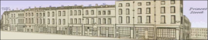
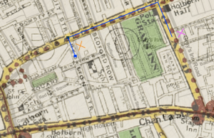
You have to keep your wits about you, strolling up Tottenham Court Road on a Tuesday. The horses and carriages that pummel the cobblestones of this long arterial street are the most deafening of all the noises you hear; everyone seems to be in a rush to catch their train from Euston back up to Birmingham, wanting to make the five-hour trip in the hazy sunlight of this warm May morning, and arrive home before it gets too dark. The street peddlers give the carts a run for their money, though, flogging their vegetables outside Mortimer Market in high-pitched screeches, before running to evade the bobbies charged with disbanding such unruly conduct.

Strolling up from Oxford Street, the first thing you smell is the whiff of porter from Meux’s Brewery (the smell is delicious, but you’re hoping the walls of the brewery don’t explode like they did in 1814 with the London Beer Flood). The intellectual types pour out from Great Russell Street, seeking their midday repast after a morning among the books at the British Library and the wondrous sculptures of the Parthenon at the British Museum. They dive into Lansdall’s, the baker’s, (and no doubt will try their luck at the brewery afterwards), but you carry on up past Danks’s carpet warehouse and stroll northwards. A gorgeous piece of china catches your eye in Moore and Co, so you end up spending a good twenty minutes perusing the furniture from across the world before negotiating a good deal on the teacup you saw in the window as you passed by.

A bustling portion at the top of Tottenham Court Road, illustrated by Tallis (1838-40).

By this point you’re quite tired, so you jump into Leopard Coffee House on the corner of Francis Street for a quick drink but end up whiling a couple of hours away in a good game of whist. There are all kinds of curiosities along Tottenham Court Road – baskets, boots, silk, pans, iron kettles and more are for sale, as you continue on your walk up the street. It’s not quite as flashy as Regent Street, but it has all manner of products for the discerning consumer. Indeed, every now and then, you’ll hear a baker or a confectioner offering a sample of their wares. Up near the top end of the street, you catch a glimpse of University College’s vast dome and its domineering portico, and can’t help but be inspired by these architectural feats on offer in this temple for learning.

Journeying to Red Lion Street: An Errand-Boy’s Holborn Adventure

“More laudanum and some opium, quick!” were the last words you heard before you were hustled outside, handed your cap and tossed some coins. You barely register the click of the door closing behind you as you survey the bustling Gray’s Inn Road and hurry your way up the street toward Theobalds Road. Although you were initially glad to be rid of the stench and filth of the Royal Free Hospital’s dysentery quarters, your nose is soon overwhelmed by the foul smell of the horse dung and urine you slosh through on the streets. As you come across a gaggle of boys your age trying in vain to dodge the oncoming carriages and scoop up horse droppings, you feel a new wave of appreciation for your position with Dr. Marsden and pick up your pace.

A left on Theobalds Road and you suddenly have an unobstructed view of Gray’s Inn Fields, and your favorite gardens and walkways in the area. Briefly tempted to dally with the strolling masses enjoying the day, you trudge on and soon turn onto Red Lion Street. You immediately get caught up in the huddled mass of people outside your destination: L.W ROE, Chemist. Shouting, “Urgent order, Royal Free Hospital!” you shove your way through children in line for the new shipment of Ayer’s Cherry Pectoral as well as a few coughing old women, desperate for chlorodyne. Once you get to the counter, you are immediately serviced by the chemist’s apprentice, long-familiar with your face as the Hospital errand boy. He wraps your laudanum and opium (the cheap, varnish-coated kind) in brown parchment and you head back outside.

A view from the street of the chemist and the tailor (both far left) and the surrounding buildings on Red Lion Street.

Finished with your errand sooner than expected, you contemplate whether you have time to check out Furnival’s Inn on High Holborn (you heard Charles Dickens might be back in residence) but quickly think better of it. Instead, you opt to venture further down Red Lion Street. A few buildings down you marvel at the shining looking glasses in a shop window. Pressing your nose to the window and peering inside, you can see a beautiful young woman admiring a delicate handheld mirror and chatting with the shop owner while her maid waits patiently. You watch her until the shop owner spies you and lets out an angry exclamation as he storms towards the door. Time to go, you think, and walk briskly back the way you came.

A map of the route (in blue) taken by the errand boy from the Royal Free Hospital to Red Lion Street (drawings done on Edward Stanford’s map of central London). The pink “X” represents the location of the Royal Free Hospital while the orange “X” represents the block of stores (the chemist, the looking glass store and the tailor) on Red Lion Street.

Before you turn back onto Theobalds Road, you pause at the tailor’s storefront. Looking down at your coat, torn at the cuffs and stained with the soot that permeates the air, you long for one of the stylish coats with glossy buttons featured prominently in the window. A crack of a driver’s whip brings you out of your daydream — you stood mesmerized in front of the tailor’s for far too long! Tucking your package of medicine into your chest, you race back to the Hospital, praying you return fast enough to not get your ears boxed. 

Leisure and the Social Elite: Color and the Environment in the City of Westminster

The environment surrounding the City of Westminster and its adjacent parts favors the occupation of the social elite as well as the polite and commercial artists. Where the main feature of the natural environment in the City of London gravitates around the River Thames, running centrally through the city, the built environment surrounding the Liberty of Westminster differs from the domains encircling the Tower of London and the Docklands that run along the water. As topographically delineated by the red line separating London proper from the surrounding areas in Horwood’s Plan (1792-1799), the City of London is predominantly impacted by buildings and industry, with a notable lack of surrounding natural environment that exists apart from the River Thames. This contrast is especially distinct when juxtaposed with the surrounding environment outside of this topographical border; wherein the geographics of Westminster possess more freedom for leisure with its numerous fields and gardens than the rest of London’s inherently compact, urban cityscape. Rather than the occupation of industrial warehouses and wharves, as is the case closer to the city surrounding the Tower, the buildings located alongside the River Thames in Westminster cater towards a more dignified and upper crust crowd that persists in this location so close to the Queen’s Palace and Parliament Street. This stretch along the River Thames consists of the Privy Gardens, Westminster Hall, and Northumberland Gardens, with a few wharves recognized by the names Scotland Yard and White Hall Timber Yard.

The area surrounding the intersection of Charing Cross and Cockspur Street is relatively similar in both Horwood’s Plan (1792-1799) and Faden’s 1819 revised mapping of London. The built environment remains the same, favoring the habits of the upper class and persons of notable distinction, such as the royal family and members of Parliament, wherein occupancies of leisure, such as opera houses, gardens, and squares, persist more frequently compared to the more industrialized and mercantile subsection of London that makes up the habitations of tradesmen and the merchant class. While Haymarket Street and its opera houses prevail into Faden’s 1819 revision, Regent Street, running perpendicular to Charles Street outside of Saint James’s Square, is a new addition that had required the tearing down of residences that line Haymarket Street in Horwood’s Plan. The incorporation of color, however, in Faden’s 1819 revision, gives light to the overwhelming presence of gardens. While the existence of gardens persists more frequently in the Liberty of Westminster, as indicated by Horwood’s Plan of London (1792-1799), the color reveals how expansive and frequent these gardens appear to exist. The existence of such gardens alongside the River Thames, in particular, delineated in this stretch that borders Westminster and Covent Garden noted in the 1819 revision, is much more frequent than the showing of gardens located near the Thames in the Docklands. Faden’s attention to color characterizes the Liberty of Westminster by its inhabitants’ accessibility to leisure activities, systematizing London’s burgeoning Metropolis through this geographical assumption by class to suggest that the occupants in this subsection of London concern the social elite.