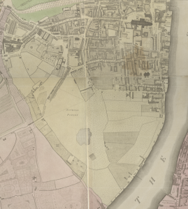
I chose to explore an area on the outskirts of Westminster. I focused on the section along the bank of the Thames stretching from Westminster Abbey to the Tothill Fields. This slice of London presented an interesting juxtaposition of highly-developed and undeveloped areas. In Horwood’s plan, the amount of open green space is striking. There are no roads in the area surrounding the Tothill Fields, and the fields themselves are left as open grassy areas (they would later become the site of a playground). This section is completely isolated, with no bridge across the river and no roads to the west. The only institution in this part of the map is the Grey Coat School. Looking here brings you to the border of the more developed part of my area of focus. The school borders the last street before the fields, Horse Ferry Road. From here, I looked at the area circumscribed by Strutton Ground Road Way on the left, with Westminster Abbey and the Thames serving as the other borders. In this section, only a few institutions are labeled. Two are churches: St. John’s Church and Westminster Abbey. The other three are seats of government: Westminster Hall, the House of Lords, and the House of Commons. The House of Lords and House of Commons are not labeled on Harwood’s map, but the 1789 Fores’s Guide identifies them. Aside from these, and Pearce’s Brewery along the riverbank, nothing is labeled. Numerous homes line the streets, thinning out as you move away from Westminster Abbey towards the Tothill Fields.
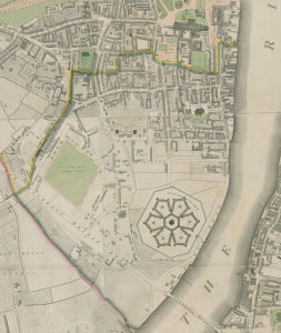
These characteristics of the area help explain the main change between Horwood’s Plan and Faden’s 1819 revision: the construction of a penitentiary. In the once-isolated area by the Tothill Fields, a penitentiary has been built. I’ll explore the human impact of the prison’s panopticon design in the next post, but here I’ll focus on the relationship between the natural environment and the location of the prison. This area is slightly more developed than in Horwood’s Plan. The Tothill Fields are gone; there are now a few streets with houses and a butter factory. Near Grey Coat School, there is now a playground for students. Moreover, Vauxhall Bridge now connects this area to the land across the Thames, and the large Vauxhall Bridge Road makes this location more accessible. Still, the area immediately surrounding the prison is largely undeveloped, and the natural environment here makes it a fitting location for a penitentiary. The nearby river allows for easy transport of prisoners, but makes escape difficult. The open space around the prison likewise inhibits escape. Moreover, the large open space allows for the sprawling panopticon design of the penitentiary. In these two views of Westminster from Horwood and Faden, we can see how its natural environment with the Thames and open land shapes the development of this area of the city.
