Steve McQueen Timeline
Steve McQueen Image Gallery


An Overnight Success: A Brief Biography of Monica Ali
Monica Ali is an award-winning, best-selling writer. She is most renowned for her breakthrough novel Brick Lane, which brought attention to the Bangladeshi immigrant experience in London.

Ali is the daughter of English and Bangladeshi parents and was born in Dhaka, Bangladesh in 1967. In 1971, aged three, Ali’s family moved to Bolton, England, in order to escape the civil war that erupted in Pakistan. After attending the Bolton School, she studied Politics, Philosophy and Economics at Oxford University and graduated from Wadham College. She then entered the field of publishing, working in the marketing department of a small publishing house before moving into sales and marketing management positions at the publishing house Verso. Ali married a consultant, Simon Torrance, and gave birth to her first child in 1999. She subsequently begun to experiment with writing fiction, but soon found that short stories did not suit her. After giving birth to her second child in 2001, Ali’s father died. His death prompted her to begin work on her first novel, “Brick Lane”. It was published in 2003 to critical acclaim and was adapted into a film released in 2007. Ali now lives in London with her family.
Historical and Geographical Context of Children of the Ghetto
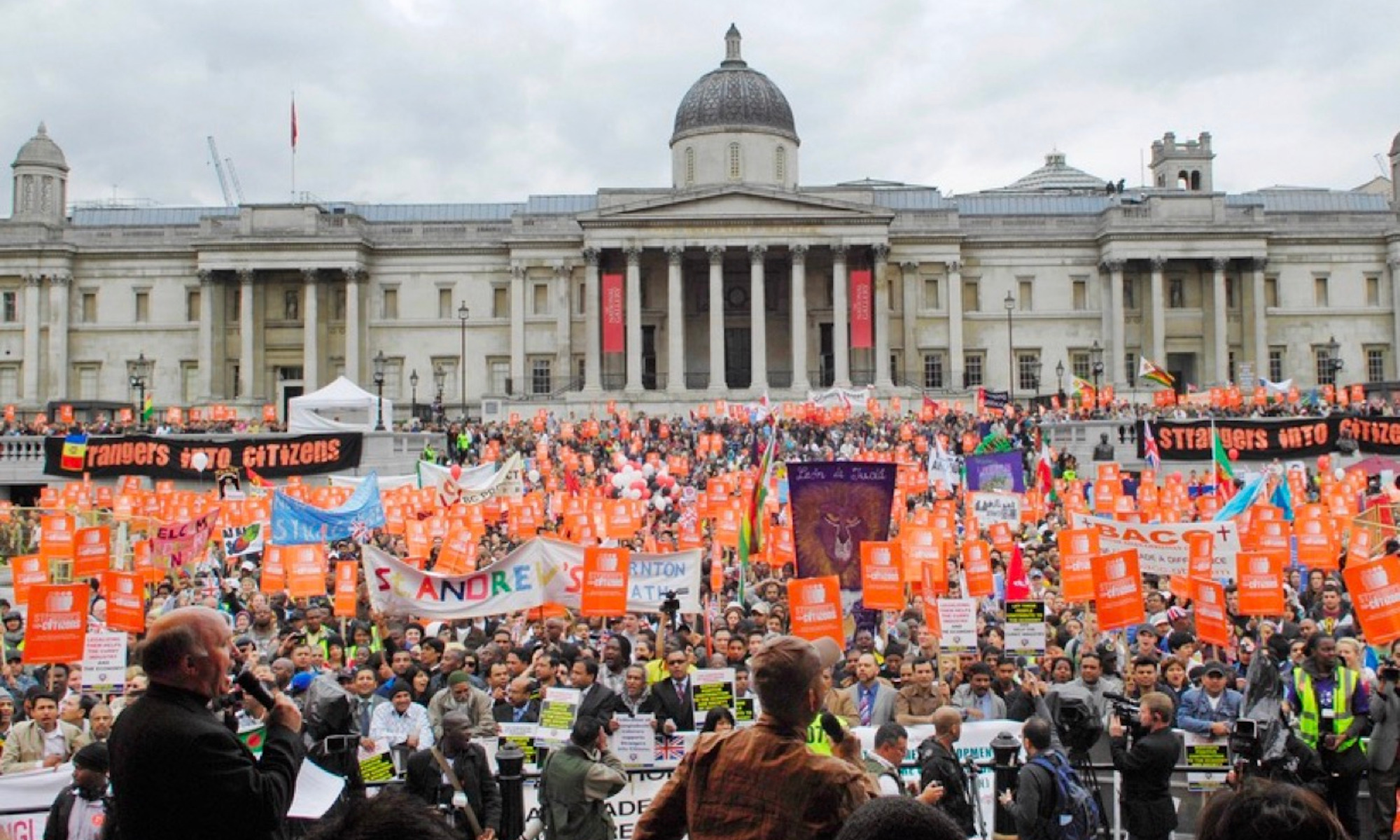
The historical moment of the 19thcentury as well as the geographical of the east end is clearly presented through Zangwill’s soup kitchen scene. The passage comes from the first chapter of Children of the Ghetto, following a prologue which described life in the ghetto and the strong personal and religious community that was found there in the past. The contrast between the community seen in the prologue and in the first chapter is incredibly strong. In the past, rich individuals (the Takeefin) “gave charity unscrupulously” to the poorer members of their community but in the first chapter we see “the President addressed the meeting at considerable length, striving to impress upon the clergymen and other philanthropists present that charity was a virtue.” While not stated directly, in the passage above Zangwill appears to be mocking the new generation of Takeefin who seemingly need the poor to validate their charitable acts in order to perform it which undercuts the basis of their charity I believe that the rich’s attitude towards charity was less condescending and came more from a genuine desire to help others in past generations as the community was congregated in closer proximity to one another and the rich felt a connection to the people that they were serving. In the passage I discussed above, the rich have transformed from a helpful neighbor to a semi-divine because the community is no longer as closely in touch spiritually or geographically. In the time period of the book, the rich lived “far away” in neighborhoods like Belgravia while the larger poor community was left in Spitalfields as opposed to when nearly all of the Jewish population of London was living in Whitechapel. The passage illustrates the effects that decentralizing the Jewish community has taken on the feeling of community and the spiritual reasons for upholding Jewish values.

Whitechapel: Charity and Industry at Odds
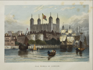
Although one of the more densely populated areas in London, Whitechapel began the nineteenth century with few social institutions. At this time, its most notable landmarks were the Royal Mint and the notorious Tower of London, which was, by now, more of a landmark than a functioning prison. London Hospital, charged with healing the poor, the Magdalen Hospital For Penitent Prostitutes, and two organizations that served food (Spitalfields Soup-Ladling Society and the Eastern Dispensary) were dispersed throughout the district. The institutions and their images reveal a stark division. This southernmost area of the district home to industry and government building resembles a different world the the London Hospital, located in the northernmost area of the district. Where the Tower of London is depicted as an almost fairytale romanticized image, the London Hospital lacks ornament or festivity. One representative of the power of the state and its city, the other an expression of its weakness and vulnerability.
.

Between 1801 and 1830, development seemed to be more acutely focused on industry. The only two such institutions that would emerge during the period were both for sailors (the Asylum For Destitute Sailors and the Sailors Home. Furthermore, a grove of lower income housing or as the Victorian London Map describes “slums” occupy the area just East of the Government building. Only 26 years later would construction begin on the three enclosed docks bordering the Thames. Thousands would be displaced, forced out without refuge or compensation. The image of the smaller of the three docks remain, St. Katharine Dock. Only a lone manless boat stands in the place of a once bustling community.

In 1859, the Whitechapel workhouse would be built on the ruins of the Spitefield Parish Workhouse. The establishment of a workhouse would suggest a large influx of a lower income population as well as a greater immigrant presence. This conjecture aligns with population data during the time. Between 1840 and 1860 the population increased by over 15,000 persons. However, just when the workhouse was established the Magdalen Hospital For Penitent Prostitutes was shut down. The reason for this anomaly may be due to the Contagious Disease Act of 1864, which called for the investigation and imprisonment of any women confirmed or even suspected of prostitution. This suggests charitable work for this particular group may have become less desirable or harder to fund leading up to the passing of the act. The King Ragged School And Girls Refuge would sprout up in its place.
In fact, the next two decades, between 1861 and 1880, would see an increase in the number of refuges for both young men and women as well as almshouses. While the population actually decreased during this period by 3,186 persons, the founding of these institutions may have been in reaction to or because of an increased awareness of the growth during the decades prior. In the following two decades, the number of these accommodations would continue to grow. A new kind of institution emerged during this period that was interested in offering free education and enrichment, not for the purpose of schooling young children in a particular skill, but cultural institutions. Whitechapel Art Gallery and Whitechapel Library both served this purpose. While Whitechapel’s identity as a place of industry and government was solidified, so did its awareness of its new and less prosperous population grow.
Visualizing Westminster Through Papworth’s Select Views of London
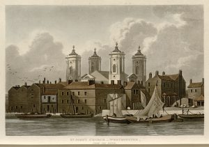
I looked at John B. Papworth’s Select Views of London, published in 1816. There are only three plates related to my area. One is a view of St. John’s Church from the river. Another displays Westminster Abbey. The third shows St. Stephen’s Chapel and the Speaker’s House from Westminster Bridge. Thus, the guidebook highlights the religious and political focal points of the region, but leaves the rest unmarked. I found this lack of notation intriguing. It further underscores this juxtaposition I have previously described between the high and low ends of society. Moreover, Papworth’s choice to leave the rest of this area untouched suggests that he sees it as unremarkable. The full title of the book is Select Views of London; with Historical and Descriptive Sketches of Some of the Most Interesting of its Public Buildings. Thus, each plate (and the absence of a plate) is laden with intentional decisions. What determines an “interesting” building? Interesting to whom, and why? The large panopticon certainly drew my eye to the area as I viewed it from 2021, but that was not a public building Papworth wanted to bring attention to. Nor was the school and surrounding playground. This reminds me of another theme of Oliver Twist, which is the way those in power cast aside both children and prisoners as less than full human beings. Papworth sees the governmental and religious institutions in the area as valuable and notable for readers to know about and visualize, but he does not see the educational and penal institutions the same way. The continuity and contrast between how I see this area and how Papworth marketed it in 1816 is very interesting to me.
Looking at the buildings that Papworth does depict reveals a few interesting notes. First, this guidebook initially caught my eye because it presents visual representations of the landmarks, rather than textual descriptions. The maps are limited in only showing an overhead, largely black and white view of the city. Papworth’s illustrations add color, dimension, and perspective to the our view of Westminster.
Rather than being a shaded polygon on the map, we see St. John’s Church as it would look from the Thames, and we see how its riverside location shaped the scene, with sailboats in the foreground of the image. Moreover, the sails appear to be in motion, being taken down from some of the boats, and the birds are in mid-flight. This gives dynamism to the image and puts us in the scene, bringing it to life.
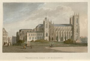
The plate displaying Westminster Abbey similarly adds to our understanding of life in London at this time, as we see people on and around the abbey grounds going about their days. We see children and families strolling along the street, and someone on horseback. In the background on the left we can make out people riding in a covered carriage. The people’s dress suggests that they are well-off which contrasts with the sense we got of the other area of Westminster around the penitentiary.
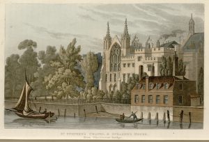
The view of St. Stephen’s Chapel and the Speaker’s House also presents a window into London life. We see people on boats on the river, adding to our sense of how the Thames is another space of interaction and motion in the city in addition to the streets and buildings. We also see the juxtaposition of the natural and the built environments again, with numerous trees in the foreground and smoke coming out of a building in the background. As the introduction to the site noted, London at this time is far ahead of other English cities in its industrialization and population growth. This image hints at the tension between the natural and the human that characterizes this era. Thus, Papworth’s guide is as interesting for what it depicts as for what it leaves untouched.
The Panopticon and the Human Side of Life in Westminster

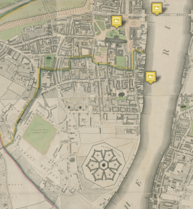
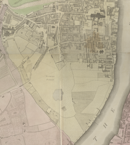
To understand the human side of life in London at this time, I focused on the penitentiary in the 1819 revision of Horwood’s map. One of the key aspects of nineteenth century London that we have discussed is the criminalization of poverty, including for children like the characters in Oliver Twist. The penitentiary highlights this impulse for punishment. Moreover, the design of the penitentiary points to how entrenched this approach to governance is. The prison is constructed as a panopticon. The intention of this design is to emphasize constant surveillance. Every cell is within view of a central security tower. While the guard cannot always observe every prisoner, the fact that the prisoner does not know if he is being watched at any given time forces him to always be on guard. This architecture, and the social theory that underlies it, shows how the built environment of London at this time evinces the philosophies and ideologies that predominated. Another key feature of the prison that struck me is the emphasis on isolation. There is one small entrance to the complex; the rest is completely walled off. Within these outer walls, each section of the prison is also walled off from all the others. It looks like the only way to pass from one arm of the panopticon to another is via the central sector around the chapel. This further underlines how the purpose behind the prison is primarily to punish, not to rehabilitate, and to strip the prisoner of his humanity. In light of this, the presence of the chapel in the center of the prison is especially interesting. As previously mentioned, churches are among the few institutions in this area of the city. In our conversations about Oliver Twist, we discussed how religion and government were often intertwined in London at this time. In that light, it makes sense that there would be a chapel within a correctional institution, especially since crime was viewed as a personal, rather than societal, failing.


Zooming out from the penitentiary, we can understand some more of the human dimension of life in Westminster. The presence of the prison suggests that some of the people living in the area are its employees. Along with the butter factory in Faden’s map, whose employees also presumably live in the area, this appears to be a working class part of the city. Moreover, the school (and its expansion with the playground by 1819) suggests a significant number of families live in this part of the city. The proximity of the legislative and judiciary arms of government may suggest that government officials reside nearby as well. Thus, there is an intriguing juxtaposition between the upper and lower classes as you move from the area around Westminster Abbey and the governmental buildings towards the penitentiary. In this one segment of London, we can see a wide swath of what life was like, and the social theories behind it.
Exploring the Environment of Westminster
I chose to explore an area on the outskirts of Westminster. I focused on the section along the bank of the Thames stretching from Westminster Abbey to the Tothill Fields. This slice of London presented an interesting juxtaposition of highly-developed and undeveloped areas. In Horwood’s plan, the amount of open green space is striking. There are no roads in the area surrounding the Tothill Fields, and the fields themselves are left as open grassy areas (they would later become the site of a playground). This section is completely isolated, with no bridge across the river and no roads to the west. The only institution in this part of the map is the Grey Coat School. Looking here brings you to the border of the more developed part of my area of focus. The school borders the last street before the fields, Horse Ferry Road. From here, I looked at the area circumscribed by Strutton Ground Road Way on the left, with Westminster Abbey and the Thames serving as the other borders. In this section, only a few institutions are labeled. Two are churches: St. John’s Church and Westminster Abbey. The other three are seats of government: Westminster Hall, the House of Lords, and the House of Commons. The House of Lords and House of Commons are not labeled on Harwood’s map, but the 1789 Fores’s Guide identifies them. Aside from these, and Pearce’s Brewery along the riverbank, nothing is labeled. Numerous homes line the streets, thinning out as you move away from Westminster Abbey towards the Tothill Fields.
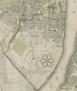
These characteristics of the area help explain the main change between Horwood’s Plan and Faden’s 1819 revision: the construction of a penitentiary. In the once-isolated area by the Tothill Fields, a penitentiary has been built. I’ll explore the human impact of the prison’s panopticon design in the next post, but here I’ll focus on the relationship between the natural environment and the location of the prison. This area is slightly more developed than in Horwood’s Plan. The Tothill Fields are gone; there are now a few streets with houses and a butter factory. Near Grey Coat School, there is now a playground for students. Moreover, Vauxhall Bridge now connects this area to the land across the Thames, and the large Vauxhall Bridge Road makes this location more accessible. Still, the area immediately surrounding the prison is largely undeveloped, and the natural environment here makes it a fitting location for a penitentiary. The nearby river allows for easy transport of prisoners, but makes escape difficult. The open space around the prison likewise inhibits escape. Moreover, the large open space allows for the sprawling panopticon design of the penitentiary. In these two views of Westminster from Horwood and Faden, we can see how its natural environment with the Thames and open land shapes the development of this area of the city.
Bridewell and Surroundings: Antiquities of London (1791-1800)
London constantly reinvents itself; John Thomas Smith’s Antiquities of London goes back in time to the first invention and builds the city back up from its relics and ruins. Within the confines of Bridewell and the surrounding area, this guidebook is able to highlight just how critical this place has consistently been for the city at large.


Smith’s engravings preserve previous versions of the city, but they also are a reminder that each reinvention of the city carries traces from past selves. At the end of the 18th century when he is making these engravings, the ruins of the London Wall—which were a part of the ancient city wall—are still there. Despite a devastating fire that burnt down nearly the whole city in 1666, Mr. Holden’s family vault in St. Bride’s Churchyard is still there.


There is a great attention to conveying the historical meaning of an engraved structure; therefore, when there is a certain engraving which misses this key trait, there are more questions raised by it than there are answered. One such engraving is the one of Mrs. Salmon’s Wax Work. The building appears to have been damaged given the fading, cracked paint on the top floor, and the fact that the building is not completely straight. Rather, it looks like certain components of the building that ought to be parallel are not because of some historical event or another. Smith’s guide, by documenting the remnants of the city’s past underlines the fragility and impermanence of the city at any one point in time as no moment in antiquity can be replicated entirely. This representation of the City of London, and Bridewell and the surrounding areas in particular shows the fleeting nature of a map of Bridewell.
