St. Giles District: Flight from Overpopulation

St. Giles District gained and lost a large percentage of its population at the beginning and end of the 19th century respectively. From 1801 to 1811, the population made a huge leap from 36,502 people to 48, 536 people, a dramatic increase of about 33%. After this initial jump, the population change of St. Giles slows down to near-zero around 1831, changing little for 4 decades. Between 1871 and 1881 this suddenly changes as the population dramatically declines to around 45,000, a 16% decrease.

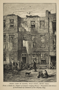
These changes can only be understood in the context of the rest of London and population density. St. Giles District remained in the highest category for population density throughout the 19th century. It’s a small district, but its central location and short distance from the city of London likely made it attractive for incomers from the countryside. Moreover, at the beginning of the 19th century, those areas closer to London tended to be more developed, allowing for a higher concentration of people to live and find work there. As the century progressed, however, more areas started to be developed. Given that the population density of St. Giles was so high, it’s likely that its denizens decided to move away from this area into the less occupied areas now more available to them.

This trend is mirrored in the different metropolitan districts of London. The categories on the map indicating population density are colored from light to dark. Lighter colors represent a smaller population density, while darker colors represent a larger population density.  Visually, the interactive map displays an inverse relationship between the darkness of the colors for central districts and time. This shows that as time progressed, many people moved from the center of London to the This creates a stronger argument that more occupations may have become available in the less populated districts as they developed. Thus, living in areas with a smaller population density may have allowed for more comfortable living and better job security due to a decrease in competition, creating an incentive for people to leave the center of London.

The argument for an increase in the development of areas further away from the center of London is further supported by observing the distribution of institutions over time. At the beginning of the century, most institutions are located in the center of London, but by 1890 the quantity of institutions grew and the institutions themselves became more evenly distributed, creating opportunities for more people to live in areas of smaller population density.

St. Giles District: Charitable Institutions on the Rise (1801 – 1890)

So much of London’s history involves a series of adaptations to shifting environments over time that poets have remarked the only constant in London is change. This is no less true for the metropolitan St. Giles District of London during the 19th century. Beginning with a workhouse and a hospital for poor married women in the period of 1801-1810, the district was already concerned with serving the poor in the area. This concern only expanded as time went by.

Three decades later more charitable institutions are added: two refuges for destitute boys and an association for improving the housing conditions of the poor. The refuges for the destitute boys gave the children basic necessities such as food and clothing.  The children were also put to work; they could learn trades like shoemaking,  tailoring clothes, and housework, or get sent to a farm,  the American colonies, or training ships to learn their trades.  Twenty years later a girl’s refuge was open as well, but closed by 1881. Here, girls were also trained for jobs, but instead as laundrywomen and house servants. It’s difficult to say why there were more refuges for boys than girls, however, one may speculate that the refuges may have derived much of their income from training children for trades, therefore, valued boys more than girls given the wider variety of trades available to males. The creation of these additional institutions showed how poverty increased in the district over time.  As children who lived in poverty couldn’t be supported by their families either due to their being deceased or an inability to find adequate work, these refuges were their only option.  The need for the association relating to housing conditions was also very telling of the poverty in this district. Housing security remained a large concern as slums were demolished and the poor evicted, hence the continued existence of this association up to 1890 and possibly beyond.

A sketch from the Victorian era of the slums near the refuges for destitute boys in St. Giles District.

Beginning in 1875, new charities began to enter the scene. Missionaries came to serve the poor in lodging house kitchens. In the next decade, when the missionaries and the girls’ refuge had left, an orphanage and almshouse were added to the district.  In this way, the number of charitable organizations increased or remained the same as the century progressed.  Moreover, the concerns of the organizations also remained the same: to house the poor and to take care of the children. The new organizations simply did this work in different ways.  While the refuges were gendered and oriented around teaching children a trade, the orphanage was open to any child who had lost a father or both parents and provided an education in addition to basic necessities.