Journeying to Red Lion Street: An Errand-Boy’s Holborn Adventure

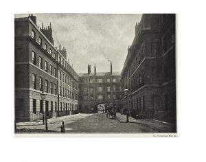
“More laudanum and some opium, quick!” were the last words you heard before you were hustled outside, handed your cap and tossed some coins. You barely register the click of the door closing behind you as you survey the bustling Gray’s Inn Road and hurry your way up the street toward Theobalds Road. Although you were initially glad to be rid of the stench and filth of the Royal Free Hospital’s dysentery quarters, your nose is soon overwhelmed by the foul smell of the horse dung and urine you slosh through on the streets. As you come across a gaggle of boys your age trying in vain to dodge the oncoming carriages and scoop up horse droppings, you feel a new wave of appreciation for your position with Dr. Marsden and pick up your pace.

A left on Theobalds Road and you suddenly have an unobstructed view of Gray’s Inn Fields, and your favorite gardens and walkways in the area. Briefly tempted to dally with the strolling masses enjoying the day, you trudge on and soon turn onto Red Lion Street. You immediately get caught up in the huddled mass of people outside your destination: L.W ROE, Chemist. Shouting, “Urgent order, Royal Free Hospital!” you shove your way through children in line for the new shipment of Ayer’s Cherry Pectoral as well as a few coughing old women, desperate for chlorodyne. Once you get to the counter, you are immediately serviced by the chemist’s apprentice, long-familiar with your face as the Hospital errand boy. He wraps your laudanum and opium (the cheap, varnish-coated kind) in brown parchment and you head back outside.

A view from the street of the chemist and the tailor (both far left) and the surrounding buildings on Red Lion Street.

Finished with your errand sooner than expected, you contemplate whether you have time to check out Furnival’s Inn on High Holborn (you heard Charles Dickens might be back in residence) but quickly think better of it. Instead, you opt to venture further down Red Lion Street. A few buildings down you marvel at the shining looking glasses in a shop window. Pressing your nose to the window and peering inside, you can see a beautiful young woman admiring a delicate handheld mirror and chatting with the shop owner while her maid waits patiently. You watch her until the shop owner spies you and lets out an angry exclamation as he storms towards the door. Time to go, you think, and walk briskly back the way you came.

A map of the route (in blue) taken by the errand boy from the Royal Free Hospital to Red Lion Street (drawings done on Edward Stanford’s map of central London). The pink “X” represents the location of the Royal Free Hospital while the orange “X” represents the block of stores (the chemist, the looking glass store and the tailor) on Red Lion Street.

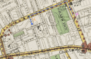
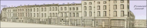
Before you turn back onto Theobalds Road, you pause at the tailor’s storefront. Looking down at your coat, torn at the cuffs and stained with the soot that permeates the air, you long for one of the stylish coats with glossy buttons featured prominently in the window. A crack of a driver’s whip brings you out of your daydream — you stood mesmerized in front of the tailor’s for far too long! Tucking your package of medicine into your chest, you race back to the Hospital, praying you return fast enough to not get your ears boxed. 

Sluggish Growth and Rapid Decline: The Population of Holborn from 1801-1890

Over the course of the 1800s, Holborn District experienced a period of steady population growth followed by a period of population decline, resulting in a net loss of a little over 5,000 people from 1801-1890. The district did not experience any real periods of rapid growth compared to other metropolitan districts. Although the population in the area grew steadily from 1801-1850, the decade of greatest growth only entailed a 9.13% increase in population from 1811-1820 (from 48,828 to 53,288 people). Other decades of growth varied between around 5% growth to as low as 1.69% growth from 1821-1830.

By 1850 the period of population growth was done and, unlike its steady growth intervals, the district began to experience a relatively steep decline in population. What started as a 4.96% decrease from 1851-1860 (59,567 to 56,612 people) became a 10.48% decrease in population from 1861-1871 and, even more dramatically, an 18.56% decrease in population from 1871-1881 (a loss of over 9,000 people). A relatively small district, Holborn started the century in the highest category for population density and, by 1890, slipped to the second-highest category for population density.

There are a couple factors to consider when looking at these fascinating population trends in Holborn. Compared to some of its neighboring districts, Holborn did not experience a period of incredibly rapid population growth. One possible reason for this might have been the Mendicity Society, an institution mentioned in my previous post and which entered the district early in the century. The Society would give out tickets to beggars, who could then travel to the Society building and use the tickets to apply for food, work or other aid. One important condition often attached to this charity was that the beggar then leave the Holborn district. While it seems unlikely that this kind of system could entirely account for why Holborn’s population growth was relatively sluggish, a steady flow of beggars out of the district due to the Mendicity Society’s efforts might have played a role in offsetting the population growth generated by migrants moving into the area.

A more important factor at play in the population change of Holborn District was the construction of Farringdon Street Station, the terminus of the world’s first underground railway (the Metropolitan Railway). This train line was crucial in facilitating the move of London’s metropolitan poor to the suburbs in search of better housing, and it appears that the residents of Holborn were among the most eager to make the suburban flight. The Railway opened in 1863, almost exactly coinciding with the beginning of Holborn’s rapid decline in population. Additionally, the creation of the Metropolitan Railway led to the destruction of thousands of homes along its route. The construction of Farringdon Street Station may have been similarly disruptive to the part of Holborn District that surrounded it as inhabitants either had to grow accustomed to a suddenly busy neighborhood with hordes of train passengers or relocate entirely.

From the Workhouse to Bed Rest: The Rise of Free, Specialized Hospitals in Holborn District

Compared to the other metropolitan work districts of London, Holborn District had scant resources to support the urban poor early in the 1800s. From 1801-1810, the only institution in the district was the Grays Inn Road Workhouse which — alongside providing shelter and work to the poor — was an institution especially ripe for exploitation of the poor, who often were forced to live (and work) in underfunded, cramped conditions with limited food. From 1811-1820, the institutional support for the Holborn poor was barely improved with the addition of the Mendicity Society, which provided the general public with tickets to give to beggars, who could then bring the tickets to the Society building and apply for relief, food or work. Like a workhouse, this institution provided imperfect aid to beggars, who would have to travel to the Society headquarters and apply only for the chance to receive aid. Sometimes the beggars would only receive aid if they agreed to leave Holborn District.

A view of Furnival’s Inn, located on the busy Holborn thoroughfare and close to Holborn’s Field Lane Refuge prior to the unisex refuge’s move to Saffron Hill in 1866.

But, although it began the century as a district that largely lacked adequate institutions to serve the poor, Holborn soon featured some new institutions with better aid mechanisms. From 1821-1830, the Royal Free Hospital became a fixture in the district and provided free medical services to anyone. Soon a women’s refuge that housed destitute girls and assisted them with finding work emerged and, by 1850, Holborn also contained the London Homeopathic Hospital, a unisex refuge, and a religious mission to aid the deaf and dumb. The shift towards charitable organizations that were more clearly built to unconditionally serve the urban poor was noticeable. 

The most interesting change in the latter half of the century for the district was the increase in specialized hospitals in the area. By 1860 the National Hospital for the Paralysed and Epileptic as well as the London Infirmary for Diseases of the Legs were present in the district and, by 1890, these medical institutions were also joined by the Alexandra Institution for the Blind, St. Paul’s Hospital (which primarily treated venereal disease), the Italian Hospital and Alexandra Hospital for Children with Hip Disease. 

The rise of these specialty hospitals raises some interesting demographic questions. For example, although the Italian Hospital served all patients, it prioritized Italian patients, leading one to wonder whether it was located near an area that Italian migrants flocked to. These hospitals also give insight into the unique medical needs of the London population. While a whole hospital wouldn’t be dedicated to children with hip disease today, hip disease was common with the tuberculosis that ravaged Victorian London. Wealthy families could afford to bring a doctor to their houses, but poorer families needed a hospital for their children’s diseases. It is striking that a district which started the 1800s with only a workhouse to serve the poor would end the century with a multitude of hospitals that catered to poor, sick Holborn residents and — rather than force them to work — actually allowed them a sponsor-funded bed and some rest.

Many a Mission: The Establishment of Institutions in Poplar As a Result of an Increase in Dockworkers

In the metropolitan work district of Poplar, at the start of the 19th century, there were no institutions. The long, narrow district on London’s east side appears to have been lightly populated between the years of 1801 and 1810, with only 8,278 persons, and thus might not have placed great demand upon the city for infrastructure and institutions. Over the course of the 19th century, however, Poplar’s population seems to have grown and evolved, and the institutions grew with it.

The West India Import Dock, from The Queen’s London: a pictorial and descriptive record

What might be most interesting about the majority of Poplar’s institutions is their focus. While the district saw an increase in workhouses and hospitals and the addition of a lunatic asylum between the years of 1801 and 1890, the most pressing issue for the area was the increase in dockworkers and sailors. The Thames marks Poplar’s southern border, and within that particular stretch of the river sits the Isle of the Dogs, now known as “the Island.” This peninsula was significant because it housed both the East India and West India docks, the sites at which imports from the West Indies and the British East Indian Company entered the city for trade.

The institutions added to the area of Poplar reflect the growth of this trade and of the population of dockworkers. Between 1851 and 1860, the Poplar Hospital For Accidents appeared on Lodore Street. The hospital was founded originally to serve only the East and West India dockworkers, suggesting that there were large numbers of dockworkers, and large enough numbers of them receiving injuries, that the city had to build a hospital to serve them exclusively. Other institutions that arose as a result of the docks were the two Missions to Seamen founded in 1881; one was in St Luke’s Church on Stratford Street, and the other was in Poplar Church on the corner of East India Dock Road and Chrisp Street.

The two workhouses added to Poplar—the first, the Bow Road Workhouse on the border of Poplar and Mile End Town Vestry, and the second, the St Leonards Street Workhouse—suggest an influx of working class and poor migrants entering the district starting in the middle of the century, likely corresponding with the rise in activity at the docks.

A Walk to Regent’s Park – Life in Marylebone

Background Investigation: Reagents Park is an important and central feature of St. Marylebone Vestry. While the park did not open to the public until the 1840’s, it was still a beautiful reprieve from the hustle and bustle of London City. In 1840, the park was opened 2 days a week to the public and hosted the London Zoo from 1847 which became a major tourist attraction in Victorian London.

The Zoo in Regent’s Park.

Your perspective: It is a beautiful summer day in 1843 and I’m planning on taking my kids to Regents Park to enjoy the summer air and see the new Elephants that Queen Victoria bought for the Zoo! I live in an apartment on Wigmore Street which is just one street over from the bustling Oxford Street, so on nice days such as today I can hear the faint commotion of street carriages and street sellers starting as early as the sunrise! Wigmore Street has all of the things I could want – there is the Knight Baker right across the street from me, a Linen and Outfitting warehouse, and G. Robinson’s Auctioneer studio for when my husband gives me a few extra shillings to spend. Another exciting location on Wigmore is The Royal Polytechnic Institute, which opened up in 1838 at the end of our street! It has brought in a lot of tourists from other boroughs to our neighborhood and has provided the public with so many innovative displays of England’s scientific discoveries. Our location is convenient for the children as well as it is just about a kilometer and a half walk to Regent’s Park.

The commotion of Oxford Street on full display.

Background investigation: Based on the Victorian London interactive map, the events hosted throughout St. Marylebone Vestry make the area appear as though it was relatively wealthy. When looking of a drawn map of the area around Wigmore Street and Baker Street, one can see numerous small block gardens, which are another indicator that those living in the area were on the wealthier side. In modern London, Marylebone is a “posh, wealthy borough that has a chic residential feel” according to London’s Financial Times.

A picture of modern day Marylebone – a “chic, residential neighborhood in London city”.

Your Perspective: As I walk the kids down Baker Street on our way to Regent’s Park, we pass the beautiful garden in Portman Square. While we appreciate our apartment on Wigmore Street, some of the houses here are much grander than our living space. We pass Portman Chapel a little farther up the street as we continue on our way. I love admiring the ladies beautiful summer frocks who pass by us on our walk I feel grateful that we live far enough from the city center to be able to walk around in fancier clothing without worrying about ruining our garments.


A Bustling Borough – Population in Marylebone

St. Marylebone Vestry had one of the highest population density boroughs between 1801 and 1810 with a population size of 63982. St. Marylebone Vestry remained one of the most inhabited boroughs in London throughout most of the 1800’s. The population saw a large increase in the years between 1810 and 1841 as it jumped to 138164, an almost 216% increase. The population increased yet again in the latter half of the 19thcentury when the population in Marylebone rose to 159254, another 115% increase from the original demographic. Interestingly, between 1871 and 1880 Marylebone’s population saw a decrease for the first time in a century transitioning from the 159254 in 1871 to 154910 in 1881.

There are two possible explanations for the decrease in population size. The first is that there was a surge in the quantity of hospitals, orphanages, and charitable organizations in the borough, which would have brought in a larger population of poorer individuals to an area that had previously had very few of these organization up until the late 1860s. The second explanation could be that Marylebone’s Vestry was on the outskirts of London and would have been an easy location for those traveling into the city to settle in to. As time progressed and more of these external boroughs became more developed, it is possible that some of the inhabitants of the area decided to move to other nearby boroughs such as St. Pancras Vestry, Paddington Vestry, and Hampstead Vestry which all saw population increases in the 1880’s.

It is interesting to note that St. Marylebone Vestry is relatively large geographically in comparison to many of the surrounding boroughs. It extends from the border of London to deep into the heart of the city. This proximity to the City of London (just a three mile walk as seen on the modern map of London) would make Marylebone an attractive location for individuals or families who would want to work but not live in the industrial section of the city. Also noteworthy is the fact that Marylebone Vestry remains heavily populated until the end of the 19tth century while almost all other districts near the heart of London become noticeably less populated every decade. I believe that Marylebone’s larger size and geographical proximity to both the countryside and City of London would lend themselves to a larger sustained population size.

Walking Distance from Marylebone to the City of London center.

A Multitude of Hospitals – Institutions in Marylebone

At the beginning of the 19thcentury, there were very few institutions in St. Marylebone Vestry; the primary institutes in the borough were hospitals and orphanages. There was very little change in the quantity and diversity of establishments in Marylebone up until the 1830’s when the Marylebone Workhouse and London Society for Teaching the Blind were created. Yet, the the overwhelming majority of establishments in the borough continued to be hospitals and other charitable institutions. It was only in the 1860s and 70s that the number of businesses and organizations grew in numbers, which is consistent with most of the other boroughs outside the center city of London.

A business that was particularly interesting to me was Middlesex Hospital, which was one of the largest buildings on Mortimer Street where it was located. When looking at this image and other ones I found on the internet, I was surprised with how sophisticated the hospital appeared from the outside. The structure of the hospital was impressive, and it looked as though it almost took up an entire block. I was hoping to compare the Middlesex Hospital with some of the other hospitals located in Marylebone, but there were no other street views of them.

The impressive Middlesex Hospital on Charles Street.

In the late 19thcentury, the kinds of institutions found throughout Marylebone remained predominately the same but increased in numbers. For example, a multitude of other hospitals were established in close proximity to one another just north of Middlesex Hospital. These hospitals catered to different issues such as the Wester Skin Hospital, The London Throat Hospital, and the Hospital for Epilepsy and Paralysis. Marylebone definitely housed more hospitals in a smaller square mileage than any of the other boroughs and I think this illustrates that it was prudent for people of similar professions to be located in the vicinity of one another so that they could be easily located by individuals seeking medical attention. I found it interesting that most of the hospitals at the time were specialized in a specific disease or body part as opposed to being combined under one umbrella hospital. The hospital I found most interesting was the Hospital for Gentlewomen During Temporary Illness. In order to go to this establishment, a woman would have to be of a certain class or the wife of a clergyman, professional, etc. I think that the presence of a hospital for higher class individuals possibly indicates that Marylebone was a relatively affluent location within the City of London.

Mapping Modern London: The Social Aesthetics of Westminster

The Modern London (1804) Guidebook to Landmarks embodies the civic duties and social atmosphere popular in the City of Westminster wherein the social motivations and priorities surround the promotion of London’s burgeoning culture and the traditions of the professional and those adjacent to the Crown. 

The Society of Arts encapsulates the public spirit of the age through its encouragement of the rapid progress and the prospering condition that contribute to London as a burgeoning Metropolis. Founded by William Shipley and other private gentlemen in 1754, this institution commends and awards Premiums and prizes to individuals who have achieved success in areas encouraging the arts, manufactures, and commerce. Oblong and elegantly proportioned, the meeting room is arranged in an oval form, where portraits of noble lords and The President, his Grace the Duke of Norfolk, are hung with esteem. The Society’s prominence is acknowledged in the seating of the committee, wherein the distinguished attendees include the Secretary, the Assistant Secretary, the Vice-Presidents and Chairmen of Committees, ladies of rank, and duchesses, foreign ministers, and other dignitaries of distinction. 

A sketch of the Society of Arts, located in the Modern London (1904) Guidebook to Landmarks, situated between Covent Garden and Westminster, in a moment of awarding its annual prizes for the encouragement of arts, manufactures, and commerce.

In continuing with the Society’s reputation for the encouragement of excellence in the arts and commerce, the walls are decorated with a series of paintings, among the finest productions of the age, to represent man’s progress in civilization. Remarked by the refinement of its taste, these paintings include the Society’s President as part of the Olympic Games, a picture of prominent men in robes distributing the rewards of the Society, and the Triumph of Navigation, where Father Thames, designed with charming extravagance, sits in a car being drawn by river nymphs. The exquisite atmosphere projected by the Society of the Arts infers that the priorities of this guidebook correlate with the notion of leisure, in that, this landmark, considered one of the finest spectacles in Europe, is tailored to describe those who have the luxury and time to promote artistic expression and culture.

A sketch of the three principal offices connected with the government of the country: The Treasury (right), The War-office (center), and The Admiralty (left) from the Modern London (1904) Guidebook to Landmarks. The Parade of the Foot Guards present themselves in the foreground.

The guidebook details the Horse Guards or War-Office, wherein the landmark indicative of these public buildings is one of the finest about the Metropolis. In one view, this landmark beholds three principal offices connected with the government: The Treasury, The War-office, and The Admiralty. The War-Office, located in the center of the three, comprises the station where part of his Majesty’s troops usually perform duty. The Treasury, located to the right of the War-Office and enclosed with a wall, contains the gardens of the house, while the building to its left is The Admiralty, home to the apartments and offices of lords. The significance of government buildings prioritizes a professional, educated attitude surrounding the inhabitants of Westminster.

The Parade of the Foot Guards, another landmark, celebrates tradition and honors achievements, as inferred from the decor of the Turkish piece of ordinance. Brought by British troops from Alexandria, the ordinance is mounted on a carriage of English workmanship and ornamented with very elaborate devices to display London’s successes and global reach.


Populating the Social Elite: The Proliferation of Gardens and Entertainment in the Liberty of Westminster

Neighboring the Queen’s Palace, the demographic of Westminster’s population comes across as less dense than the surrounding area of London as delineated by the red line on Horwood’s Plan (1792-1799). Comparable to the city and its additional boroughs, Westminster gives the impression it is heavily populated. However, the city’s residence next to Saint James’s Park, Green Park, and the Queen’s Gardens, as well as the city’s location, a mere one street from the River Thames, give the illusion of more open space. While London, as a whole, persists upon its placement about the Thames, the institutions of which make up the City of Westminster strongly point to its higher-class residency, who, of which, make up the court, the nobility, and other people of distinction, with a certain composition of tradesmen and artists. Dividing the City of Westminster into subcategories based on points of interest: establishments of leisure and entertainment, institutions of reverence, and buildings that pertain to the adjacent parts of the royal services, we can begin to comprehend the livelihood and professional nature of this upper-crust population. 

A screenshot of Fores’s Guide (C. 1789) indicating the close proximity of The Little Theatre (above) and the Italian Opera (below) on Haymarket Street.

The presence of two theatres on Haymarket Street indicates that those who live in this area can afford leisure activities or comprise the actors that perform at these companies. The seasonal nature of this amusing pastime, The Little Theatre’s summertime availability, and the Italian Opera’s wintertime entertainment emphasizes that this leisure activity is offered only to those who can afford to enjoy the social and cultural amenities of year-round entertainment.

In addition to Saint Martin’s Church, a notable institution of reverence and considered one of the finest churches in London, The Banqueting House of Whitehall demands the same category of distinction. Host to daily divine service, The Banqueting House of Whitehall beholds a statue of James II upon a pedestal, esteemed to be one of the finest of its kind in England, and serves as an area of notoriety, praise, and respect.

The Admiralty is a large office and apartment building occupied by the lords that possess a large hall and seven spacious houses appointed only to the lords and commissioners of The Admiralty. The elegant wall designated in front of the court gives The Admiralty its air of exclusivity and prominence.

With Westminster’s proximity to the Queen’s Palace, The Horse Guards and The Kings Mews are buildings that concern adjoining parts to royal services. The King Mews, or the falconry of the King, was converted into a stable for horses and coach of state by Henry VIII. Constantly on duty as sentinels, the armed troops that constitute The Horse Guards stand watch on horseback. However, this building serves a dual purpose, functioning as a control point to a vaulted passage that leads into Saint James’s Park.

The prominence that these points of interest indicate that the inhabitants of Westminster are educated and affluent, and those employed by these institutions are likely in the service of the Queen.


Leisure and the Social Elite: Color and the Environment in the City of Westminster

The environment surrounding the City of Westminster and its adjacent parts favors the occupation of the social elite as well as the polite and commercial artists. Where the main feature of the natural environment in the City of London gravitates around the River Thames, running centrally through the city, the built environment surrounding the Liberty of Westminster differs from the domains encircling the Tower of London and the Docklands that run along the water. As topographically delineated by the red line separating London proper from the surrounding areas in Horwood’s Plan (1792-1799), the City of London is predominantly impacted by buildings and industry, with a notable lack of surrounding natural environment that exists apart from the River Thames. This contrast is especially distinct when juxtaposed with the surrounding environment outside of this topographical border; wherein the geographics of Westminster possess more freedom for leisure with its numerous fields and gardens than the rest of London’s inherently compact, urban cityscape. Rather than the occupation of industrial warehouses and wharves, as is the case closer to the city surrounding the Tower, the buildings located alongside the River Thames in Westminster cater towards a more dignified and upper crust crowd that persists in this location so close to the Queen’s Palace and Parliament Street. This stretch along the River Thames consists of the Privy Gardens, Westminster Hall, and Northumberland Gardens, with a few wharves recognized by the names Scotland Yard and White Hall Timber Yard.

The area surrounding the intersection of Charing Cross and Cockspur Street is relatively similar in both Horwood’s Plan (1792-1799) and Faden’s 1819 revised mapping of London. The built environment remains the same, favoring the habits of the upper class and persons of notable distinction, such as the royal family and members of Parliament, wherein occupancies of leisure, such as opera houses, gardens, and squares, persist more frequently compared to the more industrialized and mercantile subsection of London that makes up the habitations of tradesmen and the merchant class. While Haymarket Street and its opera houses prevail into Faden’s 1819 revision, Regent Street, running perpendicular to Charles Street outside of Saint James’s Square, is a new addition that had required the tearing down of residences that line Haymarket Street in Horwood’s Plan. The incorporation of color, however, in Faden’s 1819 revision, gives light to the overwhelming presence of gardens. While the existence of gardens persists more frequently in the Liberty of Westminster, as indicated by Horwood’s Plan of London (1792-1799), the color reveals how expansive and frequent these gardens appear to exist. The existence of such gardens alongside the River Thames, in particular, delineated in this stretch that borders Westminster and Covent Garden noted in the 1819 revision, is much more frequent than the showing of gardens located near the Thames in the Docklands. Faden’s attention to color characterizes the Liberty of Westminster by its inhabitants’ accessibility to leisure activities, systematizing London’s burgeoning Metropolis through this geographical assumption by class to suggest that the occupants in this subsection of London concern the social elite.