
Caption
Economic Engine – Western Pacific Rim, 1989
Summary
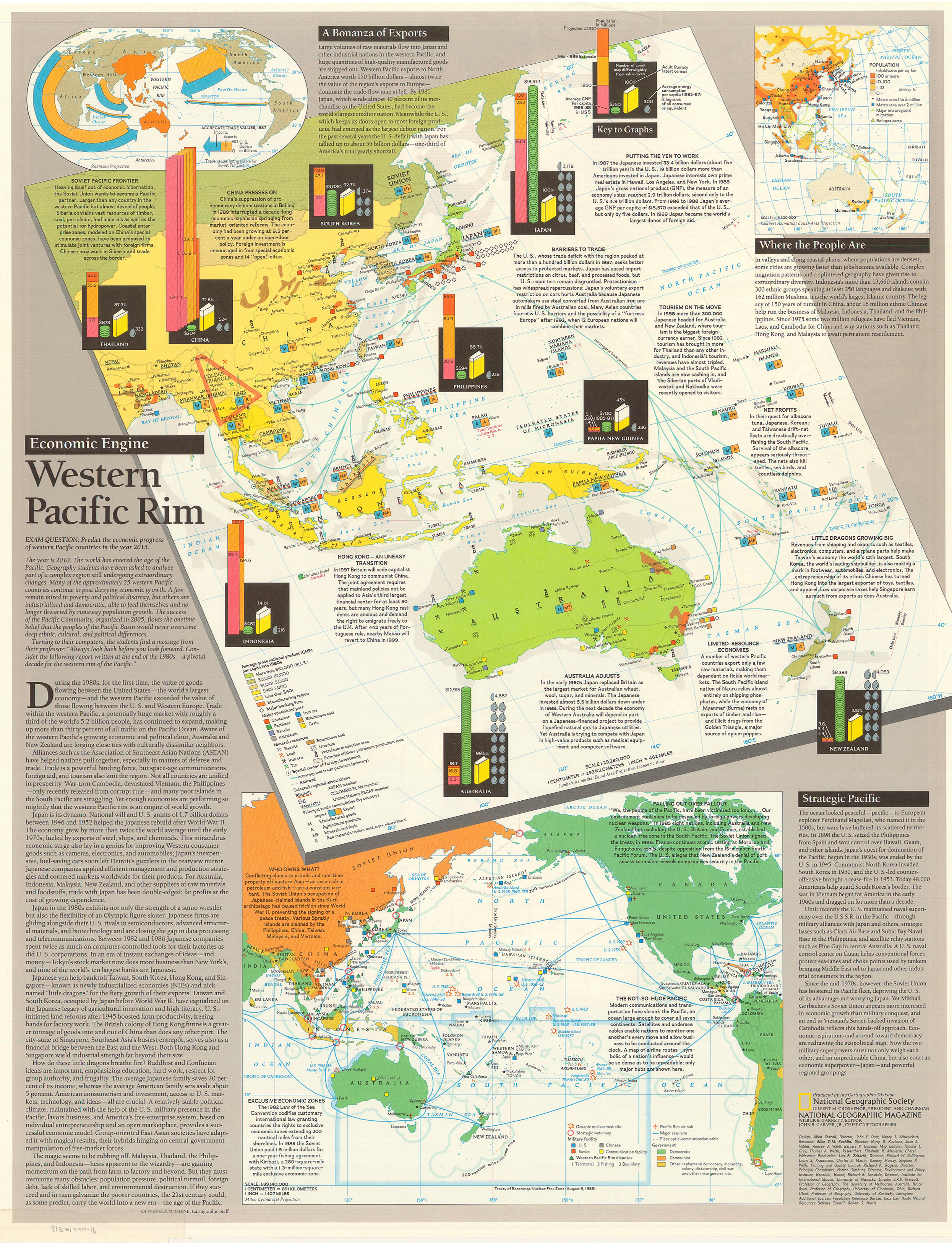
This poster about the development and economic growth of the Western Pacific Rim
includes four maps, as well as graphs and extended narratives.
The main map shows:
- average gross national product (GNP) per capita (late 1980s)
- population (1950, mid-1989 estimate, projected for 2000)
- adult literacy
- average energy consumption per capita (1985-87)
- manufacturing regions
- the location of major banking firms
- specialized ports (Container, Fertilizer, Bauxite, Petroleum, Iron ore, Bituminous coal, Grain)
- Mineral Resources (Bauxite, Lead, Iron Ore, Tin, Bituminous coal, Uranium)
- Petroleum production area
- Potential offshore production area
- Special Center of Foreign Investment
- Intraregional trade partners (primary)
- Railroad
- Selected regional associations
- ASEAN member
- COLOMBO PLAN member
- United Nations ESCAP member
- Principal trade commodities (by country) (Import/Export)
- Manufactured Goods
- Agricultural Products
- Minerals and fuels
- Raw materials (rubber, wood, copra, natural fibers)
One inset map labeled “Where the People Are” shows population density, metropolitan areas, major intraregional migration, and refugee camps. Another shows trade relations between the western Pacific region as a whole and other regions of the world.
A fourth map is color-coded according to the type of government
(Democratic, Communist, Other), and shows exclusive economic zones,
the Treaty of Rarotonga Nuclear Free Zone (1985),
military facilities, communication routes, and territorial disputes. This map’s legend is as follows:
- Star: Oceanic nuclear test site
- Red Circle: Strategic waterway
- Military facility:
- Blue: U.S.
- Red: Soviet
- Gray: Chinese
- Yellow: Communication facility
- Western Pacific Rim Disputes (Territorial, Fishing, Boundary)
- Red airplane: Pacific Rim air hub
- Blue line: Major sea-lane
- Intermittent black line: Fiber optic communication cable
- Government:
The poster was published as a supplement to four articles including
“Hanoi: The Capital Today” and the Asia-Pacific map in the November
1989 issue of National Geographic.
See [1].
Source
Produced by the Cartographic Division of the National Geographic Society, National Geographic Magazine, 1989.
This map is in the collection of copyrighted maps of the Geosciences and Map Library, Fine Hall (B level), Princeton University.
Call number: G3201.Q42.1989.N3
Copyright
© National Geographic Society, 1989