
Caption
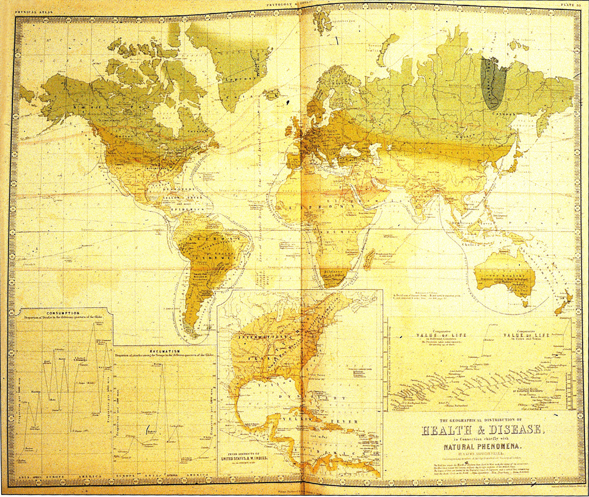
The Geographical Distribution of Health and Disease, in connection chiefly
with Natural Phenomena
Summary
“Lines chart the progress of disease (by time and type) between countries …
The names of each disease are noted in areas of endemic occurrence. The result defines a landscape of disease districts … across each country.” (Koch, p.68)
The red lines show the progress of cholera.
Other diseases mentioned include:
- Ague
- Catarrh
- Consumption
- Cretinism
- Diarrhea and Dysentry
- Dysentry
- Elephantiasis
- Goitre
- Guinea Worm
- Influenza
- Intermittent Fever
- Intestinal Worms
- Leprosy
- Liver Disease
- Measles
- Opthalmia
- Remittent Fever
- Rheumatism
- Scarlatina [Scarlet Fever]
- Smallpox
- Yellow Fever
The image currently available on QED is of low quality but is included because of the map’s historical significance.
Source
The image was scanned from Fig 3.11a in Tom Koch (2005). Cartographies of Disease. ESRI Press, Redlands, California.
The original source is Johnston, A.K. (1856). The Physical atlas of natural phenomena. Edinburgh: W. Blackwood.
Copyright
The two-dimensional work of art depicted in this image is in the public domain in the United States and in those countries with a copyright term of life of the author plus 100 years. This photograph of the work is also in the public domain in the United States (see Bridgeman Art Library v. Corel Corp.).
Collection
|
Transmission Routes of Cholera (1817-1831) |
 The Progress of the Spasmodic Cholera, 1832 |
 United States Cholera Route – Epidemic of 1832 |
 Broad Street Outbreak of Cholera, London, 1854 |
 The Geographical Distribution of Health and Disease, 1856 |
 The March of Cholera in 1865 |
 The Diffusion of Cholera in the United States in 1866 |
 Diffusion of Cholera in Eastern Africa, 1864-1871 |
 Cholera Diffusion in Zanzibar c. 1869 |
 Historical cholera pathways in 1817-1823 and 1863-1869 |
 Routes of Asiatic Cholera (1885) |
 Network of cholera diffusion in India, c1931-1953 |
 Cholera, 2000-2001 |
 Cholera, 2003 |