Caption
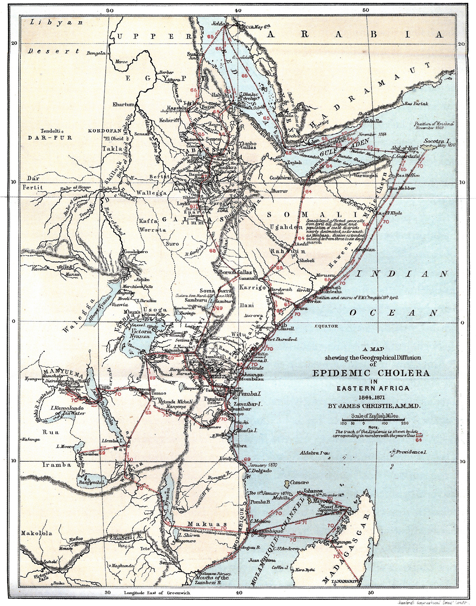
A Map shewing the Geographical Diffusion of Epidemic Cholera in Eastern Africa 1864-1871
In Koch (2005), the caption is
“Christie’s map of cholera diffusion in East Africa. Sequential numbers are used in the text to describe the diffusion of the disease by caravan, religious pilgrimage, and sea routes.”
Summary
At the time this map was produced, expert opinion still attributed the spread of cholera to “bad air” and an “aerial highway”.
For example, based on geographical analysis, Dr Bryden of India’s Sanitary Commission claimed in his “Report on the General Aspects of Epidemic Cholera in 1869” that he had deduced the existence of an “aerial highway” carrying the disease across Africa (Koch, p 184).
In this map, which was published in 1876, the physician James Christie provides the contrary evidence in great detail. Christie also pointed out that earlier East African outbreaks (1836-1837, 1858-1959) had occurred in Arabian and Red Sea ports to and from which pilgrims to Mecca traveled.
Legend
“The track of the Epidemic is shewn by dots corresponding in numbers with the years thus …”.
That is, “65” indicates the year 1865.
Source
The image was scanned from Fig 7.9 in Tom Koch (2005). Cartographies of Disease. ESRI Press, Redlands, California.
The original map was published in Christie, J. (1876). “Cholera Epidemics in East Africa: An Account of the Several Diffusions of the Disease in that Country from 1821 till 1872, with an Outline of the Geography, Ethnography, and Trade Connections of the Region through which the Epidemics Passed”. London: MacMillan.
Collection
 The Diffusion of Cholera in the United States in 1866 |
|||
 Historical cholera pathways in 1817-1823 and 1863-1869 |
 Network of cholera diffusion in India, c1931-1953 |
||
|
Cholera, 2000-2001 |
Copyright status
The two-dimensional work of art depicted in this image is in the public domain in the United States and in those countries with a copyright term of life of the author plus 100 years. This photograph of the work is also in the public domain in the United States (see Bridgeman Art Library v. Corel Corp.).


