
Caption
Millennium in Maps – Diversity of Life, 1999
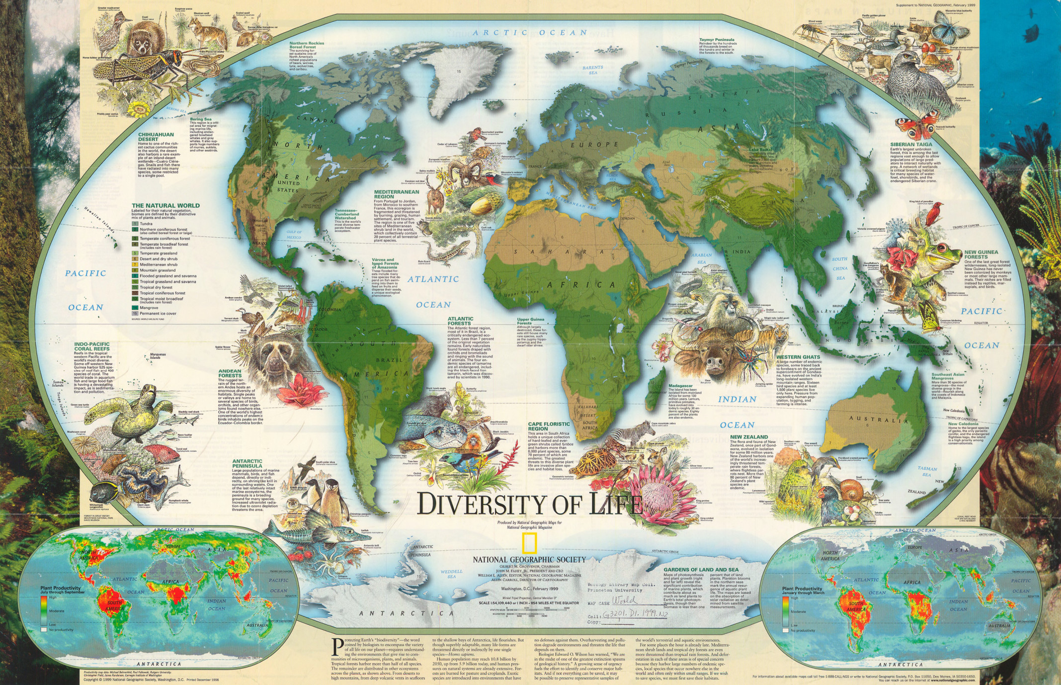
Summary
This poster includes three world maps, an extended essay and supplementary descriptions.
The main map is color-keyed according to natural biomes, defined by their distinctive mix of vegetation and animals.
The two smaller maps show “Plant Productivity” for July through September and for January through March.
The legend for the main map is labeled “The Natural World” and indicates:
- Tundra
- Northern coniferous forest (also called boreal forest or taiga)
- Temperate coniferous forest
- Temperate broadleaf forest (includes rain forest)
- Temperate grassland
- Desert and dry shrub
- Mediterranean shrub
- Mountain grassland
- Flooded grassland and savanna
- Tropical grassland and savanna
- Tropical dry forest
- Tropical coniferous forest
- Tropical moist broadleaf (includes rain forest)
- Mangrove
- Permanent ice cover
Descriptions of the following ecosystems are provided:
- Indo-Pacific Coral Reefs
- Andean Forests
- Antarctic Peninsula
- Chihuahuan Desert
- Mediterranean Region
- Siberian Taiga
- New Guinea Forests
- Western Ghats
- New Zealand
- Cape Floristic Region
- Atlantic Forests
Additional information is provided for the following regions:
- Bering Sea
- Northern Rockies Boreal Forest
- Tennessee-Cumberland Watershed
- Varzea and Igapo Forests of Amazonia
- Upper Guinea Forests
- Taymir Peninsula
- Southeast Asian Mangroves
- New Caledonia
- Madagascar
Source
Produced by National Geographic Maps for National Geographic Magazine, February 1999.
Data source: World Wildlife Fund.
This map is in the collection of copyrighted maps of the Geosciences and Map Library, Fine Hall (B level), Princeton University.
Call number: G3201.D1.1999.N2
Copyright
© 1999 National Geographic Society, Washington D.C. All rights reserved.
Series
This map is one in a series:
- Image:MG©Millennium in Maps – Biodiversity, 1999.djvu
- Image:MG©Millennium in Maps – Cultures, 1999.djvu
- Image:MG©Millennium in Maps – Diversity of Life, 1999.djvu
- Image:MG©Millennium in Maps – Population, 1999.djvu
- Image:MG©Cultures – Consumption and Circulation, 1999.jpg