
A .pdf version of this map is available here.
Summary
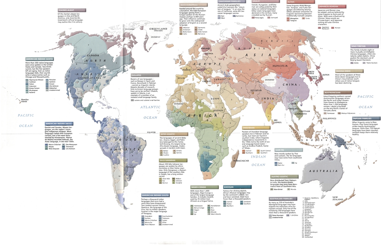
The map identifies the areas associated with specific languages
grouped by language family as follows:
- Eskimo-Aleut
- “Of this family’s dozen languages… only Greenlandic … may outlive the 21st century.”
- American Indian (North)
- Algonquian-Ritwan; Caddoan; Hokan; Iroquoian; Kiowa-Tanoan; Penutian; Salishan; Siouan; Uto-Aztecan; Wakashan
- American Indian (Meso-)
- Macro-Chibchan; Mayan; Mixe-Zoquean; Oto-Manguean; Totonacan
- American Indian (South)
- Arawakan; Kariban; Macro-Chibchan; Macro-Ge; Pano-Takanan; Quechumaran; Tukanoan; Tupian
- Afro-Asiatic
- Berber; Chadic; Cushitic; Omotic; Semitic
- Nilo-Saharan
- Chari-Nile; Fur; Komuz; Maban; Saharan; Songhai
- Niger-Congo
- Adamawan; Benue-Congo; Dogon; Gur; Ijo; Kordofanian; Kru; Kwa; Mande; West Atlantic
- Khoisan
- Central; Hadza; Northern; Sandawe; Southern
- Dravidian
- Central; Northern; South Central; Southern
- Kam-Tai
- Kadai; Kam-Sui; Tai
- Austro-Asiatic — 2 specific languages
- Mon-Khmer; Munda
- Australian Families — “only five of the remaining 250 languages have more than a thousand speakers
- Pama-Nyungan; 23 other named languages are grouped together
- Papuan Families — “more than 750 Papuan languages have been counted”
- Austronesian — “more than 1,200 languages remain”
- Hmong-Mien — “three dozen languages” are extant
- Sino-Tibetan — “this family includes eight or more mutually unintelligible Chinese languages, often mistakenly called dialects”
- Sinitic; Tibeto-Burman
- Indo-European
- Albanian; Armenian; Balto-Slavic; Celtic; Germanic; Greek; Info-Iranian; Romance
- Caucasian — “some 40 Caucasian languages survive”
- East; West; Kartvelian
- Uralic
- Finno-Ugric; Samoyed
- Altaic
- Mongolian; Tungusic; Turkic
- Japanese/Korean
- Japanese-Ryukyuan; Korean
In addition, regions where isolates and isolated small families “persist as linguistic islands”
are indicated.
Source
National Geographic Atlas of the World, 8th Edition, 2004.
Published by the National Geographic Society.
Copyright
© 2005 National Geographic Society
Map used on the QED website with permission of the National Geographic Society.
Series
This map is one in a series:
- Image:Language Tapestry c. 2004.jpg
- Image:MG©Energy and Minerals, 2005.jpg
- Image:MG©Regional Trade Agreements, 2005.jpg
- Image:MG©Flow of Oil in the World, 2005.jpg
- Image:MG©World Grains, 2005.jpg
- Image:MG©World Debt, 2005.jpg
- Image:MG©World Forests, 2005.jpg
- Image:MG©Inter-Region Agricultural Trade, 2005.jpg
- Image:MG©Tourist Arrivals Worldwide, 2005.jpg
- Image:MG©The Internet Explosion, 2003.jpg
- Image:MG©Average daily per capita calorie consumption, 2005.jpg
- Image:MG©Connecting the Planet – Cables and Satellites, 2004.jpg
- Image:MG©Gross Domestic Product, 2005.jpg
- Image:MG©Labor Migration, 2005.jpg
- Image:MG©Chemical, Biological and Nuclear Weapons, 2005.jpg
- Image:MG©Political regimes, 2005.jpg
- Image:MG©Human Trafficking, 2005.jpg
- Image:MG©Peacebuilding, 2005.jpg
- Image:MG©International Migration, 2004.jpg
- Image:MG©Terrorism, 1995-2003.jpg